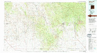
1990s Maps of Luna County, New Mexico
Explore 18 historic maps of Luna County from the 1990s. These maps offer a rare glimpse into what life looked like during the 1990s — showing old roads, neighborhoods, homes, and landmarks that have changed or disappeared over time.
Whether you're researching your family's past, planning a metal detecting trip, or studying how Luna County's landscape evolved across the 1990s, these high-resolution maps are a powerful tool for exploring the history of this region.
- Focus on a specific era: All maps on this page are from the 1990s, giving you a focused view of this time period.
- See what’s changed: Compare century-old streets, trails, and buildings to today's modern landscape using overlays and satellite layers.
- Research with precision: Use these maps for genealogy, historical research, land use analysis, or educational projects.
- View, download, or print: Maps are fully viewable online in high resolution, and can be downloaded or printed for your own records.
Start exploring Luna County's history through authentic maps from the 1990s. This is your window into the past.
Luna County, NM maps
(18)- 1992 Map of Whitewater
 1992 Whitewater1992 Print · USGSThe high desert of Grant and Luna counties comes into focus during the early nineties, revealing a landscape of shifting arroyos and old transit lines. Genealogists and historians can trace the Old Railroad Grade near Whitewater or locate landmarks like Hogback Mountain.
 - 1992 Map of Faywood Station
 1992 Faywood Station1992 Print · USGSHigh desert industry and drainage patterns define this Grant County landscape in the early nineties. Researchers can trace the layout of Faywood Station or examine the industrial footprint of the Tailings Pond and Aqueduct.
 - 1994 Map of Silver City
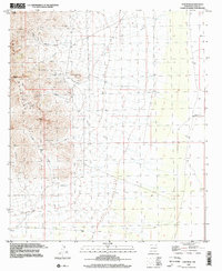
 1994 Silver City1994 Print · USGSThe mining heart of Grant County is revealed in the mid-1990s as the massive industrial footprints of the copper industry shaped the landscape. Genealogists and historians can trace the rail lines of the Atchison Topeka and Santa Fe RR or locate landmarks like Fort Bayard State Medical Center and White Signal.
 - 1996 Map of Hockett, 2002 Print
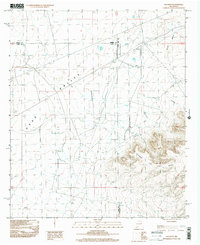 1996 Hockett2002 Print · USGSArid grazing lands and high-desert ranges define this mid-1990s region at the intersection of three counties. Genealogists and historians can trace the remote settlement of Hockett or locate infrastructure like the Sub Sta and the Gravel Pit near Horse Canyon.
 - 1996 Map of Gym Peak, 2002 Print
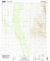
 1996 Gym Peak2002 Print · USGSThe Florida Mountains in the late twentieth century reveal a landscape shaped by high-desert mining and survival. Geologists and local historians can trace the locations of the Silver Cave Mine, Pacheco Mine, and numerous Prospect sites throughout Victorio Canyon.
 - 1996 Map of West Lime Hills, 2002 Print
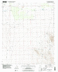 1996 West Lime Hills2002 Print · USGSThe high-desert borderlands of Luna County appear in the mid-nineties as a landscape of remote ranching and mineral prospecting. Researchers can trace the layout of the White House Ranch and locate historical workings at the Mahoney Mines or Suckerville.
 - 1996 Map of Malpais Hill, 2002 Print
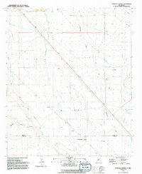
 1996 Malpais Hill2002 Print · USGSThe high desert of the New Mexico-Chihuahua borderlands is captured here in the late twentieth century, showing a landscape shaped by ranching and rail history. Trace the path of the Old Railroad Grade and locate family outposts like Dogtown Ranch and Edwards Ranch.
 - 1996 Map of South Peak, 2002 Print
 1996 South Peak2002 Print · USGSThe Florida Mountains and arid basins of Luna County are captured in this mid-nineties survey, showing the landscape before the turn of the millennium. Researchers can trace land use through local landmarks like Crawford Ranch, Mc Bee Windmill, and the mining Prospects in the high canyons.
 - 1996 Map of Florida Gap, 2003 Print
 1996 Florida Gap2003 Print · USGSThe Florida Mountains meet the high desert plains in the 1990s, revealing a landscape of remote ranching and mineral prospecting. Researchers can locate family-named sites like Kil Ranch and the Lewis Cem, or trace early mining at the Bradley Mines.
 - 1996 Map of Columbus SE, 2003 Print
 1996 Columbus SE2003 Print · USGSThe international boundary between New Mexico and Chihuahua defines this landscape as it appeared in the mid-nineties. Researchers can trace borderland settlements like Puerto Palomas and Nuevo Horizonte alongside landmarks like Black Hill and Stiles Reservoir.
 - 1996 Map of Carne, 2003 Print
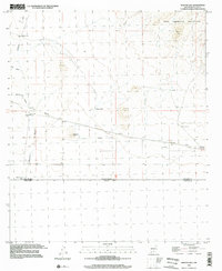
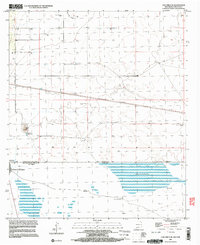
 1996 Carne2003 Print · USGSThe high desert plains of Luna County are captured here in the mid-nineties, showing a landscape shaped by rural ranching and infrastructure. Researchers can trace water sources across the Lewis Flats and locate landmarks like the Carne settlement and Wolf Windmill.
 - 1996 Map of Columbus, 2003 Print
 1996 Columbus2003 Print · USGSThe borderlands of New Mexico and Chihuahua are documented here in the mid-nineties, centered on the historic town of Columbus. Researchers can trace the Old Railroad Grade, locate the Port of Entry U.S. Customs, and explore the rugged Tres Hermanas Mountains.
 - 1996 Map of North Peak, 2003 Print
 1996 North Peak2003 Print · USGSSouthern New Mexico ranching and mining come into focus during the mid-1990s as the high peaks of the Florida Mountains region are surveyed. Researchers can trace land use through remote outposts like Inmon Ranch, the Lindy Ann Mine, and the arid paths of Seventysix Draw.
 - 1996 Map of Bowlin Ranch, 2003 Print
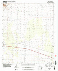
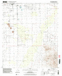
 1996 Bowlin Ranch2003 Print · USGSThe southern outskirts of Deming and the surrounding high desert are captured here in the mid-1990s. Researchers can trace rural infrastructure including the Sunshine Sch, the namesake Bowlin Ranch, and the Hermanas Grade.
 - 1996 Map of Deming West, 2003 Print
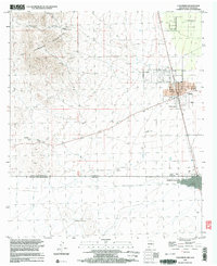
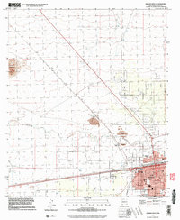 1996 Deming West2003 Print · USGSDeming stood as a bustling rail and industrial crossroads in the late nineties, where the high desert meets a growing urban grid. Genealogists and historians can trace local landmarks like Holy Cross Cem, the Asarco Mill, and the settlement at Peruhill.
 - 1996 Map of Capitol Dome, 2003 Print
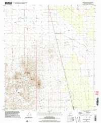
 1996 Capitol Dome2003 Print · USGSIn the mid-1990s, the desert basin of Luna County met the high peaks of the Florida Mountains in a landscape of ranching and mining. Trace family land at Spanish Stirrup Ranch or explore the mountain terrain of Rock Hound State Park and the Copper Queen Mine.
 - 1996 Map of Deming East, 2003 Print
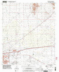 1996 Deming East2003 Print · USGSDeming and the surrounding high desert are captured in the late twentieth century as the city expanded along the river and rail lines. Genealogists and historians can trace local landmarks like Mountain View Cemetery, the Bell School, and the path of the Southern Pacific railroad.
 - 1996 Map of Columbus NE, 2003 Print
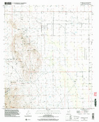
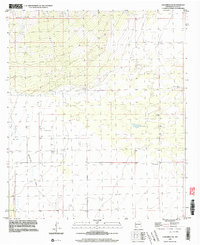 1996 Columbus NE2003 Print · USGSThe high desert of Luna County comes into focus in the mid-1990s, revealing a landscape shaped by ranching and water management. Researchers can trace the cattle-country infrastructure through features like Seventysix Draw, Coyote Windmill, and Oney Tank.
End of results
Showing maps 1-18 of 18
Top cities of Luna County
Frequently asked questions
- What are the different types of historical maps available for Luna County?
- What is the oldest map of Luna County?
- Where can I purchase historical maps of Luna County for my home or office?
- Where can I download high-res historical maps of Luna County?
- Are there historical topographic maps available for Luna County?
- Is there historical aerial imagery available for Luna County?
- Where are historical maps of Luna County sourced from?