1990s Maps of McKinley County, New Mexico
Explore 23 historic maps of McKinley County from the 1990s. These maps offer a rare glimpse into what life looked like during the 1990s — showing old roads, neighborhoods, homes, and landmarks that have changed or disappeared over time.
Whether you're researching your family's past, planning a metal detecting trip, or studying how McKinley County's landscape evolved across the 1990s, these high-resolution maps are a powerful tool for exploring the history of this region.
- Focus on a specific era: All maps on this page are from the 1990s, giving you a focused view of this time period.
- See what’s changed: Compare century-old streets, trails, and buildings to today's modern landscape using overlays and satellite layers.
- Research with precision: Use these maps for genealogy, historical research, land use analysis, or educational projects.
- View, download, or print: Maps are fully viewable online in high resolution, and can be downloaded or printed for your own records.
Start exploring McKinley County's history through authentic maps from the 1990s. This is your window into the past.
McKinley County, NM maps
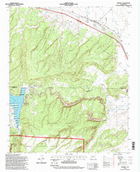
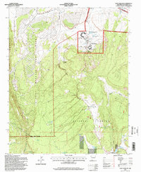
(23)- 1995 Map of San Mateo, 1997 Print
 1995 San Mateo1997 Print · USGSThe high plateau of New Mexico's western ranchlands comes into focus in the mid-1990s as it transitions toward the forest boundary. Researchers can trace land grants and water sources from San Mateo to the San Mateo Mine and Marcus Ranch.
 - 1995 Map of Pinehaven, 1997 Print
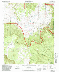
 1995 Pinehaven1997 Print · USGSThe McKinley County highlands are captured here in the mid-1990s as the national forest meets tribal reservation lands. Genealogists and local historians can locate the Pinehaven Cemetery, the Navajo Church, and the settlement of Nelson.
 - 1995 Map of Cerro Pelon, 1997 Print
 1995 Cerro Pelon1997 Print · USGSThe high mesa country of Cibola County is captured here in the mid-nineties, showing the intersection of Spanish land grants and national forest lands. Researchers can locate historic water sources and camps like Fernandez Camp Spring, La Mosca Lookout, and San Lucas Spring.
 - 1995 Map of Ramah, 1997 Print
 1995 Ramah1997 Print · USGSIn the mid-nineties, this part of the Continental Divide shows the intersection of high-desert ranching and the forested slopes of the Zuni Mountains. Researchers can locate legacy family sites like Old Bond Ranch and Clawson Homestead or trace the Mormon Colony Cemetery near the Ramah Reservoir.
 - 1995 Map of Bread Springs, 1997 Print
 1995 Bread Springs1997 Print · USGSThe high desert south of Gallup comes into focus in the mid-1990s, where traditional ranching and mining meet federal land management. Researchers can trace historic routes like Old Zuni Road or locate local landmarks including the Navajo Mission, Cresto Ranch, and Umbrella Rock.
 - 1995 Map of Continental Divide, 1997 Print
 1995 Continental Divide1997 Print · USGSThe McKinley County highlands come into focus during the mid-nineties, showing the critical junction of the Continental Divide and major rail lines. Researchers can trace the layout of Coolidge, locate the Coolidge Navajo Church, and find industrial sites like the Gonzales Siding.
 - 1995 Map of Page, 1997 Print
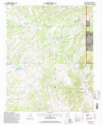
 1995 Page1997 Print · USGSThe high country of McKinley County in the mid-1990s reveals a landscape of isolated ranching outposts and rugged mountain ridges. Genealogists and researchers can trace family-named sites like Radosevich Ranch, Polich Place, and the small settlement at Page.
 - 1995 Map of Dos Lomas, 1997 Print
 1995 Dos Lomas1997 Print · USGSNorthwestern New Mexico’s high desert plateau was a hub of intense mineral extraction in the 1990s. Genealogists and industrial historians can trace early ranching at Rancho del Puerto alongside massive operations like the Anaconda Section Nine Strip Mine and Zia Mines.
 - 1995 Map of Prewitt, 1998 Print
 1995 Prewitt1998 Print · USGSThe high mesa country of McKinley County in the mid-1990s reveals a land shaped by the Atchison Topeka and Santa Fe railroad and desert ranching. Genealogists and local historians can trace the foundations of Prewitt, find the Prewitt PO, and explore the shoreline of Bluewater Lake at the foot of Salitre Mesa.
 - 1995 Map of Fort Wingate, 1998 Print
 1995 Fort Wingate1998 Print · USGSFort Wingate and the surrounding Zuni Mountains are captured here in the mid-1990s at a time of transition for the historic military depot. Researchers can locate the Wingate High School campus, trace the ridge of The Hogback, and find remote water sources like Bear Spring.
 - 1995 Map of Ambrosia Lake, 1998 Print
 1995 Ambrosia Lake1998 Print · USGSMcKinley County's uranium mining heartland is captured here in the mid-1990s as a landscape of massive industrial works and high desert mesas. Trace the footprints of the Kermac Nuclear Fuels Processing Plant, the Philips Petroleum Ambrosia Mill, and the Berryhill Ranch.
 - 1995 Map of Cerro Alesna, 1998 Print
 1995 Cerro Alesna1998 Print · USGSThe high desert of McKinley County in the mid-1990s is characterized by expansive land grants and isolated ranching outposts. Researchers can trace historic boundaries like the Bartolome Fernandez Grant and locate remote landmarks such as San Miguel Ranch and Cerro Alesna.
 - 1995 Map of Laguna Canoneros, 1998 Print
 1995 Laguna Canoneros1998 Print · USGSHigh-altitude mesa country in the mid-1990s reveals a landscape of traditional land grants and seasonal camps near the McKinley and Cibola county line. Researchers can trace land use patterns through Cebolleta Mesa Grant and isolated sites like Cuates Camp and Casa Fria.
 - 1995 Map of Burned Timber Canyon, 1998 Print
 1995 Burned Timber Canyon1998 Print · USGSThe Zuni Indian Reservation and Cibola National Forest meet in this mid-nineties survey of New Mexico's high-desert canyons. Researchers can trace land use through the Ralph Bond Ranch, Ramah Indian Tribal Lands, and the waters of Nutria Res No 3.
 - 1995 Map of San Lucas Dam, 1998 Print
 1995 San Lucas Dam1998 Print · USGSMcKinley County’s high mesa country is captured in the mid-nineties as a landscape of remote ranching and land grant heritage. Genealogists and historians can trace boundary lines of the Bartolome Fernandez Grant or locate landmarks like the Cliffside Mine and San Lucas Dam.
 - 1995 Map of El Dado Mesa, 1998 Print
 1995 El Dado Mesa1998 Print · USGSMcKinley County's high mesa country is captured here during the mid-1990s, illustrating the intersection of national forest land and historic grants. Researchers can locate remote outposts like Ranger Cabin, numerous livestock tanks such as J B Tank, and the sprawling Cebolleta Grant boundary.
 - 1995 Map of Mesa Cortada, 1998 Print
 1995 Mesa Cortada1998 Print · USGSMcKinley County's high mesas and traditional land grants are meticulously detailed in this mid-nineties survey. Researchers can trace the legacies of family ranching at Michael Ranch and Jaramillo Ranch or explore the boundaries of the historic Ignacio Chavez Grant.
 - 1995 Map of Cottonwood Canyon, 1998 Print
 1995 Cottonwood Canyon1998 Print · USGSHigh desert ranching and forest management define this corner of New Mexico in the mid-1990s. Researchers can trace remote family holdings like Coddington Ranch and Irvin Ranch, or locate water resources such as Rock Dam and Twin Springs.
 - 1995 Map of Pine Canyon, 1998 Print
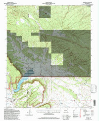
 1995 Pine Canyon1998 Print · USGSHigh desert forest and seasonal waterways define this New Mexico landscape in the mid-1990s. Researchers can trace land use at the Ford Ranch, locate the Cottonwood Gulch Camp, and study the shoreline of Bluewater Lake.
 - 1995 Map of Ciniza, 1998 Print
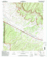
 1995 Ciniza1998 Print · USGSMid-nineties McKinley County shows an interesting overlap of heavy industry and national forest land along the Puerco River corridor. Trace the Old Railroad Grade through the canyons or locate industrial landmarks like the Ciniza Refinery and Ciniza Landing Strip.
 - 1995 Map of Cerro Parido, 1998 Print
 1995 Cerro Parido1998 Print · USGSNorthwestern New Mexico ranching country remains centered on isolated outposts and high mesas in the late twentieth century. Genealogists can trace family holdings at Sandoval Ranch and Joe Montoya Ranch or locate landmarks like Cerro Parido.
 - 1995 Map of Upper Nutria, 1998 Print
 1995 Upper Nutria1998 Print · USGSNorthwestern New Mexico in the mid-1990s reveals a landscape of high forest and traditional Zuni lands divided by a striking ridge line. Genealogists can locate family sites near Upper Nutria and Lower Nutria or trace history at Torreon Cemetery.
 - 1995 Map of Laguna Seca, 1998 Print
 1995 Laguna Seca1998 Print · USGSHigh-plateau ranching and wildlife lands in McKinley and Sandoval counties are captured here during the mid-nineties. Trace the boundaries of the Nuestra Señora de la Luz de las Lagunitas Grant and find vital water sources like Ojo Frio and Laguna Seca.
End of results
Showing maps 1-23 of 23
Top cities of McKinley County
Frequently asked questions
- What are the different types of historical maps available for McKinley County?
- What is the oldest map of McKinley County?
- Where can I purchase historical maps of McKinley County for my home or office?
- Where can I download high-res historical maps of McKinley County?
- Are there historical topographic maps available for McKinley County?
- Is there historical aerial imagery available for McKinley County?
- Where are historical maps of McKinley County sourced from?