1980s Maps of Alamogordo, New Mexico
Explore 4 historic maps of Alamogordo from the 1980s. These maps offer a rare glimpse into what life looked like during the 1980s — showing old roads, neighborhoods, homes, and landmarks that have changed or disappeared over time.
Whether you're researching your family's past, planning a metal detecting trip, or studying how Alamogordo's landscape evolved across the 1980s, these high-resolution maps are a powerful tool for exploring the history of this region.
- Focus on a specific era: All maps on this page are from the 1980s, giving you a focused view of this time period.
- See what’s changed: Compare century-old streets, trails, and buildings to today's modern landscape using overlays and satellite layers.
- Research with precision: Use these maps for genealogy, historical research, land use analysis, or educational projects.
- View, download, or print: Maps are fully viewable online in high resolution, and can be downloaded or printed for your own records.
Start exploring Alamogordo's history through authentic maps from the 1980s. This is your window into the past.
Alamogordo, NM maps
(4)- 1981 Map of Alamogordo North, 1982 Print
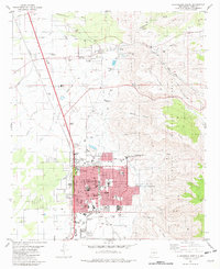 1981 Alamogordo North1982 Print · USGSAlamogordo and the historic village of La Luz are captured in the early eighties as they expanded along the base of the Sacramento Mountains. Researchers can trace local landmarks like the International Space Hall of Fame, the N M State University (Alamogordo Branch), and the old Southern Pacific line.
 - 1981 Map of Alamogordo South, 1982 Print
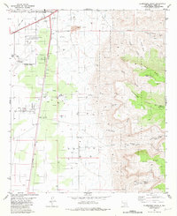 1981 Alamogordo South1982 Print · USGSThe high desert outskirts of Otero County are shown here during a period of significant regional growth and military importance. Researchers can trace the development of Boles Acres, locate the historic Southern Pacific rail line, and find mountain landmarks like Dripping Spring and Mule Peak.2 unique versions available
 - 1982 Map of Holloman
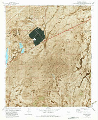 1982 Holloman1982 Print · USGSThe high desert of Otero County serves as a backdrop for the expansion of military aviation and traditional ranching in the early 1980s. Local researchers can trace the footprint of Holloman Air Force Base alongside rangeland landmarks like Harrington Tank and Huss Well.
 - 1982 Map of White Sands
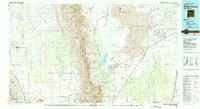 1982 White Sands1982 Print · USGSNew Mexico's high desert reveals its complex military and scientific heritage during the early eighties, from the gypsum dunes to the missile ranges. Researchers can trace the massive boundaries of White Sands National Monument and locate the White Sands Test Facility (NASA) among the rugged San Andres Mountains.
End of results
Showing maps 1-4 of 4
Top cities near Alamogordo
- Tularosa historical maps
- Boles Acres historical maps
- Alamorosa historical maps
- High Rolls historical maps
- Cloudcroft historical maps
Frequently asked questions
- What are the different types of historical maps available for Alamogordo?
- What is the oldest map of Alamogordo?
- Where can I purchase historical maps of Alamogordo for my home or office?
- Where can I download high-res historical maps of Alamogordo?
- Are there historical topographic maps available for Alamogordo?
- Is there historical aerial imagery available for Alamogordo?
- Where are historical maps of Alamogordo sourced from?