1970s Maps of Alamogordo, New Mexico
Explore 4 historic maps of Alamogordo from the 1970s. These maps offer a rare glimpse into what life looked like during the 1970s — showing old roads, neighborhoods, homes, and landmarks that have changed or disappeared over time.
Whether you're researching your family's past, planning a metal detecting trip, or studying how Alamogordo's landscape evolved across the 1970s, these high-resolution maps are a powerful tool for exploring the history of this region.
- Focus on a specific era: All maps on this page are from the 1970s, giving you a focused view of this time period.
- See what’s changed: Compare century-old streets, trails, and buildings to today's modern landscape using overlays and satellite layers.
- Research with precision: Use these maps for genealogy, historical research, land use analysis, or educational projects.
- View, download, or print: Maps are fully viewable online in high resolution, and can be downloaded or printed for your own records.
Start exploring Alamogordo's history through authentic maps from the 1970s. This is your window into the past.
Alamogordo, NM maps
(4)- 1976 Map of Mule Peak, 1980 Print
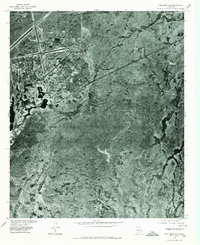
 1976 Mule Peak1980 Print · USGSThe high desert of Otero County is captured in this 1970s orthophoto as rail and road corridors skirt the mountain front. Researchers can trace the development of Omlee and the stark drainage patterns of Mule Canyon and Dog Canyon.
 - 1976 Map of Holloman SE, 1980 Print
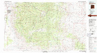
 1976 Holloman SE1980 Print · USGSOtero County's high desert landscape was evolving in the mid-seventies as military aviation expanded across the Tularosa Basin. Trace the structural layout of Holloman Air Force Base, from its intricate runway networks to its specialized desert housing and support facilities.
 - 1976 Map of Alamogordo, 1980 Print
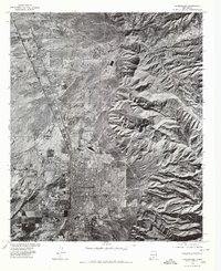 1976 Alamogordo1980 Print · USGSThe high desert plains of Otero County are frozen in the mid-seventies, showing the urban footprint of Alamogordo against the mountain front. Researchers can trace the development of La Luz and the rugged drainage patterns of Dry Canyon and Marble Canyon.
 - 1979 Map of Alamogordo
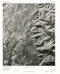
 1979 Alamogordo1979 Print · USGSThe high Sacramento Mountains and the Tularosa Valley floor meet in the late seventies, showing the region's unique mix of scientific research and military land use. Genealogists and historians can trace routes to Cloudcroft, the Solar Observatory, and the McGregor Range.
End of results
Showing maps 1-4 of 4
Top cities near Alamogordo
- Tularosa historical maps
- Boles Acres historical maps
- Alamorosa historical maps
- High Rolls historical maps
- Cloudcroft historical maps
Frequently asked questions
- What are the different types of historical maps available for Alamogordo?
- What is the oldest map of Alamogordo?
- Where can I purchase historical maps of Alamogordo for my home or office?
- Where can I download high-res historical maps of Alamogordo?
- Are there historical topographic maps available for Alamogordo?
- Is there historical aerial imagery available for Alamogordo?
- Where are historical maps of Alamogordo sourced from?