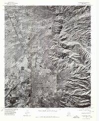
1976 Map of Alamogordo
USGS Topo · Published 1980About this map
Alamogordo and the neighboring settlement of La Luz are captured in this mid-1970s orthophotoquad, which uses rectified aerial imagery to reveal the precise layout of the community at the base of the Sacramento Mountains. The dense grid of the city's residential and commercial districts contrasts sharply with the stark, alluvial fan topography to the east. The drainage patterns of Dry Canyon, Beeman Canyon, and Marble Canyon are visible as they cut through the steep escarpment, illustrating the geological forces that define the local geography. Produced in cooperation with the Soil Conservation Service, this imagery provides a clear look at the extent of land development and agricultural activity on the high desert plains before the expansions of the late 20th century.
Find a feature on this map
5 named features on this map. Tap any name to fly to it.
Don’t see what you’re looking for? This feature index may not catch every label — zoom into the map to look around manually.
Map Details
Editions of this 1976 Alamogordo Map
This is the sole edition of this map. No revisions or reprints were ever made.
Other maps of this area

1916 · Tularosa
USGS Topo · 1:125,000

1916 · Point Of Sands
USGS Topo · 1:125,000

1948 · Tularosa
USGS Topo · 1:62,500

1948 · Holloman
USGS Topo · 1:62,500

1950 · Alamogordo
USGS Topo · 1:62,500

1950 · Mescalero
USGS Topo · 1:62,500

1954 · Carlsbad
USGS Topo · 1:250,000

1954 · Tularosa
USGS Topo · 1:250,000

1955 · Las Cruces
USGS Topo · 1:250,000

1955 · Roswell
USGS Topo · 1:250,000