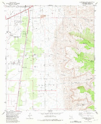
1981 Map of Alamogordo South
USGS Topo · Published 1982About this map
Alamogordo and its surrounding desert basin meet the steep ascent of the Sacramento Mountains in this early 1980s landscape. The settlement pattern shows the city's southward expansion toward Boles Acres and Omlee, heavily influenced by the presence of Holloman Air Force Base and the Alamogordo-White Sands Regional Airport. Connectivity is defined by the Southern Pacific railroad and a network of pipelines and aqueducts that sustain the community against the arid terrain of the Tularosa Basin.
Find a feature on this map
46 named features on this map. Tap any name to fly to it.
Don’t see what you’re looking for? This feature index may not catch every label — zoom into the map to look around manually.
Map Details
Editions of this 1981 Alamogordo South Map
2 editions found
Other maps of this area

1916 · Point Of Sands
USGS Topo · 1:125,000

1948 · Tres Hermanos
USGS Topo · 1:62,500

1948 · Holloman
USGS Topo · 1:62,500

1950 · Escondido Canyon
USGS Topo · 1:62,500

1950 · Alamogordo
USGS Topo · 1:62,500

1954 · Carlsbad
USGS Topo · 1:250,000

1955 · Las Cruces
USGS Topo · 1:250,000

1958 · Las Cruces
USGS Topo · 1:250,000

1958 · Carlsbad
USGS Topo · 1:250,000

1976 · Mule Peak
USGS Topo · 1:24,000