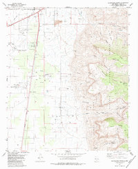
1981 Map of Alamogordo South
USGS Topo · Published 1984About this map
Alamogordo expands southward toward the Tularosa Basin floor, where the Southern Pacific railroad and highway corridors dictate the layout of industrial sites and residential pockets. The landscape is defined by the sharp transition from the desert plains to the western slopes of the Sacramento Mountains, protected within the Lincoln National Forest. While the western half of the sheet shows modern development like the Alamogordo-White Sands Regional Airport and Boles Acres, the eastern mountain slopes remain punctuated by historic water sources such as Dripping Spring and Hackberry Spring. These springs and several Pack Trails winding through Alamo Canyon and Muleshoe Canyon highlight the era's reliance on established mountain routes for recreation and ranching. The presence of a Drive-in Theater and numerous Gravel Pits reflects the mid-century growth and entertainment culture of Otero County.
Find a feature on this map
42 named features on this map. Tap any name to fly to it.
Don’t see what you’re looking for? This feature index may not catch every label — zoom into the map to look around manually.
Map Details
Editions of this 1981 Alamogordo South Map
2 editions found
Other maps of this area

1916 · Point Of Sands
USGS Topo · 1:125,000

1948 · Tres Hermanos
USGS Topo · 1:62,500

1948 · Holloman
USGS Topo · 1:62,500

1950 · Escondido Canyon
USGS Topo · 1:62,500

1950 · Alamogordo
USGS Topo · 1:62,500

1954 · Carlsbad
USGS Topo · 1:250,000

1955 · Las Cruces
USGS Topo · 1:250,000

1958 · Las Cruces
USGS Topo · 1:250,000

1958 · Carlsbad
USGS Topo · 1:250,000

1976 · Mule Peak
USGS Topo · 1:24,000