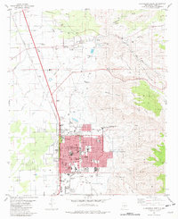
1981 Map of Alamogordo North
USGS Topo · Published 1982About this map
The northern reaches of Alamogordo sit at the foot of the Sacramento Mountains, where the high desert floor meets the rising slopes of the Lincoln National Forest. This era of growth is defined by a dense network of educational and institutional landmarks, including the N M School for Visually Handicapped and the International Space Hall of Fame, reflecting the town's connection to aerospace history and state services. To the north, the settlement of La Luz remains a distinct community, bounded by Luz Creek and the La Luz Speedway. The landscape is etched with the transition from rail to road, with the Southern Pacific tracks running parallel to an Old Railroad Grade that winds through Dry Canyon. Infrastructure such as the Aqueduct and numerous Water Tanks trace the essential management of water across the alluvial fans of Burro Flats.
Find a feature on this map
64 named features on this map. Tap any name to fly to it.
Don’t see what you’re looking for? This feature index may not catch every label — zoom into the map to look around manually.
Map Details
Editions of this 1981 Alamogordo North Map
This is the sole edition of this map. No revisions or reprints were ever made.
Other maps of this area

1916 · Tularosa
USGS Topo · 1:125,000

1916 · Point Of Sands
USGS Topo · 1:125,000

1948 · Tularosa
USGS Topo · 1:62,500

1948 · Holloman
USGS Topo · 1:62,500

1950 · Alamogordo
USGS Topo · 1:62,500

1950 · Mescalero
USGS Topo · 1:62,500

1954 · Carlsbad
USGS Topo · 1:250,000

1954 · Tularosa
USGS Topo · 1:250,000

1955 · Las Cruces
USGS Topo · 1:250,000

1955 · Roswell
USGS Topo · 1:250,000