1960s Maps of Timberon, New Mexico
Explore 2 historic maps of Timberon from the 1960s. These maps offer a rare glimpse into what life looked like during the 1960s — showing old roads, neighborhoods, homes, and landmarks that have changed or disappeared over time.
Whether you're researching your family's past, planning a metal detecting trip, or studying how Timberon's landscape evolved across the 1960s, these high-resolution maps are a powerful tool for exploring the history of this region.
- Focus on a specific era: All maps on this page are from the 1960s, giving you a focused view of this time period.
- See what’s changed: Compare century-old streets, trails, and buildings to today's modern landscape using overlays and satellite layers.
- Research with precision: Use these maps for genealogy, historical research, land use analysis, or educational projects.
- View, download, or print: Maps are fully viewable online in high resolution, and can be downloaded or printed for your own records.
Start exploring Timberon's history through authentic maps from the 1960s. This is your window into the past.
Timberon, NM maps
(2)- 1965 Map of Rogers Ruins, 1968 Print
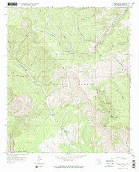 1965 Rogers Ruins1968 Print · USGSOtero County ranching and forest lands are documented here in the mid-sixties, showing the high-country landscape before modern development. Genealogists and hikers can trace old family holdings like Circle Cross Ranch or locate the namesake Rogers Ruins.
 - 1965 Map of El Paso Canyon, 1968 Print
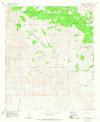 1965 El Paso Canyon1968 Print · USGSOtero County, New Mexico, is depicted here in the mid-1960s at the intersection of federal forest and military lands. Researchers can trace the rugged boundaries of the Fort Bliss Military Reservation and find remote landmarks like Gulp Peak and Womack Tank.2 unique versions available
End of results
Showing maps 1-2 of 2
Top cities near Timberon
Frequently asked questions
- What are the different types of historical maps available for Timberon?
- What is the oldest map of Timberon?
- Where can I purchase historical maps of Timberon for my home or office?
- Where can I download high-res historical maps of Timberon?
- Are there historical topographic maps available for Timberon?
- Is there historical aerial imagery available for Timberon?
- Where are historical maps of Timberon sourced from?