
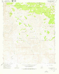
1965 Map of El Paso Canyon
USGS Topo · Published 1968About this map
The Fort Bliss Military Reservation dominates the southern half of this landscape, its boundary cutting across the rugged canyons and ridges of Otero County. To the north, the terrain transitions into the Lincoln National Forest, where high elevations are marked by landmarks like Gulp Peak and the drainage of the Sacramento River. This mid-1960s survey captures a dry, high-altitude environment defined by complex water-management features, including the Rim Tank, Womack Tank, and Sombrero Tank, which are essential for livestock and wildlife in a region otherwise dominated by seasonal washes. A network of primitive transport routes, labeled as Jeep Trail, weaves through the steep drainages of El Paso Canyon and Wildcat Canyon, illustrating the remote nature of this military and forest land before significant modern development.
Find a feature on this map
17 named features on this map. Tap any name to fly to it.
Don’t see what you’re looking for? This feature index may not catch every label — zoom into the map to look around manually.
Map Details
Editions of this 1965 El Paso Canyon Map
2 editions found
Other maps of this area

1943 · Pendejo Wash
USGS Topo · 1:62,500

1950 · Escondido Canyon
USGS Topo · 1:62,500

1954 · Carlsbad
USGS Topo · 1:250,000

1958 · Carlsbad
USGS Topo · 1:250,000

1965 · Bear Spring
USGS Topo · 1:24,000

1965 · Surveyors Canyon
USGS Topo · 1:24,000

1965 · Rogers Ruins
USGS Topo · 1:24,000

1979 · Alamogordo
USGS Topo · 1:100,000

1979 · Crow Flats
USGS Topo · 1:100,000
1980 · El Paso Draw
USGS Topo · 1:24,000