1930s Maps of San Juan County, New Mexico
Explore 7 historic maps of San Juan County from the 1930s. These maps offer a rare glimpse into what life looked like during the 1930s — showing old roads, neighborhoods, homes, and landmarks that have changed or disappeared over time.
Whether you're researching your family's past, planning a metal detecting trip, or studying how San Juan County's landscape evolved across the 1930s, these high-resolution maps are a powerful tool for exploring the history of this region.
- Focus on a specific era: All maps on this page are from the 1930s, giving you a focused view of this time period.
- See what’s changed: Compare century-old streets, trails, and buildings to today's modern landscape using overlays and satellite layers.
- Research with precision: Use these maps for genealogy, historical research, land use analysis, or educational projects.
- View, download, or print: Maps are fully viewable online in high resolution, and can be downloaded or printed for your own records.
Start exploring San Juan County's history through authentic maps from the 1930s. This is your window into the past.
San Juan County, NM maps
(7)- 1932 Map of Kirtland
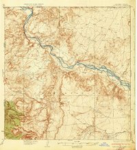
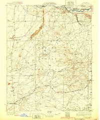 1932 Kirtland1932 Print · USGSThe Navajo Nation's high desert landscape and the San Juan River valley are documented here in the early thirties. Genealogists and historians can trace essential early hubs like the Wheeler Trading Post, the Oil Pumping Sta near Barber Peak, and the community at Fruitland.
 - 1934 Map of Ship Rock, 1955 Print
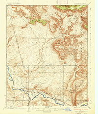
 1934 Ship Rock1955 Print · USGSThe high desert of San Juan County during the mid-1930s is revealed through this detailed topographic survey of the Navajo Nation. Geologists and local historians can trace the paths of the Red Rock Highway or locate water sources like Sheep Spring and Mud Spring.4 unique versions available
 - 1934 Map of Chimney Rock, 1967 Print
 1934 Chimney Rock1967 Print · USGSThe Navajo and Southern Ute borders met along the San Juan River in the mid-1930s, creating a crossroads of tribal administration and desert agriculture. Genealogists and historians can locate the Shiprock Indian Agency, the Agency Coal Mine, and the path of the Old Mormon Trail.
 - 1934 Map of Rattlesnake, 1971 Print
 1934 Rattlesnake1971 Print · USGSThe San Juan River basin and the Four Corners intersection are captured here in the mid-1930s. Researchers can trace the early road networks and small settlements of the Navajo Indian Reservation, including Rattlesnake, Cudai, and Bitlabito.
 - 1936 Map of Chimney Rock
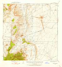
 1936 Chimney Rock1936 Print · USGSThe Navajo and Southern Ute borders met along the San Juan River in the mid-1930s, showing a landscape defined by both geologic wonders and early industry. Trace the path of the Old Mormon Trail or locate early coal operations at the Agency Coal Mine.2 unique versions available
 - 1937 Map of Ship Rock
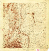 1937 Ship Rock1937 Print · USGSThe Navajo Nation territory comes into focus in the mid-1930s, centered on the towering geological monadnock and the high-plateau borderlands. Trace early travel routes like the Red Rock Highway past isolated landmarks including Mitten Rock and Mud Spring.4 unique versions available
 - 1937 Map of Rattlesnake
 1937 Rattlesnake1937 Print · USGSThe high desert borderlands where New Mexico meets Colorado and Arizona are captured here in the mid-1930s. Researchers can trace early reservation life near the San Juan River and locate historic points like Bitlabito, Cudai, and Rattlesnake.3 unique versions available
End of results
Showing maps 1-7 of 7
Top cities of San Juan County
Frequently asked questions
- What are the different types of historical maps available for San Juan County?
- What is the oldest map of San Juan County?
- Where can I purchase historical maps of San Juan County for my home or office?
- Where can I download high-res historical maps of San Juan County?
- Are there historical topographic maps available for San Juan County?
- Is there historical aerial imagery available for San Juan County?
- Where are historical maps of San Juan County sourced from?