1950s Maps of Santa Fe County, New Mexico
Explore 34 historic maps of Santa Fe County from the 1950s. These maps offer a rare glimpse into what life looked like during the 1950s — showing old roads, neighborhoods, homes, and landmarks that have changed or disappeared over time.
Whether you're researching your family's past, planning a metal detecting trip, or studying how Santa Fe County's landscape evolved across the 1950s, these high-resolution maps are a powerful tool for exploring the history of this region.
- Focus on a specific era: All maps on this page are from the 1950s, giving you a focused view of this time period.
- See what’s changed: Compare century-old streets, trails, and buildings to today's modern landscape using overlays and satellite layers.
- Research with precision: Use these maps for genealogy, historical research, land use analysis, or educational projects.
- View, download, or print: Maps are fully viewable online in high resolution, and can be downloaded or printed for your own records.
Start exploring Santa Fe County's history through authentic maps from the 1950s. This is your window into the past.
Santa Fe County, NM maps
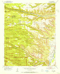
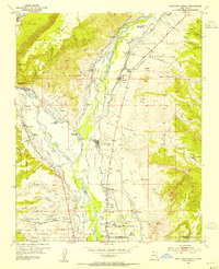
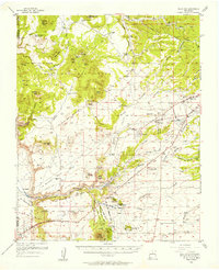
(34)- 1951 Map of Agua Fria, 1953 Print
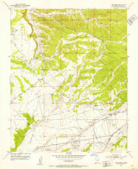 1951 Agua Fria1953 Print · USGSThe area west of the state capital is captured in the early fifties as old land grants met mid-century aviation and highway growth. Trace family history at San Isidro Cemetery or follow the historic path of El Camino Real and Agua Fria.7 unique versions available
 - 1951 Map of Turquoise Hill, 1987 Print
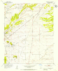
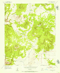
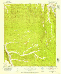
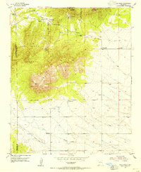
 1951 Turquoise Hill1987 Print · USGSSanta Fe's high-desert outskirts appear in the mid-fifties, showing a mix of Spanish land grants and emerging state infrastructure. Genealogists and researchers can find old community landmarks like St Joseph Church, the Cienega School, and the Marshal Bonanza Mine.
 - 1952 Map of Santa Fe, 1953 Print
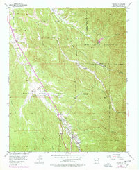
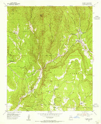
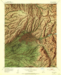 1952 Santa Fe1953 Print · USGSSanta Fe is shown mid-century just as its cultural and civic footprint began to expand beyond the traditional plaza area. Local historians can trace the grounds of the Brun General Hospital, Rosario Cem, and the path of the Atchison Topeka and Santa Fe railroad.4 unique versions available
 - 1952 Map of Turquoise Hill, 1953 Print
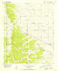
 1952 Turquoise Hill1953 Print · USGSThe high desert southwest of Santa Fe in the early fifties shows a landscape of historic land grants and growing aviation infrastructure. Genealogists and historians can trace the foundations of local life at St Joseph Church, the Marshal Bonanza Mine, and along the historic El Camino Real.3 unique versions available
 - 1952 Map of Seton Village, 1953 Print
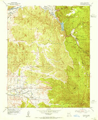
 1952 Seton Village1953 Print · USGSSouth of Santa Fe in the early fifties, this landscape is defined by vast historic land grants and the steel of the railroad. Researchers can trace the borders of the Bishop John Lamy Grant or locate old outposts like Ninemile Ranch and Gallina Camp.5 unique versions available
 - 1952 Map of White Rock, 1954 Print
 1952 White Rock1954 Print · USGSThe high mesas of Los Alamos and Santa Fe counties are captured here in the early fifties, documenting the remote canyon systems and early utility networks. Genealogists and historians can trace land grant boundaries and find markers of early industry like the Old Railroad Grade and Totavi.3 unique versions available
 - 1952 Map of Puye, 1954 Print
 1952 Puye1954 Print · USGSThe Pajarito Plateau in the early fifties reveals a landscape of deep canyons and ancient heritage. Researchers can locate archaeological sites like the Cliff Dwellings at Puye or trace the early industrial footprint of the General Pumice Mine.4 unique versions available
 - 1952 Map of Montoso Peak, 1954 Print
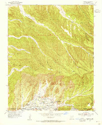
 1952 Montoso Peak1954 Print · USGSSanta Fe County’s high plateau is captured here in the early fifties, dominated by the historic Caja Del Rio Grant and its network of arroyos. Researchers can trace early water management and land use through Rito Reservoir, Eleven Hundred Well, and the Department of Agriculture Experimental Area.4 unique versions available
 - 1953 Map of Tesuque
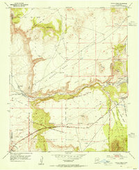
 1953 Tesuque1953 Print · USGSNorth of Santa Fe in the early fifties, the high-desert landscape reveals a convergence of historic land grants and Pueblo life. Genealogists and historians can locate community centers like San Diego Ch, the Tesuque Pueblo Day Sch, and Rancho del Monte.6 unique versions available
 - 1953 Map of Espanola, 1954 Print
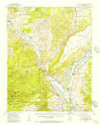
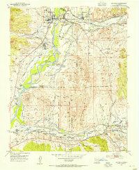 1953 Espanola1954 Print · USGSThe Tewa Basin in the early fifties shows a valley structured by ancient land grants and river-fed irrigation. Researchers can trace ancestral boundaries and local landmarks like Santa Clara Pueblo, the Black Mesa Church, and the McCurdy Sch.3 unique versions available
 - 1953 Map of San Juan Pueblo, 1954 Print
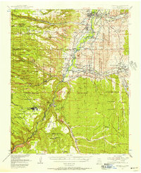
 1953 San Juan Pueblo1954 Print · USGSThe Rio Grande and Chama river valleys in the mid-1950s show a blend of Pueblo life and Spanish colonial heritage. Researchers can trace ancestral lands and mission chapels like Capilla de San Pedro or the historic site of the Old San Juan First Spanish Capitol 1598.4 unique versions available
 - 1953 Map of Horcado Ranch, 1954 Print
 1953 Horcado Ranch1954 Print · USGSNorthern Santa Fe County in the early fifties shows a landscape of historic land grants and early transport. Trace the Old Chili Line Railroad Grade and the settlement at Cuyamungue near the Rio Tesuque.5 unique versions available
 - 1953 Map of Tetilla Peak, 1954 Print
 1953 Tetilla Peak1954 Print · USGSSanta Fe County in the early fifties shows a rugged landscape defined by historic Spanish land grants and the steep drop of La Bajada Mesa. Researchers can trace the path of El Camino Real, locate the Tsinat Ruins, and find the remote Turquoise Trading Post.5 unique versions available
 - 1953 Map of Truchas, 1955 Print
 1953 Truchas1955 Print · USGSNorthern New Mexico's high-altitude villages and traditional land grants are meticulously documented during the mid-century. Researchers can trace historic acequias and property lines within the Las Trampas Grant or locate ancestral sites in Truchas, Cordova, and Ojo Sarco.4 unique versions available
 - 1953 Map of Sierra Mosca, 1955 Print
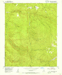 1953 Sierra Mosca1955 Print · USGSThe high Sangre de Cristo foothills come alive in the early fifties, showing a remote landscape shaped by deep canyons and ancient boundaries. Trace the mountain paths of the Borrego Trail past Agua Sarca Cabin and the peak of Sierra Mosca.6 unique versions available
 - 1953 Map of Glorieta, 1955 Print
 1953 Glorieta1955 Print · USGSSanta Fe County at the start of the 1950s shows a landscape where historic trails and modern rails meet in the mountains. Trace the route of the Santa Fe Trail, locate family holdings like Gonzales Ranch, and identify the Glorieta Battlefield Site.6 unique versions available
 - 1953 Map of Cundiyo, 1955 Print
 1953 Cundiyo1955 Print · USGSSanta Fe County in the early fifties reveals a landscape defined by historic land grants and Pueblo life. Researchers can trace the layout of Nambe Pueblo, the pilgrimage site of Santuario, and the isolated Cundiyo along the river valleys.3 unique versions available
 - 1953 Map of Chimayo, 1955 Print
 1953 Chimayo1955 Print · USGSNorthern New Mexico in the early fifties shows a landscape of traditional land grants and scattered valley settlements. Trace genealogies through Chimayo, Los Pachecos, and Quemado or locate historic sites like Capilla de Santa Rita and ancient Pueblo Ruins.3 unique versions available
 - 1953 Map of Mc Clure Reservoir, 1955 Print
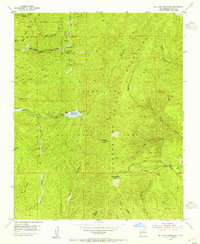 1953 Mc Clure Reservoir1955 Print · USGSThe high peaks east of Santa Fe are documented here in the early fifties, showing the vital water infrastructure and land grants of the region. Local historians can trace the Juan de Gabaldon Grant boundaries or locate the Glorieta Baldy Lookout Station.5 unique versions available
 - 1953 Map of Agua Fria, 1956 Print
 1953 Agua Fria1956 Print · USGSSanta Fe and the surrounding mesas in the mid-1950s reveal a mix of ancient Puebloan history and mid-century modern growth. Trace the path of El Camino Real, locate family roots near La Bajada, or find mining history at the Marshal Bonanza Mine.
 - 1953 Map of San Juan Pueblo, 1956 Print
 1953 San Juan Pueblo1956 Print · USGSRio Arriba County life in the mid-fifties is centered on the fertile confluence of the Rio Chama and Rio Grande. Local history researchers can trace ancestral roots through the numerous land grants, old irrigation Ditch lines, and early sites like San Juan Pueblo, Hernandez, and Los Luceros.2 unique versions available
 - 1953 Map of Espanola, 1958 Print
 1953 Espanola1958 Print · USGSNorthern New Mexico in the early fifties shows a landscape of deep canyons and ancestral Pueblo lands along the RIO GRANDE. Genealogists and historians can trace family-named sites like Evans Ranch or locate ancient Cliff Dwellings and the Old Railroad Grade.3 unique versions available
 - 1953 Map of Aspen Basin, 1963 Print
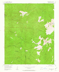 1953 Aspen Basin1963 Print · USGSThe Sangre de Cristo Mountains north of Santa Fe are shown here in the early fifties, featuring the rugged high-country headwaters of the Santa Fe River. Trace the old trails and backcountry outposts of the era, from Rancho Viejo and Aspen Ranch to the Sierra Lodge.6 unique versions available
 - 1954 Map of San Pedro, 1955 Print
 1954 San Pedro1955 Print · USGSSanta Fe County's high-elevation ranching and mining country is captured here in the mid-fifties, just as older infrastructure was fading into the landscape. Trace family history at San Pedro Cemetery or follow the Old Railroad Grade past Cedar Grove.3 unique versions available
 - 1954 Map of Edgewood, 1955 Print
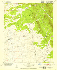
 1954 Edgewood1955 Print · USGSMid-century Santa Fe County is captured here as a landscape of family ranching and early transit corridors. Genealogists and historians can trace the foundations of Edgewood through named landmarks like Mountain Valley Cemetery and the Old Railroad Grade.3 unique versions available
Showing maps 1-25 of 34
Top cities of Santa Fe County
- Santa Fe historical maps
- Edgewood historical maps
- Santa Cruz historical maps
- Madrid historical maps
- Lamy historical maps
Frequently asked questions
- What are the different types of historical maps available for Santa Fe County?
- What is the oldest map of Santa Fe County?
- Where can I purchase historical maps of Santa Fe County for my home or office?
- Where can I download high-res historical maps of Santa Fe County?
- Are there historical topographic maps available for Santa Fe County?
- Is there historical aerial imagery available for Santa Fe County?
- Where are historical maps of Santa Fe County sourced from?