1980s Maps of Santa Fe County, New Mexico
Explore 8 historic maps of Santa Fe County from the 1980s. These maps offer a rare glimpse into what life looked like during the 1980s — showing old roads, neighborhoods, homes, and landmarks that have changed or disappeared over time.
Whether you're researching your family's past, planning a metal detecting trip, or studying how Santa Fe County's landscape evolved across the 1980s, these high-resolution maps are a powerful tool for exploring the history of this region.
- Focus on a specific era: All maps on this page are from the 1980s, giving you a focused view of this time period.
- See what’s changed: Compare century-old streets, trails, and buildings to today's modern landscape using overlays and satellite layers.
- Research with precision: Use these maps for genealogy, historical research, land use analysis, or educational projects.
- View, download, or print: Maps are fully viewable online in high resolution, and can be downloaded or printed for your own records.
Start exploring Santa Fe County's history through authentic maps from the 1980s. This is your window into the past.
Santa Fe County, NM maps
(8)- 1983 Map of Taos
 1983 Taos1983 Print · USGSNorthern New Mexico's high-country heritage is on full display in the early eighties, from the deep river canyons to the highest alpine peaks. Genealogists and historians can trace traditional land-grant settlements like Las Trampas, Truchas, and the historic Taos Pueblo.2 unique versions available
 - 1983 Map of Albuquerque, 1984 Print
 1983 Albuquerque1984 Print · USGSCentral New Mexico in the early eighties shows a landscape where ancient pueblos and modern aerospace hubs meet. Trace the routes of the Atchison Topeka and Santa Fe RR or locate landmarks like Kirtland Air Force Base, Madrid, and the Sandia Mountains.
 - 1983 Map of Santa Fe, 1984 Print
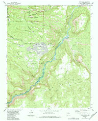
 1983 Santa Fe1984 Print · USGSThe high Sangre de Cristo Mountains and the growing state capital define this early 1980s landscape during a period of expanding infrastructure. Researchers can trace historic land patterns and transit routes from Nambe Pueblo and Glorieta Pass to the Atchison Topeka and Santa Fe RR line.
 - 1983 Map of Villanueva, 1984 Print
 1983 Villanueva1984 Print · USGSThe Pecos River valley and its high mesa surroundings are captured here in the early eighties. Researchers can trace historic river settlements like Villanueva and Sena, the route of the Atchison Topeka and Santa Fe railroad, and the high-desert terrain of Glorieta Mesa.
 - 1984 Map of White Rock
 1984 White Rock1984 Print · USGSLos Alamos County was undergoing significant residential growth in the mid-eighties as modern neighborhoods expanded atop the mesas. Local historians can trace ancestral sites like Tsankawi Ruins and Tshirege Ruins or follow the Old Railroad Grade along the Rio Grande.2 unique versions available
 - 1984 Map of Espanola
 1984 Espanola1984 Print · USGSIn the mid-1980s, this area of the Rio Grande valley remained a landscape of historic pueblos and vital irrigation ditches. Genealogists and historians can trace the community layouts of Santa Clara Pueblo, La Mesilla, and Jacona alongside the rising landmark of Black Mesa.2 unique versions available
 - 1986 Map of King Draw
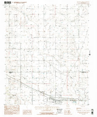
 1986 King Draw1986 Print · USGSSanta Fe County in the mid-1980s is captured here in a moment of quiet rural utility. Local researchers can trace the settlement at Hyer and find remote landmarks like the Gravel Pit, a Landing Strip, and the winding paths of King Draw.
 - 1986 Map of Moriarty North
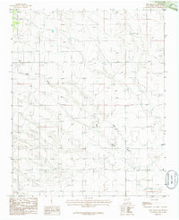
 1986 Moriarty North1986 Print · USGSThe high plains of Santa Fe and Torrance counties come into focus during the mid-1980s. Genealogists and historians can trace the development of Moriarty, locate the Old Railroad Grade, and find smaller outposts like Otto amidst the network of ranch roads.2 unique versions available
End of results
Showing maps 1-8 of 8
Top cities of Santa Fe County
- Santa Fe historical maps
- Edgewood historical maps
- Santa Cruz historical maps
- Madrid historical maps
- Lamy historical maps
Frequently asked questions
- What are the different types of historical maps available for Santa Fe County?
- What is the oldest map of Santa Fe County?
- Where can I purchase historical maps of Santa Fe County for my home or office?
- Where can I download high-res historical maps of Santa Fe County?
- Are there historical topographic maps available for Santa Fe County?
- Is there historical aerial imagery available for Santa Fe County?
- Where are historical maps of Santa Fe County sourced from?