1990s Maps of Santa Fe County, New Mexico
Explore 14 historic maps of Santa Fe County from the 1990s. These maps offer a rare glimpse into what life looked like during the 1990s — showing old roads, neighborhoods, homes, and landmarks that have changed or disappeared over time.
Whether you're researching your family's past, planning a metal detecting trip, or studying how Santa Fe County's landscape evolved across the 1990s, these high-resolution maps are a powerful tool for exploring the history of this region.
- Focus on a specific era: All maps on this page are from the 1990s, giving you a focused view of this time period.
- See what’s changed: Compare century-old streets, trails, and buildings to today's modern landscape using overlays and satellite layers.
- Research with precision: Use these maps for genealogy, historical research, land use analysis, or educational projects.
- View, download, or print: Maps are fully viewable online in high resolution, and can be downloaded or printed for your own records.
Start exploring Santa Fe County's history through authentic maps from the 1990s. This is your window into the past.
Santa Fe County, NM maps
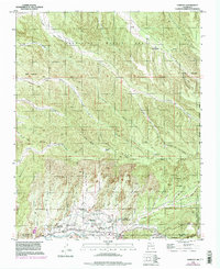
(14)- 1990 Map of Picture Rock
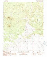
 1990 Picture Rock1990 Print · USGSNew Mexico's high desert reveals its complex mining and indigenous history in the final decades of the twentieth century. Genealogists and historians can trace old prospects near Mount Chalchihuitl, the historic Cerrillos settlement, and the site of the San Marcos Pueblo.
 - 1990 Map of Longhorn Reservoir
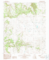
 1990 Longhorn Reservoir1990 Print · USGSThe border of Santa Fe and Torrance counties is captured here in the final decade of the century, showing a landscape shaped by water management and ranching. Researchers can locate the Longhorn Ranch, trace the winding Armijo Draw, and find local landmarks like Stinking Spring and a solitary Grave.
 - 1990 Map of White Lakes
 1990 White Lakes1990 Print · USGSSanta Fe County ranching and utility infrastructure are documented in the late twentieth century. Genealogists and researchers can trace local landmarks like Bozier Well, family-named features such as Armijo Draw, and the seasonal basins of the White Lakes.
 - 1990 Map of Madrid
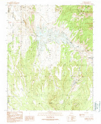 1990 Madrid1990 Print · USGSAt the close of the twentieth century, this Santa Fe County landscape shows a region shaped by mining and rail. Genealogists and historians can trace the Madrid Cem and old transportation routes like the Old Railroad Grade near Cerrillos.
 - 1990 Map of El Cuervo Butte
 1990 El Cuervo Butte1990 Print · USGSHigh desert ranching and water management define the landscape along the Santa Fe and Torrance County line in the late twentieth century. Genealogists and local historians can trace the settlement of Osita and natural features like El Cuervo Butte or Dinosaur Tank.
 - 1990 Map of Stanley
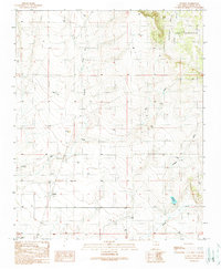 1990 Stanley1990 Print · USGSStanley and the surrounding Santa Fe County high desert are captured here as they appeared in the 1990s. Genealogists and local historians can trace the foundations of this ranching community through landmarks like Stanley Cemetery and Landon Windmill.
 - 1990 Map of Captain Davis Mountain
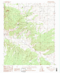
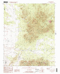
 1990 Captain Davis Mountain1990 Print · USGSThe Ortiz Mountains and surrounding high mesas come into focus during the late twentieth century, showing a landscape shaped by mining and cattle ranching. Researchers can trace the layout of the Dolores Mine, the remote Bullmill Camp, and landmarks like Captain Davis Mountain.
 - 1990 Map of Golden
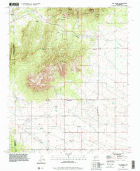
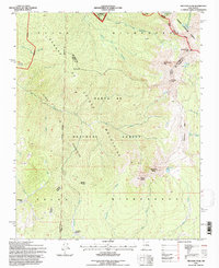
 1990 Golden1990 Print · USGSSanta Fe County mining history is preserved on this 1990 map of the Ortiz and San Pedro Mountains. Genealogists and historians can trace the foundations of Golden, locate the Old Ortiz Mine, and find the remote Boxcar Camp and Cem.2 unique versions available
 - 1990 Map of San Pedro, 1996 Print
 1990 San Pedro1996 Print · USGSThe Santa Fe and Bernalillo county line runs through this rugged mining and ranching district during the late twentieth century. Researchers can trace the Old Stagecoach Road, locate family burials at San Pedro Cemetery, and find legacy sites like Cedar Grove.
 - 1990 Map of Edgewood, 1996 Print
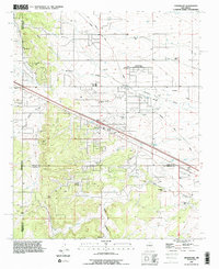 1990 Edgewood1996 Print · USGSEdgewood and the surrounding high plains were transitioning from ranching to residential use in the 1990s. Researchers can trace family-named sites like Blackwell Place, visit the Mountain Valley Cemetery, or follow the Old Railroad Grade.
 - 1994 Map of Chimayo, 1998 Print
 1994 Chimayo1998 Print · USGSThe northern New Mexico valley and its ancestral land grants are captured here during the mid-nineties. You can trace early settlement patterns and irrigation history through features like the Santa Cruz Ditch, the Capilla de Santa Rita, and several Pueblo Ruins.
 - 1995 Map of El Valle, 1997 Print
 1995 El Valle1997 Print · USGSNorthern New Mexico's traditional mountain villages and communal land grants are preserved here in the late twentieth century. Genealogists can trace family holdings like Tafoya Ranch or the historical village of El Valle alongside the high ridges of Jicarilla Peak.
 - 1995 Map of Truchas Peak, 1997 Print
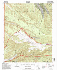
 1995 Truchas Peak1997 Print · USGSThe high peaks of the Sangre de Cristo Mountains are captured here in the mid-1990s, where three national forests and several county lines converge. Hikers and historians can trace the high-altitude Trailriders Wall, locate Pecos Falls, or find the secluded Jose Vigil Lake.
 - 1995 Map of Truchas, 1997 Print
 1995 Truchas1997 Print · USGSHigh in the Sangre de Cristo Mountains during the mid-nineties, these traditional Hispanic villages remain centered around centuries-old land grant boundaries. Genealogists and historians can trace family locations in Truchas and Cordova or find the Trampas Cemetery near the county line.
End of results
Showing maps 1-14 of 14
Top cities of Santa Fe County
- Santa Fe historical maps
- Edgewood historical maps
- Santa Cruz historical maps
- Madrid historical maps
- Lamy historical maps
Frequently asked questions
- What are the different types of historical maps available for Santa Fe County?
- What is the oldest map of Santa Fe County?
- Where can I purchase historical maps of Santa Fe County for my home or office?
- Where can I download high-res historical maps of Santa Fe County?
- Are there historical topographic maps available for Santa Fe County?
- Is there historical aerial imagery available for Santa Fe County?
- Where are historical maps of Santa Fe County sourced from?