1930s Maps of Sierra County, New Mexico
Explore 2 historic maps of Sierra County from the 1930s. These maps offer a rare glimpse into what life looked like during the 1930s — showing old roads, neighborhoods, homes, and landmarks that have changed or disappeared over time.
Whether you're researching your family's past, planning a metal detecting trip, or studying how Sierra County's landscape evolved across the 1930s, these high-resolution maps are a powerful tool for exploring the history of this region.
- Focus on a specific era: All maps on this page are from the 1930s, giving you a focused view of this time period.
- See what’s changed: Compare century-old streets, trails, and buildings to today's modern landscape using overlays and satellite layers.
- Research with precision: Use these maps for genealogy, historical research, land use analysis, or educational projects.
- View, download, or print: Maps are fully viewable online in high resolution, and can be downloaded or printed for your own records.
Start exploring Sierra County's history through authentic maps from the 1930s. This is your window into the past.
Sierra County, NM maps
(2)- 1932 Map of Tonuco
 1932 Tonuco1932 Print · USGSThe high desert of southern New Mexico appears here as a land of isolated ranches and railroad sidings in the early 1930s. Genealogists and historians can trace family-named outposts like Detroit Ranch and Ritch Ranch or follow the A. T. & S. F. line past Aleman.
 - 1935 Map of Hillsboro
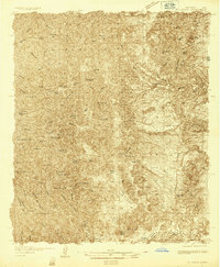 1935 Hillsboro1935 Print · USGSHillsboro and Kingston are documented here in the mid-1930s, surrounded by the busy mining and ranching country of the Black Range. Genealogists and historians can locate family landmarks like the J P Nunn Ranch and Wilson Ranch or trace the footprint of the Silver Tail Mine.2 unique versions available
End of results
Showing maps 1-2 of 2
Top cities of Sierra County
Frequently asked questions
- What are the different types of historical maps available for Sierra County?
- What is the oldest map of Sierra County?
- Where can I purchase historical maps of Sierra County for my home or office?
- Where can I download high-res historical maps of Sierra County?
- Are there historical topographic maps available for Sierra County?
- Is there historical aerial imagery available for Sierra County?
- Where are historical maps of Sierra County sourced from?