1960s Maps of Sierra County, New Mexico
Explore 33 historic maps of Sierra County from the 1960s. These maps offer a rare glimpse into what life looked like during the 1960s — showing old roads, neighborhoods, homes, and landmarks that have changed or disappeared over time.
Whether you're researching your family's past, planning a metal detecting trip, or studying how Sierra County's landscape evolved across the 1960s, these high-resolution maps are a powerful tool for exploring the history of this region.
- Focus on a specific era: All maps on this page are from the 1960s, giving you a focused view of this time period.
- See what’s changed: Compare century-old streets, trails, and buildings to today's modern landscape using overlays and satellite layers.
- Research with precision: Use these maps for genealogy, historical research, land use analysis, or educational projects.
- View, download, or print: Maps are fully viewable online in high resolution, and can be downloaded or printed for your own records.
Start exploring Sierra County's history through authentic maps from the 1960s. This is your window into the past.
Sierra County, NM maps
(33)- 1961 Map of Priest Tank, 1963 Print
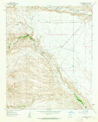
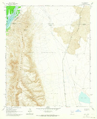
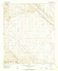 1961 Priest Tank1963 Print · USGSSierra County ranch lands and irrigation networks are captured here in the early sixties, centered on the community of Placitas. Researchers can trace communal water systems like the Monticello Community Ditch or locate family landmarks such as Lopez Windmill and Samora Tank.2 unique versions available
 - 1961 Map of Huerfano Hill, 1963 Print
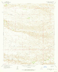
 1961 Huerfano Hill1963 Print · USGSSierra County ranch lands and river canyons are captured here in the early sixties, showing a landscape defined by water rights and remote access. Trace family ranching history through landmarks like Samora, the Cuchillo Community Allotment Res, and Huerfano Tank.3 unique versions available
 - 1961 Map of Sierra Fijardo, 1963 Print
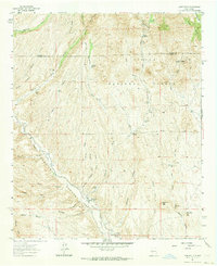
 1961 Sierra Fijardo1963 Print · USGSCentral New Mexico's high desert landscape comes into focus in the early sixties, showing the ranching and livestock culture of the era. Genealogists and historians can locate a Grave near Peñasco Canyon or trace the boundaries of the Flying X Ranch.2 unique versions available
 - 1961 Map of Skute Stone Arroyo, 1963 Print
 1961 Skute Stone Arroyo1963 Print · USGSSierra County ranching and mining operations are captured here in the early sixties, showing a landscape defined by deep arroyos and remote outposts. Researchers can trace land use at Coalson Ranch or locate the early workings at the Strip Mines.
 - 1961 Map of Saladone Tank, 1963 Print
 1961 Saladone Tank1963 Print · USGSSierra County ranch lands are shown in the early sixties, highlighting a landscape where water management was essential for survival. Researchers can trace remote ranching infrastructure like Saladone Tank, Las Animas Spr, and the Ladder Ranch Landing Strip.2 unique versions available
 - 1961 Map of Black Bluffs, 1963 Print
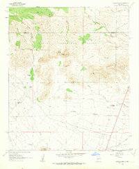
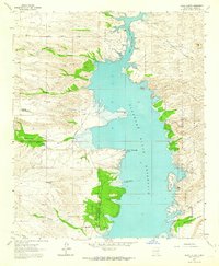 1961 Black Bluffs1963 Print · USGSSierra County in the early sixties reveals a landscape shaped by the Elephant Butte Reservoir and historic land grants. Genealogists and historians can trace the Pedro Armendaris No 33 Grant Boundary or locate Elkins Ranch and Monticello near the Alamosa River.4 unique versions available
 - 1961 Map of Crocker, 1963 Print
 1961 Crocker1963 Print · USGSSierra County's arid ranchlands and mountain passes are captured here in the early sixties, as the railroad era still defined local transport. Genealogists can trace family landmarks and remote outposts like Deep Well Ranch, Crocker, and the historic Massacre Gap.2 unique versions available
 - 1961 Map of Caballo, 1964 Print
 1961 Caballo1964 Print · USGSThe Sierra County shoreline in the early sixties centers on the management of the Rio Grande. Genealogists and historians can locate the Cem near Las Animas Creek, trace the Jesp Trail, or identify structures at Oasis and Caballo.3 unique versions available
 - 1961 Map of Nutt, 1964 Print
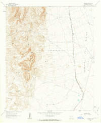
 1961 Nutt1964 Print · USGSThe high desert at the meeting of Sierra, Dona Ana, and Luna counties is captured here in the early sixties as the rail-and-ranch economy shaped the landscape. Trace family history at North Cem or Duncan Ranch, and follow the old Atchison Topeka and Santa Fe line past Nutt.2 unique versions available
 - 1961 Map of Williamsburg NW, 1964 Print
 1961 Williamsburg NW1964 Print · USGSSierra County’s arid canyon lands are captured here in the early sixties, showing the vital irrigation networks that sustained life. Trace the path of the Cuchillo Community Ditch or locate the San Miguel Ch and Garcia Place.2 unique versions available
 - 1961 Map of Clark Spring Canyon, 1964 Print
 1961 Clark Spring Canyon1964 Print · USGSSierra County ranching lands are captured here in the early sixties, showing a landscape defined by water scarcity and remote outposts. Researchers can trace historic water rights and land use through Apedaca Windmill, Berrenda Well, and Clark Spring.2 unique versions available
 - 1961 Map of Williamsburg, 1964 Print
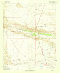
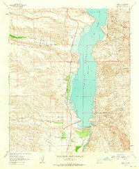
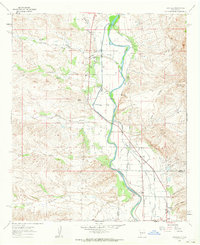
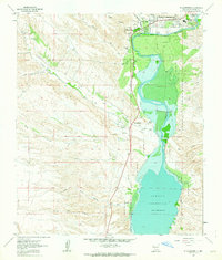 1961 Williamsburg1964 Print · USGSSierra County's river valley comes into focus in the early sixties, showing the vital connection between the desert settlements and the water. Researchers can trace the development of Williamsburg and Las Palomas alongside features like the Rodeo Ground and the Caballo Reservoir.3 unique versions available
 - 1961 Map of Monticello, 1964 Print
 1961 Monticello1964 Print · USGSSierra County ranching and river life are captured here in the early 1960s, centered on the Alamosa River valley. Genealogists and local historians can trace family ties at the Monticello Cem, St Ignatius Ch, and the outlying settlement of Placitas.2 unique versions available
 - 1961 Map of Lava, 1964 Print
 1961 Lava1964 Print · USGSSierra County's high desert is captured here in the early sixties, as the high peaks of the Fra Cristobal Range overlook the Rio Grande. Researchers can trace the Atchison Topeka and Santa Fe railroad through the Jornada del Muerto to the Lava Well Ranch.3 unique versions available
 - 1961 Map of Garfield, 1964 Print
 1961 Garfield1964 Print · USGSThe Rio Grande valley in southern New Mexico during the early sixties reveals a landscape shaped by massive irrigation projects. Researchers can trace family homesteads and local infrastructure through labels like San Isidro Sch, Percha Dam, and John Trujillo Windmill.2 unique versions available
 - 1961 Map of Cuchillo, 1964 Print
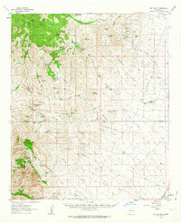
 1961 Cuchillo1964 Print · USGSSierra County ranching and town life are documented here in the early sixties, centered on the Mud Springs Mountains. Researchers can trace old family ranching history through Pendergrass Tank, Doolittle Tank No 1, and the settlement at Cuchillo.
 - 1961 Map of Romero Canyon, 1964 Print
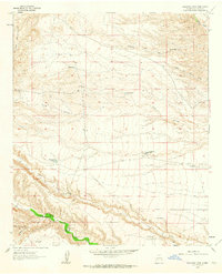
 1961 Romero Canyon1964 Print · USGSThe Sierra County desert meets the rising waters of the Elephant Butte Reservoir in the early sixties. Genealogists and researchers can trace local ranching landmarks like Old Pankey Ranch and remote infrastructure such as Pete Well Road.3 unique versions available
 - 1962 Map of Clifton
 1962 Clifton1962 Print · USGSThe copper-rich Arizona-New Mexico borderlands come into focus in the early sixties, centered on the mining complexes of Morenci and Clifton. Researchers can trace the Southern Pacific rail lines and locate remote outposts like Honeymoon and the Double Circle Ranch.
 - 1962 Map of Lake Valley, 1964 Print
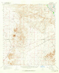
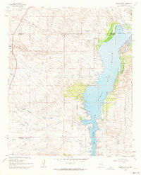
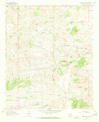
 1962 Lake Valley1964 Print · USGSSierra County's mining and ranching history comes alive in this early 1960s survey of the high-desert country. Trace the Old Railroad Grade leading to the famous Bridal Chamber Mine and locate family outposts like the Rooth Ranch and DeMuth Ranch.2 unique versions available
 - 1963 Map of Bonner Canyon, 1965 Print
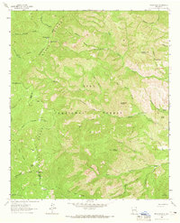
 1963 Bonner Canyon1965 Print · USGSThe Continental Divide cuts through the Gila National Forest in the early sixties, illustrating a landscape defined by high peaks and ranching heritage. Researchers can trace water sources and named landmarks like Me Own Tank, Alligator Tank, and the Rastus Flats plateau.2 unique versions available
 - 1963 Map of Bell Mountain, 1965 Print
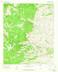
 1963 Bell Mountain1965 Print · USGSSierra County ranching and rugged topography are frozen in time during the early sixties. Researchers can trace remote desert homesteads and vital water infrastructure through landmarks like Francisco Rascon Place, Ladders Ranch, and Higgins Well.
 - 1963 Map of Thumb Tank Peak, 1965 Print
 1963 Thumb Tank Peak1965 Print · USGSThe Sierra County high country in the 1960s was a landscape defined by ranching life and seasonal water. Genealogists and historians can trace family-named sites and remote outposts like Evans Ranch, Avilas Camp, and Lobo Tank.2 unique versions available
 - 1963 Map of Reeds Peak, 1965 Print
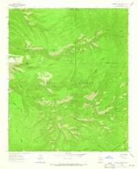
 1963 Reeds Peak1965 Print · USGSThe high backcountry of the Black Range comes into focus during the early sixties, showing the remote canyon lands of the Gila National Forest. Researchers can trace historic mountain activity through the locations of Reeds Ranch, the Whitmore Cabin, and the Lookout Tower atop Reeds Peak.2 unique versions available
 - 1963 Map of Sugarloaf Peak, 1965 Print
 1963 Sugarloaf Peak1965 Print · USGSSierra County mining and ranching are documented here during the early 1960s, centered on the historic settlement of Hermosa. Researchers can trace the legacy of local extraction at the Pelican Group Mines or locate family sites like Dines Rancho and the Hermosa Cem.
 - 1963 Map of Victoria Park, 1965 Print
 1963 Victoria Park1965 Print · USGSThe Black Range high country in the early sixties was a landscape of remote mountain outposts and critical water sources. Researchers can locate isolated landmarks like the McKnight Fire Cabin and historic clearings such as Kelso Place or Murphy Place.2 unique versions available
Showing maps 1-25 of 33
Top cities of Sierra County
Frequently asked questions
- What are the different types of historical maps available for Sierra County?
- What is the oldest map of Sierra County?
- Where can I purchase historical maps of Sierra County for my home or office?
- Where can I download high-res historical maps of Sierra County?
- Are there historical topographic maps available for Sierra County?
- Is there historical aerial imagery available for Sierra County?
- Where are historical maps of Sierra County sourced from?