Old Maps of Sierra County, New Mexico for Genealogy
Trace your family roots with 608 historic maps of Sierra County. These high-res maps reveal old neighborhoods, homesites, landmarks, and streets — helping you uncover where your ancestors lived and how the area evolved over time.
- Explore historic neighborhoods: Identify where your relatives may have lived in the 1800s or 1900s.
- Compare maps over time: Trace the changes in streets, buildings, and landmarks for multi-generational research.
- Perfect for genealogy & ancestry research: Used by family historians and researchers to map out lineage and migration.
These maps are an incredible resource for exploring your personal connection to Sierra County's past.
Sierra County, NM maps
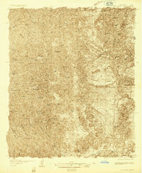
(608)- 1911 Map of Alum Mountain, 1959 Print
 1911 Alum Mountain1959 Print · USGSThe upper Gila River wilderness is documented here just after the turn of the century, showing a landscape of remote cattle ranches and early mining claims. Genealogists and researchers can trace family-named sites like TJ Ranch and the Meerschaum Mine, or locate the Gila Cliff-Dwellings National Monument.
 - 1913 Map of Alum Mountain
 1913 Alum Mountain1913 Print · USGSNew Mexico's high wilderness is captured here just after statehood, documenting the remote ranching outposts and ancient sites along the Gila River. Researchers can locate early twentieth-century landmarks like Gila Cliff Dwellings National Monument, the Meerschaum Mine, and the XSX Ranch.3 unique versions available
 - 1916 Map of Tonuco
 1916 Tonuco1916 Print · USGSDona Ana and Socorro counties are shown during the mid-1910s, capturing a landscape of isolated desert ranches and railroad stops. Genealogists can trace family outposts and water sources such as Flat Lake Ranch, Baird's Ranch, and Red Lake well.
 - 1916 Map of Salinas Peak
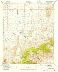
 1916 Salinas Peak1916 Print · USGSSouthern New Mexico was a land of expansive ranches and rail stops in the years before the Great War. You can trace early twentieth-century desert survival through water landmarks like Anaya Spring and rail-side settlements including Engle and Cutter.
 - 1916 Map of Tularosa
 1916 Tularosa1916 Print · USGSNew Mexico ranching and railroading define this pre-war survey of the valley during its early years of statehood. Genealogists and historians can trace family landholdings at Jackson Ranch and Chosa Ranch or follow the path of the El Paso and Southwestern railroad.2 unique versions available
 - 1916 Map of Point Of Sands
 1916 Point Of Sands1916 Print · USGSThe Tularosa Basin in the years before the Great War was a world of remote cattle ranches and alkali plains. Researchers can trace the heritage of the Tularosa frontier through family landmarks like Pelman Ranch, Bairds Wells, and the Eddy Soda Prospect.2 unique versions available
 - 1932 Map of Tonuco
 1932 Tonuco1932 Print · USGSThe high desert of southern New Mexico appears here as a land of isolated ranches and railroad sidings in the early 1930s. Genealogists and historians can trace family-named outposts like Detroit Ranch and Ritch Ranch or follow the A. T. & S. F. line past Aleman.
 - 1935 Map of Hillsboro
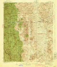
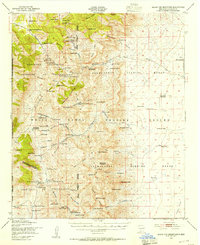
 1935 Hillsboro1935 Print · USGSHillsboro and Kingston are documented here in the mid-1930s, surrounded by the busy mining and ranching country of the Black Range. Genealogists and historians can locate family landmarks like the J P Nunn Ranch and Wilson Ranch or trace the footprint of the Silver Tail Mine.2 unique versions available
 - 1940 Map of Hillsboro
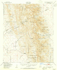
 1940 Hillsboro1940 Print · USGSSierra County mountain life in the mid-1930s centers on mining outposts and remote cattle ranches within the Black Range. Genealogists and historians can trace family operations at the JP Nunn Ranch and Wilson Ranch or locate the historic Gray Eagle Mine near Kingston.2 unique versions available
 - 1947 Map of Point Of Sands 2, 1954 Print
 1947 Point Of Sands 21954 Print · USGSThe Tularosa Basin in the late 1940s reveals a transition from ranching lands to a high-tech military testing range. Researchers can locate remote sites like Andrecito alongside early aerospace landmarks like Landing Strip No 1 and Lake Lucero.
 - 1947 Map of Capitol Peak, 1955 Print
 1947 Capitol Peak1955 Print · USGSThe northern reaches of the San Andres Mountains appear at the dawn of the atomic age, as the White Sands Proving Ground was being established. Researchers can trace remote water sources like Malpais Spring and the complex terrain of the Lava Bed and Mockingbird Gap.
 - 1948 Map of Sowell
 1948 Sowell1948 Print · USGSSierra and Socorro counties at the end of the 1940s reveal a landscape shaped by vast land grants and high-desert ranching. Researchers can trace the layout of remote outposts like Sowell Ranch Headquarters and water systems like Adobe House Tank or Sevenmile Tank.3 unique versions available
 - 1948 Map of Chicken Well, 1954 Print
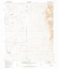
 1948 Chicken Well1954 Print · USGSCattle ranching in the late 1940s relied on an intricate web of artificial tanks and deep wells across this desert landscape. Researchers can locate family operations like Aleman Ranch Headquarters and trace vital water sources including Chicken Well and Point of Rocks.
 - 1948 Map of Malpais Well, 1954 Print
 1948 Malpais Well1954 Print · USGSThe high-desert ranching country of Socorro and Sierra counties is captured here just after the war. Researchers can trace the legacy of the Pedro Armendaris Grant No 33 and locate historic outposts like Casa Grande Ranch and Malpais Well.
 - 1948 Map of Kaylor Mountain, 1955 Print
 1948 Kaylor Mountain1955 Print · USGSDona Ana County was undergoing a major military and conservation transition just after the war. Researchers can trace the footprints of family holdings like the Fleck Ranch and Henderson Ranch alongside early sites for the White Sands Proving Ground.3 unique versions available
 - 1948 Map of Black Top Mountain, 1955 Print
 1948 Black Top Mountain1955 Print · USGSNew Mexico's high desert was a site of strategic transition in the late 1940s, balancing traditional ranching life with emerging military testing grounds. Researchers can find old homesteads like Hardin Ranch and family sites such as Woolf Ranch Headquarters alongside the Black Bear Mine.3 unique versions available
 - 1948 Map of Salinas Peak, 1955 Print
 1948 Salinas Peak1955 Print · USGSThe high desert of Socorro and Sierra Counties is shown here in the late forties, just as military testing grounds began to redefine the landscape. Genealogists and researchers can trace ranching footprints like Cain Ranch Headquarters and Martin Headquarters or locate the Bear Den Sch.2 unique versions available
 - 1948 Map of Lumley Lake, 1956 Print
 1948 Lumley Lake1956 Print · USGSPost-war New Mexico comes into focus as the desert is transformed for military testing. Trace early Cold War history through Alamogordo Bombing Range, Landing Field No 2, and local sites like MacDonald Camp.
 - 1949 Map of Lookout Mountain, 1953 Print
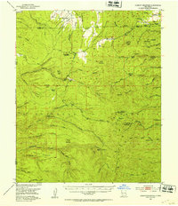 1949 Lookout Mountain1953 Print · USGSThe Gila National Forest during the late 1940s reveals a high-altitude landscape shaped by the Continental Divide and mining operations. Researchers can trace historic activity at the North Star Mine and family sites like Inman Ranch.3 unique versions available
 - 1954 Map of Tularosa, 1963 Print
 1954 Tularosa1963 Print · USGSSouth-central New Mexico in the early fifties shows a landscape of desert basins and high peaks under heavy military and water-reclamation use. Trace the path of the Atchison Topeka and Santa Fe Railway past San Marcial and into the massive White Sands Proving Ground.4 unique versions available
 - 1954 Map of Clifton, 1968 Print
 1954 Clifton1968 Print · USGSThe high timber and copper country of the Arizona-New Mexico border is captured here during the mid-fifties. Genealogists and historians can trace family holdings like the Double Circle Ranch or study the industrial footprint of the Smelting Plant at Clifton.3 unique versions available
 - 1955 Map of Las Cruces, 1963 Print
 1955 Las Cruces1963 Print · USGSSouthern New Mexico comes into focus during the mid-fifties, showing the growth of Las Cruces alongside major military and scientific installations. Genealogists and historians can trace the Southern Pacific tracks through small rail towns like Cambray and Afton, or locate family sites near Hatch and Deming.3 unique versions available
 - 1956 Map of San Lorenzo, 1959 Print
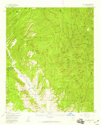 1956 San Lorenzo1959 Print · USGSThe Mimbres River valley and the high Black Range come together in this mid-century survey of Grant and Sierra counties. Researchers can trace the development of mining operations like the Royal John Mine and the Columbia Mine alongside the historic villages of San Lorenzo and San Juan.2 unique versions available
 - 1957 Map of Clifton
 1957 Clifton1957 Print · USGSThe copper-mining district around Clifton and Morenci meets the high timberlands of the Mogollon Rim during the mid-1950s. Genealogists and researchers can trace family-named outposts and remote mountain settlements like Reserve, Stargo, and Fort Thomas.
 - 1958 Map of Las Cruces
 1958 Las Cruces1958 Print · USGSSouthern New Mexico in the late fifties was a landscape of rapid scientific and military growth centered on the Rio Grande. Local historians can trace the development of Las Cruces, the campus of New Mexico A and M College, and remote rail sidings like Aden Siding.
Showing maps 1-25 of 608
Top cities of Sierra County
Frequently asked questions
- What are the different types of historical maps available for Sierra County?
- What is the oldest map of Sierra County?
- Where can I purchase historical maps of Sierra County for my home or office?
- Where can I download high-res historical maps of Sierra County?
- Are there historical topographic maps available for Sierra County?
- Is there historical aerial imagery available for Sierra County?
- Where are historical maps of Sierra County sourced from?