1930s Maps of Clinton County, New York
Explore 3 historic maps of Clinton County from the 1930s. These maps offer a rare glimpse into what life looked like during the 1930s — showing old roads, neighborhoods, homes, and landmarks that have changed or disappeared over time.
Whether you're researching your family's past, planning a metal detecting trip, or studying how Clinton County's landscape evolved across the 1930s, these high-resolution maps are a powerful tool for exploring the history of this region.
- Focus on a specific era: All maps on this page are from the 1930s, giving you a focused view of this time period.
- See what’s changed: Compare century-old streets, trails, and buildings to today's modern landscape using overlays and satellite layers.
- Research with precision: Use these maps for genealogy, historical research, land use analysis, or educational projects.
- View, download, or print: Maps are fully viewable online in high resolution, and can be downloaded or printed for your own records.
Start exploring Clinton County's history through authentic maps from the 1930s. This is your window into the past.
Clinton County, NY maps
(3)- 1931 Map of Lyon Mountain
 1931 Lyon Mountain1931 Print · USGSThe northern Adirondack mining and timber lands are shown here in the early 1900s, centered on the heights of Lyon Mountain. Researchers can trace the Chateaugay R.R. as it serves industrial sites like Junction Kilns and the settlement at Standish.
 - 1939 Map of Rouses Point
 1939 Rouses Point1939 Print · USGSThe northern reaches of Lake Champlain and the Canadian border come alive in this pre-war survey of the New York-Vermont frontier. Genealogists and historians can trace rail-and-water connections through Rouses Point, locate family landmarks like Doane Cem, and explore the grounds of Fort Montgomery.4 unique versions available
 - 1939 Map of Plattsburg
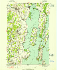
 1939 Plattsburg1939 Print · USGSLake Champlain was a vital corridor for rail and military activity just before the second World War. Genealogists and historians can trace the Plattsburg Barracks, the Rutland Railroad on Grand Isle, and landmarks like Hotel Champlain.
End of results
Showing maps 1-3 of 3
Top cities of Clinton County
- Plattsburgh historical maps
- Plattsburgh historical maps
- Peru historical maps
- Champlain historical maps
- Beekmantown historical maps
- Schuyler Falls historical maps
See more
Frequently asked questions
- What are the different types of historical maps available for Clinton County?
- What is the oldest map of Clinton County?
- Where can I purchase historical maps of Clinton County for my home or office?
- Where can I download high-res historical maps of Clinton County?
- Are there historical topographic maps available for Clinton County?
- Is there historical aerial imagery available for Clinton County?
- Where are historical maps of Clinton County sourced from?