1950s Maps of Clinton County, New York
Explore 11 historic maps of Clinton County from the 1950s. These maps offer a rare glimpse into what life looked like during the 1950s — showing old roads, neighborhoods, homes, and landmarks that have changed or disappeared over time.
Whether you're researching your family's past, planning a metal detecting trip, or studying how Clinton County's landscape evolved across the 1950s, these high-resolution maps are a powerful tool for exploring the history of this region.
- Focus on a specific era: All maps on this page are from the 1950s, giving you a focused view of this time period.
- See what’s changed: Compare century-old streets, trails, and buildings to today's modern landscape using overlays and satellite layers.
- Research with precision: Use these maps for genealogy, historical research, land use analysis, or educational projects.
- View, download, or print: Maps are fully viewable online in high resolution, and can be downloaded or printed for your own records.
Start exploring Clinton County's history through authentic maps from the 1950s. This is your window into the past.
Clinton County, NY maps
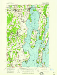
(11)- 1950 Map of Lake Champlain
 1950 Lake Champlain1950 Print · USGSThe Lake Champlain valley and its surrounding peaks are captured in detail during the late 1940s, showing the vital rail and road connections between New York and Vermont. Researchers can trace the routes of the Central Vermont Railway or locate old industrial centers like Mineville and Witherbee.2 unique versions available
 - 1951 Map of Ogdensburg
 1951 Ogdensburg1951 Print · USGSThe St. Lawrence frontier and the North Country are captured here during the post-war era, from the river ports to the high Adirondacks. Genealogists and historians can trace the rail-and-river economy through Ogdensburg, the Rutland rail lines, and Potsdam.
 - 1953 Map of Ogdensburg
 1953 Ogdensburg1953 Print · USGSThe North Country and St. Lawrence Valley are shown here in the early fifties, just as the region’s rail-and-river economy remained in full swing. Genealogists and historians can trace family-named corners and rural hubs along the Rutland railroad or locate heritage sites near Ogdensburg, Potsdam, and the St Regis Indian Reservation.
 - 1953 Map of Lake Placid, 1957 Print
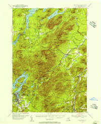 1953 Lake Placid1957 Print · USGSThe High Peaks region during the mid-fifties shows a landscape defined by mountain hamlets and early Adirondack tourism. Genealogists and historians can trace family sites at Quaker Cem, the John Browns Grave historic site, and early industrial landmarks like West Kilns.4 unique versions available
 - 1953 Map of Au Sable Forks, 1957 Print
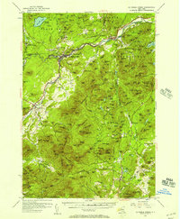 1953 Au Sable Forks1957 Print · USGSThe Adirondack foothills in the early fifties reveal a landscape where river industry meets mountain wilderness. Researchers can trace historic iron-working sites like Ore Mines and Soper Kiln, or locate family landmarks such as Stevens Landing and North Jay Cem.3 unique versions available
 - 1956 Map of Plattsburgh
 1956 Plattsburgh1956 Print · USGSLake Champlain and its island communities are captured here in the mid-fifties, just as the region's rail and water networks faced the rise of the jet age. Genealogists and historians can trace the foundations of Plattsburgh Air Force Base, old Vermont stations like Grand Isle Sta, and landmarks like Ausable Chasm.3 unique versions available
 - 1956 Map of Dannemora, 1957 Print
 1956 Dannemora1957 Print · USGSClinton County’s landscape in the mid-fifties centers on the institutional history of Dannemora and the timbered slopes of Terry Mountain. Genealogists and historians can trace numerous rural cemeteries like Quaker Cem and locate historic schools such as Beckwith Sch.3 unique versions available
 - 1956 Map of Rouses Point, 1958 Print
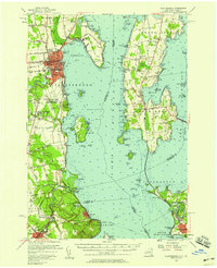
 1956 Rouses Point1958 Print · USGSLake Champlain's northern islands and shoreline are captured here in the mid-1950s, where the New York and Vermont borders meet Quebec. Researchers can locate family landmarks like the Miner Institute, St Marys Cem, and the ruins of Fort Montgomery.2 unique versions available
 - 1956 Map of Willsboro, 1958 Print
 1956 Willsboro1958 Print · USGSLake Champlain and the eastern Adirondacks come alive in the mid-1950s, showing the intricate shoreline from New York to Vermont. Genealogists can trace family roots through sites like Whallon Bay Sch, Boardman Cem, and the Lady of Hope Shrine.4 unique versions available
 - 1956 Map of Mooers, 1958 Print
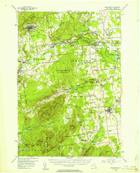
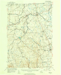 1956 Mooers1958 Print · USGSClinton County's borderlands are captured here in the mid-1950s, showing a landscape defined by international crossings and historic rail lines. Researchers can trace family roots through sites like Union Cemetery or follow the early industrial sites at Woods Falls and Purdy Mill.3 unique versions available
 - 1958 Map of Lake Champlain
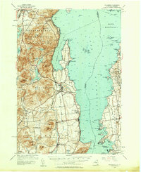
 1958 Lake Champlain1958 Print · USGSThe Champlain Valley and surrounding high peaks are captured here in the late fifties, showcasing the cross-border region from the Adirondacks to the Green Mountains. Researchers can trace historic rail routes like the Rutland Railway or locate old valley settlements such as Keeseville and Vergennes.2 unique versions available
End of results
Showing maps 1-11 of 11
Top cities of Clinton County
- Plattsburgh historical maps
- Plattsburgh historical maps
- Peru historical maps
- Champlain historical maps
- Beekmantown historical maps
- Schuyler Falls historical maps
See more
Frequently asked questions
- What are the different types of historical maps available for Clinton County?
- What is the oldest map of Clinton County?
- Where can I purchase historical maps of Clinton County for my home or office?
- Where can I download high-res historical maps of Clinton County?
- Are there historical topographic maps available for Clinton County?
- Is there historical aerial imagery available for Clinton County?
- Where are historical maps of Clinton County sourced from?