1940s Maps of Clinton County, New York
Explore 10 historic maps of Clinton County from the 1940s. These maps offer a rare glimpse into what life looked like during the 1940s — showing old roads, neighborhoods, homes, and landmarks that have changed or disappeared over time.
Whether you're researching your family's past, planning a metal detecting trip, or studying how Clinton County's landscape evolved across the 1940s, these high-resolution maps are a powerful tool for exploring the history of this region.
- Focus on a specific era: All maps on this page are from the 1940s, giving you a focused view of this time period.
- See what’s changed: Compare century-old streets, trails, and buildings to today's modern landscape using overlays and satellite layers.
- Research with precision: Use these maps for genealogy, historical research, land use analysis, or educational projects.
- View, download, or print: Maps are fully viewable online in high resolution, and can be downloaded or printed for your own records.
Start exploring Clinton County's history through authentic maps from the 1940s. This is your window into the past.
Clinton County, NY maps
(10)- 1941 Map of Plattsburg
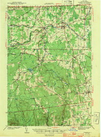
 1941 Plattsburg1941 Print · USGSLake Champlain was a critical corridor of military and transport activity in the years leading into the war. Researchers can trace the legacy of the Plattsburg Barracks, the winding Rutland rail line, and the geological site at Ausable Chasm.
 - 1941 Map of Willsboro
 1941 Willsboro1941 Print · USGSLake Champlain's shores in New York and Vermont are captured here just before the war, showing a landscape defined by lakefront landings and busy railroads. Trace the routes of the Delaware and Hudson and find local landmarks like Craterclub, Whallonsburg, and St Josephs Ch.2 unique versions available
 - 1942 Map of Mooers, 1956 Print
 1942 Mooers1956 Print · USGSClinton County's northern borderlands are captured here during the early 1940s, from the international line down to the slopes of the Adirondack foothills. Researchers can locate early district schoolhouses like Alder Bend Sch, tracing the rural rail connections of the RUTLAND and DELAWARE AND HUDSON lines.
 - 1943 Map of Churubusco
 1943 Churubusco1943 Print · USGSClinton County during the early war years remains a landscape of high summits and rural schoolhouses. Family historians can trace ancestral sites near Churubusco or locate properties along the Rutland line and the Great Chazy River.
 - 1943 Map of Mooers
 1943 Mooers1943 Print · USGSNorthern Clinton County at the height of the rail era shows a landscape of interconnected hamlets and river-powered industry along the Canadian border. Genealogists and local historians can trace family-named sites like Purdy Mill and Witherill Sch, or follow the path of the Rutland RR through Mooers and Altona.2 unique versions available
 - 1943 Map of Willsboro
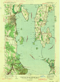
 1943 Willsboro1943 Print · USGSThe Lake Champlain shoreline in the early 1940s reveals a landscape of mountain-backed villages and vital cross-lake rail connections. Genealogists and researchers can trace local landmarks like St Josephs Ch, Lakeview Cem, and the path of the Delaware and Hudson railroad.3 unique versions available
 - 1943 Map of Rouses Point
 1943 Rouses Point1943 Print · USGSThe Lake Champlain borderlands in the early 1940s served as a critical international junction for rail and river transit between New York, Vermont, and Quebec. Researchers can trace historic family landmarks from Fort Montgomery to local schoolhouses like Rogers Sch and Barnes Sch.2 unique versions available
 - 1943 Map of Chateaugay
 1943 Chateaugay1943 Print · USGSFranklin County sits at the international border during the early years of the war, showing a landscape of small dairy farms and rail-dependent hamlets. Researchers can trace the path of the Rutland Railroad through Chateaugay and find local landmarks like Cooks Mill and Brainardsville.
 - 1943 Map of Plattsburg
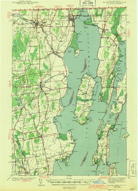
 1943 Plattsburg1943 Print · USGSLake Champlain was a bustling corridor of rail and water traffic in the early 1940s, connecting the Adirondack foothills to the Vermont islands. Genealogists and researchers can trace the old schoolhouses of Beekmantown, the Rutland railroad stops, and historic sites like Hotel Champlain.4 unique versions available
 - 1948 Map of Ogdensburg, 1973 Print
 1948 Ogdensburg1973 Print · USGSThe international border along the St Lawrence River comes to life in the late 1940s, showing the vital rail and water connections between New York and Ontario. Researchers can trace the grounds of St Lawrence University, the massive Camp Drum military reservation, and the historic Rideau River and Canal.2 unique versions available
End of results
Showing maps 1-10 of 10
Top cities of Clinton County
- Plattsburgh historical maps
- Plattsburgh historical maps
- Peru historical maps
- Champlain historical maps
- Beekmantown historical maps
- Schuyler Falls historical maps
See more
Frequently asked questions
- What are the different types of historical maps available for Clinton County?
- What is the oldest map of Clinton County?
- Where can I purchase historical maps of Clinton County for my home or office?
- Where can I download high-res historical maps of Clinton County?
- Are there historical topographic maps available for Clinton County?
- Is there historical aerial imagery available for Clinton County?
- Where are historical maps of Clinton County sourced from?