1940s Maps of Wales, New York
Explore 3 historic maps of Wales from the 1940s. These maps offer a rare glimpse into what life looked like during the 1940s — showing old roads, neighborhoods, homes, and landmarks that have changed or disappeared over time.
Whether you're researching your family's past, planning a metal detecting trip, or studying how Wales's landscape evolved across the 1940s, these high-resolution maps are a powerful tool for exploring the history of this region.
- Focus on a specific era: All maps on this page are from the 1940s, giving you a focused view of this time period.
- See what’s changed: Compare century-old streets, trails, and buildings to today's modern landscape using overlays and satellite layers.
- Research with precision: Use these maps for genealogy, historical research, land use analysis, or educational projects.
- View, download, or print: Maps are fully viewable online in high resolution, and can be downloaded or printed for your own records.
Start exploring Wales's history through authentic maps from the 1940s. This is your window into the past.
Wales, NY maps
(3)- 1948 Map of Depew, 1953 Print
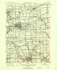 1948 Depew1953 Print · USGSErie County's industrial and civic heart comes into focus during this post-war era of rail and aviation expansion. Researchers can trace ancestral roots at Clarence Fillmore Cemetery or locate old schoolhouses like School No 1 and School No 8 across Harris Hill and Marilla.3 unique versions available
 - 1949 Map of Attica, 1953 Print
 1949 Attica1953 Print · USGSWestern New York at mid-century reveals a dense network of major railroads and rural hamlets across Genesee and Wyoming counties. Genealogists and historians can trace family locations through numerous numbered schools, named crossroads like Brick House Corners, and landmarks such as the Attica State Prison.
 - 1949 Map of Cowlesville, 1969 Print
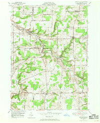 1949 Cowlesville1969 Print · USGSWyoming County's rural character is well-preserved here in the years following the war, showing a landscape defined by small crossroads hamlets and creek-side settlements. Genealogists can trace family roots through sites like Persons Corners, Persons Cem, and several numbered schoolhouses including School No 19.
End of results
Showing maps 1-3 of 3
Top cities near Wales
- Amherst historical maps
- Cheektowaga historical maps
- West Seneca historical maps
- Lancaster historical maps
- Clarence historical maps
- Orchard Park historical maps
See more
Top neighborhoods of Wales
Frequently asked questions
- What are the different types of historical maps available for Wales?
- What is the oldest map of Wales?
- Where can I purchase historical maps of Wales for my home or office?
- Where can I download high-res historical maps of Wales?
- Are there historical topographic maps available for Wales?
- Is there historical aerial imagery available for Wales?
- Where are historical maps of Wales sourced from?