1950s Maps of Wales, New York
Explore 4 historic maps of Wales from the 1950s. These maps offer a rare glimpse into what life looked like during the 1950s — showing old roads, neighborhoods, homes, and landmarks that have changed or disappeared over time.
Whether you're researching your family's past, planning a metal detecting trip, or studying how Wales's landscape evolved across the 1950s, these high-resolution maps are a powerful tool for exploring the history of this region.
- Focus on a specific era: All maps on this page are from the 1950s, giving you a focused view of this time period.
- See what’s changed: Compare century-old streets, trails, and buildings to today's modern landscape using overlays and satellite layers.
- Research with precision: Use these maps for genealogy, historical research, land use analysis, or educational projects.
- View, download, or print: Maps are fully viewable online in high resolution, and can be downloaded or printed for your own records.
Start exploring Wales's history through authentic maps from the 1950s. This is your window into the past.
Wales, NY maps
(4)- 1950 Map of East Aurora
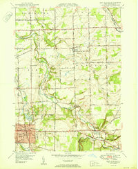 1950 East Aurora1950 Print · USGSMid-century Erie County comes alive in this survey of East Aurora and its surrounding townships during a period of steady post-war growth. Researchers can locate vanished landmarks like the local Tannery, numerous numbered district schools, and family burial grounds including Maplewood Cem and Evergreen Cem.
 - 1951 Map of Cowlesville
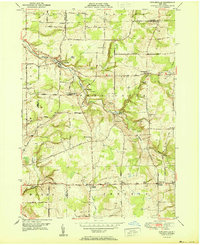 1951 Cowlesville1951 Print · USGSWestern New York's rural Wyoming County townships are shown here in the early fifties, a landscape of creek-fed valleys and small crossroads hamlets. Researchers can trace historic district schools and cemeteries like School No 12 and Fairview Cem near Cowlesville.
 - 1955 Map of Holland, 1957 Print
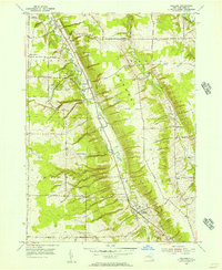 1955 Holland1957 Print · USGSErie County's southern valleys and highlands are caught mid-century, before modern development bypassed these rural hamlets. Genealogists can trace family names at Humphrey Cem and Hunter Creek Ch, or locate the old Gow Sch near South Wales.2 unique versions available
 - 1957 Map of Strykersville, 1958 Print
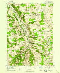 1957 Strykersville1958 Print · USGSWyoming and Erie County rural life is frozen here in the late fifties, as the valley of Buffalo Creek connects a network of crossroad hamlets and parish schools. Researchers can trace family sites near St Marys Cemetery, Plants Corners, and Dutch Hollow.2 unique versions available
End of results
Showing maps 1-4 of 4
Top cities near Wales
- Amherst historical maps
- Cheektowaga historical maps
- West Seneca historical maps
- Lancaster historical maps
- Clarence historical maps
- Orchard Park historical maps
See more
Top neighborhoods of Wales
Frequently asked questions
- What are the different types of historical maps available for Wales?
- What is the oldest map of Wales?
- Where can I purchase historical maps of Wales for my home or office?
- Where can I download high-res historical maps of Wales?
- Are there historical topographic maps available for Wales?
- Is there historical aerial imagery available for Wales?
- Where are historical maps of Wales sourced from?