1960s Maps of Waddington, New York
Explore 6 historic maps of Waddington from the 1960s. These maps offer a rare glimpse into what life looked like during the 1960s — showing old roads, neighborhoods, homes, and landmarks that have changed or disappeared over time.
Whether you're researching your family's past, planning a metal detecting trip, or studying how Waddington's landscape evolved across the 1960s, these high-resolution maps are a powerful tool for exploring the history of this region.
- Focus on a specific era: All maps on this page are from the 1960s, giving you a focused view of this time period.
- See what’s changed: Compare century-old streets, trails, and buildings to today's modern landscape using overlays and satellite layers.
- Research with precision: Use these maps for genealogy, historical research, land use analysis, or educational projects.
- View, download, or print: Maps are fully viewable online in high resolution, and can be downloaded or printed for your own records.
Start exploring Waddington's history through authentic maps from the 1960s. This is your window into the past.
Waddington, NY maps
(6)- 1961 Map of Ogdensburg
 1961 Ogdensburg1961 Print · USGSThe St. Lawrence valley and the Adirondack high country meet in this early sixties survey during a peak era for rail and river commerce. Genealogists and historians can trace the paths of the New York Central railroad through remote settlements like Wanakena, Conifer, and Piercefield.
 - 1963 Map of Sparrowhawk Point, 1965 Print
 1963 Sparrowhawk Point1965 Print · USGSThe international border along the St. Lawrence River is captured here in the early sixties as modern seaway engineering met old riverfront townships. Genealogists can locate family burial sites at Union Cem and O'Neill Cem or trace the rural routes of Bull Run Road and Keystone Road.2 unique versions available
 - 1964 Map of Louisville, 1966 Print
 1964 Louisville1966 Print · USGSSt. Lawrence County and the Ontario border meet here in the mid-sixties, following the transformation of the river by the seaway project. Researchers can trace local heritage at Upper Canada Village, Louisville, and several Community Cems.
 - 1964 Map of Chase Mills, 1966 Print
 1964 Chase Mills1966 Print · USGSSt. Lawrence County is captured here in the mid-1960s, showing a network of rural hamlets and river-driven landscapes before modern redevelopment. Researchers can locate family burial plots at Haskell Ridge Cem and trace the paths between old crossroads like Dalton Crossing and Chase Mills.
 - 1964 Map of Waddington, 1966 Print
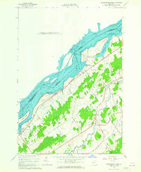
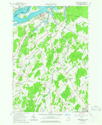 1964 Waddington1966 Print · USGSThe St. Lawrence River frontier and the rural hinterland of Waddington appear here in the mid-sixties, following the completion of the Seaway. Genealogists can trace family footprints across numerous named intersections like Drews Corner, Chipman, and Cogswell Corners.2 unique versions available
 - 1964 Map of Morrisburg, 1975 Print
 1964 Morrisburg1975 Print · USGSThe northern banks of the St. Lawrence River come alive in the mid-1960s, showing the settled landscape of Ontario and New York. Genealogists and local historians can trace the riverside communities of Morrisburg, Mariatown, and Riverside Heights alongside the prominent Ogden Island.
End of results
Showing maps 1-6 of 6
Top cities near Waddington
- Potsdam historical maps
- Canton historical maps
- Potsdam historical maps
- Canton historical maps
- Norfolk historical maps
- Lisbon historical maps
See more
Top neighborhoods of Waddington
- Drews Corner historical maps
- Dalton Crossing historical maps
- Chipman historical maps
- Waddington historical maps
Frequently asked questions
- What are the different types of historical maps available for Waddington?
- What is the oldest map of Waddington?
- Where can I purchase historical maps of Waddington for my home or office?
- Where can I download high-res historical maps of Waddington?
- Are there historical topographic maps available for Waddington?
- Is there historical aerial imagery available for Waddington?
- Where are historical maps of Waddington sourced from?