1950s Maps of Washington County, New York
Explore 18 historic maps of Washington County from the 1950s. These maps offer a rare glimpse into what life looked like during the 1950s — showing old roads, neighborhoods, homes, and landmarks that have changed or disappeared over time.
Whether you're researching your family's past, planning a metal detecting trip, or studying how Washington County's landscape evolved across the 1950s, these high-resolution maps are a powerful tool for exploring the history of this region.
- Focus on a specific era: All maps on this page are from the 1950s, giving you a focused view of this time period.
- See what’s changed: Compare century-old streets, trails, and buildings to today's modern landscape using overlays and satellite layers.
- Research with precision: Use these maps for genealogy, historical research, land use analysis, or educational projects.
- View, download, or print: Maps are fully viewable online in high resolution, and can be downloaded or printed for your own records.
Start exploring Washington County's history through authentic maps from the 1950s. This is your window into the past.
Washington County, NY maps
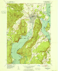
(18)- 1950 Map of Glens Falls
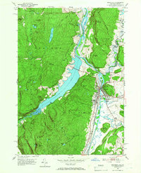
 1950 Glens Falls1950 Print · USGSThe Adirondacks and the Green Mountains meet in this mid-century survey of the New York and Vermont borderlands. Researchers can trace the industrial rail corridors of the Rutland RR and Delaware & Hudson RR connecting Glens Falls, Rutland, and the shores of Lake George.
 - 1950 Map of Salem, 1951 Print
 1950 Salem1951 Print · USGSMid-century Washington County reveals a landscape of valley farms and mountain ridges just as the post-war era began. Genealogists and local historians can trace the tracks of the Delaware and Hudson railroad or locate family plots in Evergreen Cem and Cleveland Cem.
 - 1950 Map of Eagle Bridge, 1951 Print
 1950 Eagle Bridge1951 Print · USGSPost-war Upstate New York comes to life along the Hoosic River valley at the Washington and Rensselaer county line. Trace family roots through rural hamlets like Eagle Bridge, Buskirk, and West Hoosick, or locate old landmarks like School No 4 and Woodside Cem.
 - 1950 Map of Ticonderoga, 1952 Print
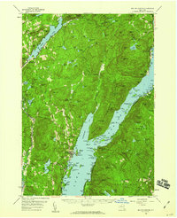
 1950 Ticonderoga1952 Print · USGSThe Ticonderoga region was a vital crossroads at mid-century, where the waters of Lake George and Lake Champlain meet. Genealogists and historians can trace the foundations of the area through landmarks like Fort Ticonderoga, St Marys Cem, and the old Lower Chilson Sch.9 unique versions available
 - 1950 Map of Putnam, 1952 Print
 1950 Putnam1952 Print · USGSNew York’s Adirondack foothills meet the Vermont border at mid-century, spanning the high ground between two major lakes. Genealogists and historians can trace the lakeside settlements of Putnam and Dresden or find old family sites like Gilletts Cem and the Swale Sch.5 unique versions available
 - 1950 Map of Ticonderoga, 1960 Print
 1950 Ticonderoga1960 Print · USGSThe Champlain Valley around the Vermont and New York border comes into focus just after the war, showing a landscape defined by its historic forts and rail lines. Genealogists and historians can trace family-named landmarks like Burdick Crossing, local schools such as Lake Sch, and old cemeteries including Lakeview Cem.3 unique versions available
 - 1950 Map of Whitehall, 1960 Print
 1950 Whitehall1960 Print · USGSMid-century Washington County and the Vermont border are revealed here at a time when the lake-and-rail economy remained central. Genealogists and historians can trace family plots at Dresden Cem, locate the William Miller Chapel, or find the old Hooper Mine and Carver Falls Dam.2 unique versions available
 - 1950 Map of Whitehall, 1966 Print
 1950 Whitehall1966 Print · USGSWhitehall and the New York-Vermont border appear at a post-war industrial peak where the railroad meets the Mettawee River. Trace family roots at Our Lady of Angels Cem or locate the rural Death Rock Sch and Pike Brook Sch.4 unique versions available
 - 1951 Map of Cossayuna
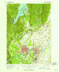
 1951 Cossayuna1951 Print · USGSWashington County in the early fifties is mapped here as a land of lakeside hamlets and upland ridges. Genealogists and historians can locate legacy sites like the County Farm, the Argyle Cem, and rural schoolhouses including Rock Hill Sch.
 - 1954 Map of Schaghticoke, 1956 Print
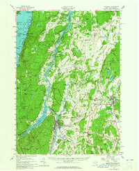
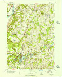 1954 Schaghticoke1956 Print · USGSIn the mid-1950s, the Hoosic River valley hummed with industry and agriculture as rail lines connected thriving villages. Genealogists and historians can trace family ties at the Little Red Schoolhouse, St Johns Ch, and Elmwood Cemetery.4 unique versions available
 - 1954 Map of Mechanicville, 1956 Print
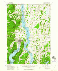
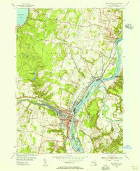 1954 Mechanicville1956 Print · USGSMechanicville and the Upper Hudson Valley thrive as a hub of rail and water transport during the mid-fifties. Researchers can trace the path of the Champlain Canal, explore the grounds of Saratoga National Historical Park, and find family names in Hudson View Cem.4 unique versions available
 - 1955 Map of Glens Falls, 1958 Print
 1955 Glens Falls1958 Print · USGSThe Hudson River valley and the southern gateway to the Adirondacks are captured here in the mid-fifties. Genealogists and local historians can trace family plots at Union Cem, locate the Mud Street Sch, and explore the grounds of Fort William Henry.4 unique versions available
 - 1956 Map of Albany, 1968 Print
 1956 Albany1968 Print · USGSThe industrial heart of the Northeast is revealed in the mid-1950s, from the Hudson Valley to the Connecticut River. Researchers can trace the legacy of the Quabbin Reservoir, locate Westover Air Force Base, or follow the Rutland RR through the Green Mountains.2 unique versions available
 - 1956 Map of Glens Falls, 1968 Print
 1956 Glens Falls1968 Print · USGSUpper New York and the Vermont mountains are captured here in the mid-fifties, showing the rugged rail-and-river network of the Northeast. Researchers can trace the paths of the Delaware and Hudson RR and Rutland RR as they wind through valley towns like Poultney and Whitehall.3 unique versions available
 - 1957 Map of Albany
 1957 Albany1957 Print · USGSThe Tri-State region and Connecticut River Valley are captured here during a period of significant postwar growth and infrastructure expansion. Genealogists and historians can trace the rail-and-river economy through landmarks like the Boston and Maine railroad, Quabbin Reservoir, and Westover Air Force Base.
 - 1958 Map of Bolton Landing, 1960 Print
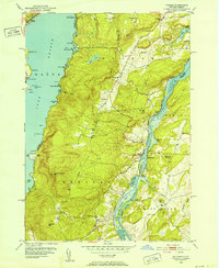
 1958 Bolton Landing1960 Print · USGSLake George and its rugged islands are the centerpiece of this mid-century survey of the eastern Adirondacks. Local historians and genealogists can trace property locations and landing sites from Bolton Landing to Hague, including features like Union Chapel and the historic Sabbathday Point.4 unique versions available
 - 1959 Map of Glens Falls
 1959 Glens Falls1959 Print · USGSUpper New York and Vermont are captured here during the late 1950s, a period of transition for these mountain communities. Researchers can trace the legacy of the region's river-and-rail economy through landmarks like Lake George, Saratoga Springs, and Killington Peak.2 unique versions available
 - 1959 Map of Albany
 1959 Albany1959 Print · USGSThe Hudson and Connecticut River valleys are captured here during the late fifties, showing the region's dense rail networks and massive water projects. Researchers can trace the New York State Thruway or locate local landmarks like Mt Greylock and the Quabbin Reservoir.
End of results
Showing maps 1-18 of 18
Top cities of Washington County
- Kingsbury historical maps
- Granville historical maps
- Fort Edward historical maps
- Fort Ann historical maps
- Greenwich historical maps
- Whitehall historical maps
See more
Frequently asked questions
- What are the different types of historical maps available for Washington County?
- What is the oldest map of Washington County?
- Where can I purchase historical maps of Washington County for my home or office?
- Where can I download high-res historical maps of Washington County?
- Are there historical topographic maps available for Washington County?
- Is there historical aerial imagery available for Washington County?
- Where are historical maps of Washington County sourced from?