1960s Maps of Washington County, New York
Explore 12 historic maps of Washington County from the 1960s. These maps offer a rare glimpse into what life looked like during the 1960s — showing old roads, neighborhoods, homes, and landmarks that have changed or disappeared over time.
Whether you're researching your family's past, planning a metal detecting trip, or studying how Washington County's landscape evolved across the 1960s, these high-resolution maps are a powerful tool for exploring the history of this region.
- Focus on a specific era: All maps on this page are from the 1960s, giving you a focused view of this time period.
- See what’s changed: Compare century-old streets, trails, and buildings to today's modern landscape using overlays and satellite layers.
- Research with precision: Use these maps for genealogy, historical research, land use analysis, or educational projects.
- View, download, or print: Maps are fully viewable online in high resolution, and can be downloaded or printed for your own records.
Start exploring Washington County's history through authentic maps from the 1960s. This is your window into the past.
Washington County, NY maps
(12)- 1962 Map of Albany
 1962 Albany1962 Print · USGSThe Hudson and Connecticut River valleys meet the Green Mountains and Berkshires in this mid-century overview of the Northeast. Genealogists and historians can trace the industrial hearts of Albany and Springfield or locate features like Quabbin Reservoir and Westover Air Force Base.
 - 1964 Map of Glens Falls
 1964 Glens Falls1964 Print · USGSThe tri-state borderlands of New York, Vermont, and New Hampshire appear here in the mid-1960s. Researchers can trace the rail routes of the Rutland RR and find historic sites like Ticonderoga and Saratoga National Historical Park.
 - 1964 Map of Poultney, 1965 Print
 1964 Poultney1965 Print · USGSRutland County in the mid-1960s shows a landscape shaped by the slate industry and deep-rooted collegiate towns. Researchers can trace historic family cemeteries like Ward Cem and Gates Cem or follow the path of the Delaware and Hudson railroad.4 unique versions available
 - 1966 Map of Hudson Falls, 1968 Print
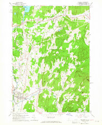
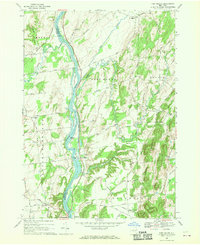
 1966 Hudson Falls1968 Print · USGSThe industrial riverfronts of Washington County are seen here in the mid-sixties as they grew around the historic locks and falls. Researchers can trace the path of the Champlain Canal, locate family plots in Union Cemetery, and see the early footprint of Adirondack Community College.3 unique versions available
 - 1966 Map of Lake George, 1969 Print
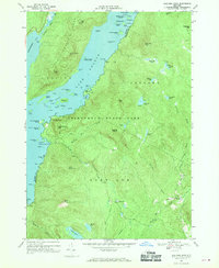
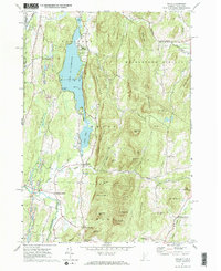
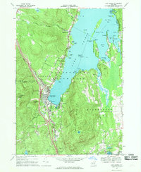 1966 Lake George1969 Print · USGSLake George enters a new era of accessibility in the mid-sixties as the Adirondack Northway connects with established mountain resorts. Researchers can trace historic sites like Fort William Henry alongside local landmarks such as the Stone Schoolhouse and Bloody Pond.3 unique versions available
 - 1966 Map of Bolton Landing, 1969 Print
 1966 Bolton Landing1969 Print · USGSLake George's western shoreline in the mid-sixties is captured here, showing the village of Bolton Landing as it balanced mountain heritage with lakeside development. Genealogists and historians can trace family sites at New Vermont Cem and Lamb Hill Cem or locate old crossings along the Schroon River.2 unique versions available
 - 1966 Map of Putnam Mountain, 1970 Print
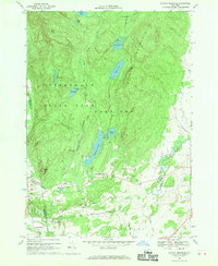 1966 Putnam Mountain1970 Print · USGSIn the mid-1960s, the Washington County uplands were a mix of deep Adirondack wilderness and small rural crossroads. Genealogists and hikers can trace the family history of West Fort Ann near Orcutt Cem or locate the old Iron Furnace near Mount Hope.2 unique versions available
 - 1966 Map of Shelving Rock, 1970 Print
 1966 Shelving Rock1970 Print · USGSLake George and the eastern Adirondacks are shown in detail during the mid-1960s, capturing the area's transition from lakeside settlements to high mountain wilderness. Trace the landings at Pilot Knob, explore the islands of Northwest Bay, or locate old interior sites like Hogtown.3 unique versions available
 - 1966 Map of Silver Bay, 1970 Print
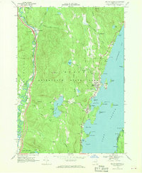
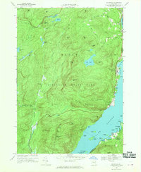 1966 Silver Bay1970 Print · USGSLake George shorelines and the high Adirondack interior meet in the mid-1960s, showing a landscape of remote mountain ponds and lakeside landings. Trace family history at the Wardsboro Cem or explore the historic docks at Silver Bay and Huletts Landing.2 unique versions available
 - 1967 Map of Schuylerville, 1970 Print
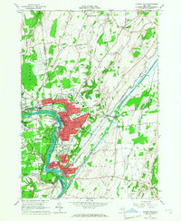
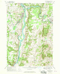 1967 Schuylerville1970 Print · USGSThe Hudson River valley and the industrial corridor of the Batten Kill are captured here in the late sixties. Genealogists and local historians can trace family-named routes like Hanehan Rd and landmarks including Victory Mills and Starks Knob.
 - 1967 Map of Ft Miller, 1970 Print
 1967 Ft Miller1970 Print · USGSThe Hudson River valley north of Schuylerville comes into focus in the late 1960s, showing a landscape shaped by river transport and upland farming. Researchers can trace the path of the Champlain Canal or locate family homesteads along Gavettes Road and Hunter Road.2 unique versions available
 - 1967 Map of Wells, 1972 Print
 1967 Wells1972 Print · USGSThe Vermont-New York borderlands near Wells were characterized by a mix of summer recreation and mountain industry in the 1960s. Researchers can trace the slate-country heritage through various Quarries or locate family sites at Barden Cem and Blossom Corners.2 unique versions available
End of results
Showing maps 1-12 of 12
Top cities of Washington County
- Kingsbury historical maps
- Granville historical maps
- Fort Edward historical maps
- Fort Ann historical maps
- Greenwich historical maps
- Whitehall historical maps
See more
Frequently asked questions
- What are the different types of historical maps available for Washington County?
- What is the oldest map of Washington County?
- Where can I purchase historical maps of Washington County for my home or office?
- Where can I download high-res historical maps of Washington County?
- Are there historical topographic maps available for Washington County?
- Is there historical aerial imagery available for Washington County?
- Where are historical maps of Washington County sourced from?