1990s Maps of Washington County, New York
Explore 4 historic maps of Washington County from the 1990s. These maps offer a rare glimpse into what life looked like during the 1990s — showing old roads, neighborhoods, homes, and landmarks that have changed or disappeared over time.
Whether you're researching your family's past, planning a metal detecting trip, or studying how Washington County's landscape evolved across the 1990s, these high-resolution maps are a powerful tool for exploring the history of this region.
- Focus on a specific era: All maps on this page are from the 1990s, giving you a focused view of this time period.
- See what’s changed: Compare century-old streets, trails, and buildings to today's modern landscape using overlays and satellite layers.
- Research with precision: Use these maps for genealogy, historical research, land use analysis, or educational projects.
- View, download, or print: Maps are fully viewable online in high resolution, and can be downloaded or printed for your own records.
Start exploring Washington County's history through authentic maps from the 1990s. This is your window into the past.
Washington County, NY maps
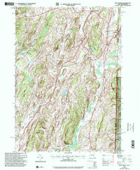
(4)- 1995 Map of Shushan, 2000 Print
 1995 Shushan2000 Print · USGSWashington County, New York, and the Vermont borderland are captured here in the mid-1990s, showcasing a network of historic rural settlements. Genealogists and researchers can trace family lands near Shushan, Pumpkin Hook, and the Bininger Cem, or locate the district schoolhouses that once served these valley communities.
 - 1995 Map of Salem, 2000 Print
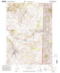
 1995 Salem2000 Print · USGSThe rural landscape of the New York-Vermont border is captured here during the mid-1990s, centering on the valley of the Batten Kill. Researchers can trace old family names and settlements through landmarks like Evergreen Cem, Rexleigh, and the rail junction at Greenwich Junc.
 - 1995 Map of West Pawlet, 2000 Print
 1995 West Pawlet2000 Print · USGSCrossing the New York and Vermont border in the mid-1990s, this area shows a landscape of upland ridges and clustered valley hamlets. Researchers can trace rural lineages through numerous sites like Taylor Hill Cem or locate the site of Chamberlain Mills along the creek beds.2 unique versions available
 - 1995 Map of Hoosick Falls, 2000 Print
 1995 Hoosick Falls2000 Print · USGSThe Rensselaer County borderlands come alive in the mid-nineties as small settlements and rail junctions follow the winding river valleys into Vermont. Researchers can trace family sites from St Marys Ch to rural outposts like Post Corners and Center White Creek.
End of results
Showing maps 1-4 of 4
Top cities of Washington County
- Kingsbury historical maps
- Granville historical maps
- Fort Edward historical maps
- Fort Ann historical maps
- Greenwich historical maps
- Whitehall historical maps
See more
Frequently asked questions
- What are the different types of historical maps available for Washington County?
- What is the oldest map of Washington County?
- Where can I purchase historical maps of Washington County for my home or office?
- Where can I download high-res historical maps of Washington County?
- Are there historical topographic maps available for Washington County?
- Is there historical aerial imagery available for Washington County?
- Where are historical maps of Washington County sourced from?