1970s Maps of Angier, North Carolina
Explore 3 historic maps of Angier from the 1970s. These maps offer a rare glimpse into what life looked like during the 1970s — showing old roads, neighborhoods, homes, and landmarks that have changed or disappeared over time.
Whether you're researching your family's past, planning a metal detecting trip, or studying how Angier's landscape evolved across the 1970s, these high-resolution maps are a powerful tool for exploring the history of this region.
- Focus on a specific era: All maps on this page are from the 1970s, giving you a focused view of this time period.
- See what’s changed: Compare century-old streets, trails, and buildings to today's modern landscape using overlays and satellite layers.
- Research with precision: Use these maps for genealogy, historical research, land use analysis, or educational projects.
- View, download, or print: Maps are fully viewable online in high resolution, and can be downloaded or printed for your own records.
Start exploring Angier's history through authentic maps from the 1970s. This is your window into the past.
Angier, NC maps
(3)- 1973 Map of Coats, 1975 Print
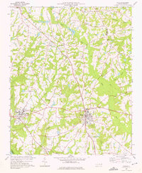 1973 Coats1975 Print · USGSHarnett County in the early seventies shows a landscape of small farming communities and academic growth centered around Campbell College. Genealogists and historians can trace the paths of the Durham and Southern line or locate rural landmarks like Barclaysville and Bethel Ch.3 unique versions available
 - 1974 Map of Fuquay-Varina, 1977 Print
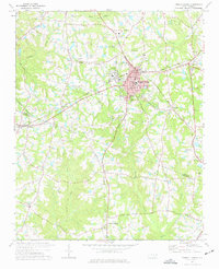 1974 Fuquay-Varina1977 Print · USGSThe intersection of the Durham and Norfolk Southern rail lines defines the Wake and Harnett county border in the mid-1970s. Local historians can trace the foundations of Fuquay-Varina and outlying communities like Chalybeate Springs, Wilbon, and Rawls.3 unique versions available
 - 1978 Map of Lillington
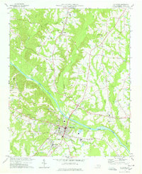 1978 Lillington1978 Print · USGSHarnett County during the late seventies centers on the river-and-rail corridor connecting Lillington to the rural north. Genealogists and local historians can trace legacy sites like Bethlehem Ch, Shawtown, and the Harnett Memorial Cem.2 unique versions available
End of results
Showing maps 1-3 of 3
Top cities near Angier
- Raleigh historical maps
- Cary historical maps
- Apex historical maps
- Fuquay-Varina historical maps
- Clayton historical maps
- Garner historical maps
See more
Top neighborhoods of Angier
Frequently asked questions
- What are the different types of historical maps available for Angier?
- What is the oldest map of Angier?
- Where can I purchase historical maps of Angier for my home or office?
- Where can I download high-res historical maps of Angier?
- Are there historical topographic maps available for Angier?
- Is there historical aerial imagery available for Angier?
- Where are historical maps of Angier sourced from?