1990s Maps of Robeson County, North Carolina
Explore 6 historic maps of Robeson County from the 1990s. These maps offer a rare glimpse into what life looked like during the 1990s — showing old roads, neighborhoods, homes, and landmarks that have changed or disappeared over time.
Whether you're researching your family's past, planning a metal detecting trip, or studying how Robeson County's landscape evolved across the 1990s, these high-resolution maps are a powerful tool for exploring the history of this region.
- Focus on a specific era: All maps on this page are from the 1990s, giving you a focused view of this time period.
- See what’s changed: Compare century-old streets, trails, and buildings to today's modern landscape using overlays and satellite layers.
- Research with precision: Use these maps for genealogy, historical research, land use analysis, or educational projects.
- View, download, or print: Maps are fully viewable online in high resolution, and can be downloaded or printed for your own records.
Start exploring Robeson County's history through authentic maps from the 1990s. This is your window into the past.
Robeson County, NC maps
(6)- 1990 Map of Whiteville
 1990 Whiteville1990 Print · USGSSoutheastern North Carolina and the South Carolina borderlands appear in the late twentieth century, showing a landscape of river-swamps and tobacco towns. Researchers can trace family history through sites like Mount Olive Ch, the Seaboard Coast Line RR, and rural centers like Tabor City.
 - 1997 Map of Southwest Lumberton, 2000 Print
 1997 Southwest Lumberton2000 Print · USGSRobeson County near the South Carolina border was characterized by a mosaic of Carolina Bays and riparian swamplands at the close of the twentieth century. Genealogists can trace family names and community anchors at Rosenwald Sch, Floyd Memorial Cem, and Smyrna Ch.
 - 1997 Map of Rowland, 2000 Print
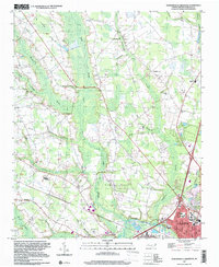
 1997 Rowland2000 Print · USGSNear the North Carolina and South Carolina border in the late nineties, this area showcases the intersection of small-town grids and coastal plain swamps. Genealogists can locate family landmarks like Mt Pelier Ch, Southside Sch, and the Rowland Cem.
 - 1997 Map of Southeast Lumberton, 2000 Print
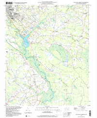 1997 Southeast Lumberton2000 Print · USGSSoutheast of Lumberton in the late nineties, the landscape was a mosaic of Carolina bays and riverside landings along the Lumber River. Genealogists and local historians can trace legacy sites like the Long Branch Sch, Robeson Memorial Park, and the Warwick Mill Pond area.
 - 1997 Map of Northwest Lumberton, 2000 Print
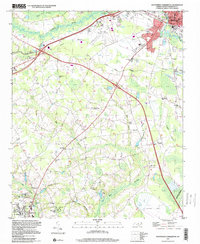
 1997 Northwest Lumberton2000 Print · USGSNorthwest of the Lumber River in the late nineties, this area shows the growth of the Robeson County seat alongside ancient swamp systems. Researchers can locate numerous family burial grounds and country churches like Mc Niell Cem, Saddletree Ch, and Magnolia High Sch.
 - 1997 Map of Saint Pauls, 2000 Print
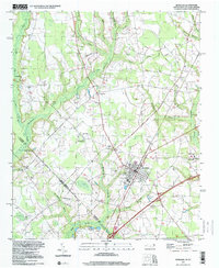
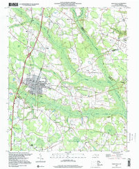 1997 Saint Pauls2000 Print · USGSCoastal plain wetlands and small-town North Carolina life intersect in the late nineties as the town of Saint Pauls expands. Local historians can trace family roots at McMillan Cem, find rural school sites like Pleasant View Sch, and follow the Old Grade Railroad.
End of results
Showing maps 1-6 of 6
Top cities of Robeson County
- Lumberton historical maps
- Fairmont historical maps
- Pembroke historical maps
- Maxton historical maps
- Rowland historical maps
- Parkton historical maps
See more
Frequently asked questions
- What are the different types of historical maps available for Robeson County?
- What is the oldest map of Robeson County?
- Where can I purchase historical maps of Robeson County for my home or office?
- Where can I download high-res historical maps of Robeson County?
- Are there historical topographic maps available for Robeson County?
- Is there historical aerial imagery available for Robeson County?
- Where are historical maps of Robeson County sourced from?