2000-2009 Maps of Robeson County, North Carolina
Explore 2 historic maps of Robeson County from 2000-2009. These maps offer a rare glimpse into what life looked like during the 2000s — showing old roads, neighborhoods, homes, and landmarks that have changed or disappeared over time.
Whether you're researching your family's past, planning a metal detecting trip, or studying how Robeson County's landscape evolved across the 2000s, these high-resolution maps are a powerful tool for exploring the history of this region.
- Focus on a specific era: All maps on this page are from the 2000s, giving you a focused view of this time period.
- See what’s changed: Compare century-old streets, trails, and buildings to today's modern landscape using overlays and satellite layers.
- Research with precision: Use these maps for genealogy, historical research, land use analysis, or educational projects.
- View, download, or print: Maps are fully viewable online in high resolution, and can be downloaded or printed for your own records.
Start exploring Robeson County's history through authentic maps from the 2000s. This is your window into the past.
Robeson County, NC maps
(2)- 2002 Map of Raeford
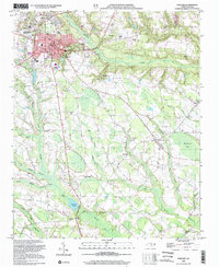 2002 Raeford2002 Print · USGSRaeford and the surrounding Hoke County wetlands are shown here at the turn of the millennium. Genealogists and local historians can locate community landmarks like McLaughlin Chapel, the Hoke County High Sch, and the Aberdeen and Rockfish RR.
 - 2002 Map of Pembroke
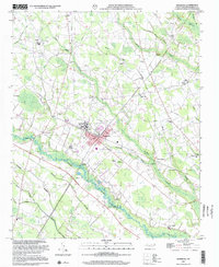 2002 Pembroke2002 Print · USGSPembroke and the surrounding swamplands of Robeson County are detailed here in the early 2000s. Genealogists can trace family landmarks and rural communities at Pembroke State Univ, Harpers Ferry, and Riverside Memorial Ch.
End of results
Showing maps 1-2 of 2
Top cities of Robeson County
- Lumberton historical maps
- Fairmont historical maps
- Pembroke historical maps
- Maxton historical maps
- Rowland historical maps
- Parkton historical maps
See more
Frequently asked questions
- What are the different types of historical maps available for Robeson County?
- What is the oldest map of Robeson County?
- Where can I purchase historical maps of Robeson County for my home or office?
- Where can I download high-res historical maps of Robeson County?
- Are there historical topographic maps available for Robeson County?
- Is there historical aerial imagery available for Robeson County?
- Where are historical maps of Robeson County sourced from?