1930s Maps of Brevard, North Carolina
Explore 3 historic maps of Brevard from the 1930s. These maps offer a rare glimpse into what life looked like during the 1930s — showing old roads, neighborhoods, homes, and landmarks that have changed or disappeared over time.
Whether you're researching your family's past, planning a metal detecting trip, or studying how Brevard's landscape evolved across the 1930s, these high-resolution maps are a powerful tool for exploring the history of this region.
- Focus on a specific era: All maps on this page are from the 1930s, giving you a focused view of this time period.
- See what’s changed: Compare century-old streets, trails, and buildings to today's modern landscape using overlays and satellite layers.
- Research with precision: Use these maps for genealogy, historical research, land use analysis, or educational projects.
- View, download, or print: Maps are fully viewable online in high resolution, and can be downloaded or printed for your own records.
Start exploring Brevard's history through authentic maps from the 1930s. This is your window into the past.
Brevard, NC maps
(3)- 1935 Map of Brevard
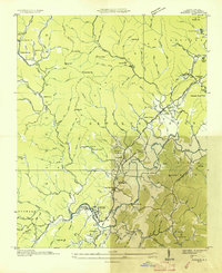
 1935 Brevard1935 Print · USGSBrevard and the French Broad River valley are shown here in the mid-1930s as the region balanced traditional mountain farming with new hydroelectric and recreational development. Genealogists and local historians can trace family-named sites like Breeses Mill, Gillespie Cem, and rural schools including Holden Sch.
 - 1935 Map of Rosman
 1935 Rosman1935 Print · USGSTransylvania County in the mid-1930s is a rugged landscape where the forks of the French Broad River meet amidst a flurry of New Deal activity. Genealogists can trace family landmarks like Whitmire Cem, Shoal Creek Sch, and the State Prison Camp near Calvert.
 - 1935 Map of Pisgah Forest
 1935 Pisgah Forest1935 Print · USGSThe headwaters of the French Broad River valley are shown in the mid-1930s as the national forest system expanded. Trace old family landmarks like Davidson River Cem and community hubs including Turkey Creek Ch and Penrose Sch.
End of results
Showing maps 1-3 of 3
Top cities near Brevard
- Asheville historical maps
- Fletcher historical maps
- Mills River historical maps
- Laurel Park historical maps
- Rosman historical maps
Top neighborhoods of Brevard
- Broadview Estates historical maps
- White Oaks historical maps
- Franklin Park historical maps
- Forest Hills historical maps
- McCrary Acres historical maps
- Pisgah Forest historical maps
Frequently asked questions
- What are the different types of historical maps available for Brevard?
- What is the oldest map of Brevard?
- Where can I purchase historical maps of Brevard for my home or office?
- Where can I download high-res historical maps of Brevard?
- Are there historical topographic maps available for Brevard?
- Is there historical aerial imagery available for Brevard?
- Where are historical maps of Brevard sourced from?