1940s Maps of Brevard, North Carolina
Explore 6 historic maps of Brevard from the 1940s. These maps offer a rare glimpse into what life looked like during the 1940s — showing old roads, neighborhoods, homes, and landmarks that have changed or disappeared over time.
Whether you're researching your family's past, planning a metal detecting trip, or studying how Brevard's landscape evolved across the 1940s, these high-resolution maps are a powerful tool for exploring the history of this region.
- Focus on a specific era: All maps on this page are from the 1940s, giving you a focused view of this time period.
- See what’s changed: Compare century-old streets, trails, and buildings to today's modern landscape using overlays and satellite layers.
- Research with precision: Use these maps for genealogy, historical research, land use analysis, or educational projects.
- View, download, or print: Maps are fully viewable online in high resolution, and can be downloaded or printed for your own records.
Start exploring Brevard's history through authentic maps from the 1940s. This is your window into the past.
Brevard, NC maps
(6)- 1945 Map of Brevard, 1956 Print
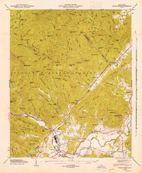
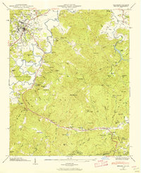 1945 Brevard1956 Print · USGSBrevard and the French Broad River valley are shown in the mid-1940s as a hub of mountain industry and education. Genealogists and historians can trace family plots at Gillespie Cem, visit the campus of Brevard College, or locate old landmarks like Breese Mill.2 unique versions available
 - 1945 Map of Rosman, 1957 Print
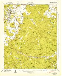
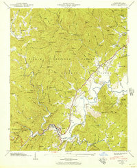 1945 Rosman1957 Print · USGSTransylvania County's river valleys and mountain gaps are captured here in the mid-1940s as the regional timber and rail economy thrived. Genealogists can locate family landmarks like Whitmire Cem, Zion Ch, and the State Prison Camp near Rosman.6 unique versions available
 - 1945 Map of Pisgah Forest, 1957 Print
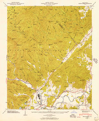 1945 Pisgah Forest1957 Print · USGSTransylvania and Henderson counties are captured here at the end of the war, where mountain industry and wilderness meet. Researchers can trace the legacy of Ecusta, find family burial sites at Davidson River Cem, and locate rural landmarks like English Chapel.2 unique versions available
 - 1946 Map of Rosman, 1947 Print
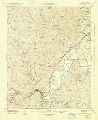 1946 Rosman1947 Print · USGSTransylvania County's mountain landscape comes to life in the mid-1940s as the railroad and river define the local economy. Researchers can locate family landmarks like the Whitmire Cem, rural pulpits such as Mt Moriah Ch, and the State Prison Camp near Rosman.
 - 1946 Map of Pisgah Forest, 1947 Print
 1946 Pisgah Forest1947 Print · USGSTransylvania County's timber and rail economy is on full display in the mid-1940s as the Southern Railway winds through the mountains. Genealogists and historians can trace community roots through English Chapel, Davidson River Cemetery, and the old Glade Creek School.
 - 1946 Map of Brevard, 1947 Print
 1946 Brevard1947 Print · USGSBrevard and the high mountain gaps of the Blue Ridge are captured here in the mid-1940s as a landscape of rural schools, summer camps, and river valleys. Genealogists can locate family-named cemeteries like Gillespie Cem and Glazener Cem or trace the early campus of Brevard College.2 unique versions available
End of results
Showing maps 1-6 of 6
Top cities near Brevard
- Asheville historical maps
- Fletcher historical maps
- Mills River historical maps
- Laurel Park historical maps
- Rosman historical maps
Top neighborhoods of Brevard
- Broadview Estates historical maps
- White Oaks historical maps
- Franklin Park historical maps
- Forest Hills historical maps
- McCrary Acres historical maps
- Pisgah Forest historical maps
Frequently asked questions
- What are the different types of historical maps available for Brevard?
- What is the oldest map of Brevard?
- Where can I purchase historical maps of Brevard for my home or office?
- Where can I download high-res historical maps of Brevard?
- Are there historical topographic maps available for Brevard?
- Is there historical aerial imagery available for Brevard?
- Where are historical maps of Brevard sourced from?