1960s Maps of Brevard, North Carolina
Explore 4 historic maps of Brevard from the 1960s. These maps offer a rare glimpse into what life looked like during the 1960s — showing old roads, neighborhoods, homes, and landmarks that have changed or disappeared over time.
Whether you're researching your family's past, planning a metal detecting trip, or studying how Brevard's landscape evolved across the 1960s, these high-resolution maps are a powerful tool for exploring the history of this region.
- Focus on a specific era: All maps on this page are from the 1960s, giving you a focused view of this time period.
- See what’s changed: Compare century-old streets, trails, and buildings to today's modern landscape using overlays and satellite layers.
- Research with precision: Use these maps for genealogy, historical research, land use analysis, or educational projects.
- View, download, or print: Maps are fully viewable online in high resolution, and can be downloaded or printed for your own records.
Start exploring Brevard's history through authentic maps from the 1960s. This is your window into the past.
Brevard, NC maps
(4)- 1960 Map of Knoxville
 1960 Knoxville1960 Print · USGSThe Southern Appalachians come alive in the 1950s, showing the intersection of new national park tourism and deep-rooted mountain industry. Trace old rail lines like the Clinchfield RR and find high-altitude landmarks from Mt Le Conte to the Cherokee Indian Reservation.2 unique versions available
 - 1964 Map of Knoxville
 1964 Knoxville1964 Print · USGSThe Southern Appalachians and Great Smokies are captured here during the mid-sixties, showing the rugged borderlands of Tennessee and North Carolina. Researchers can trace historic mountain routes like U S 441, the expanse of Pisgah National Forest, and the growing footprints of Asheville and Knoxville.
 - 1965 Map of Brevard, 1967 Print
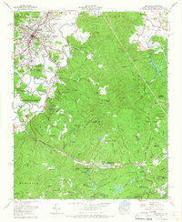 1965 Brevard1967 Print · USGSBrevard and the high country of the Blue Ridge appear here during the mid-sixties as the area's identity shifted toward education and mountain recreation. Researchers can trace local heritage through the Rosenwald School, Little River Chapel, and numerous family-named landmarks like McGaha Cem.5 unique versions available
 - 1965 Map of Pisgah Forest, 1967 Print
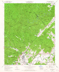 1965 Pisgah Forest1967 Print · USGSTransylvania and Henderson counties are captured here in the mid-sixties, where the industrial valley floor meets the mountain ridges. Researchers can trace family sites like Turkey Creek Cemetery and Osborne Cemetery or follow the Southern Railway through Pisgah Forest and Blantyre.4 unique versions available
End of results
Showing maps 1-4 of 4
Top cities near Brevard
- Asheville historical maps
- Fletcher historical maps
- Mills River historical maps
- Laurel Park historical maps
- Rosman historical maps
Top neighborhoods of Brevard
- Broadview Estates historical maps
- White Oaks historical maps
- Franklin Park historical maps
- Forest Hills historical maps
- McCrary Acres historical maps
- Pisgah Forest historical maps
Frequently asked questions
- What are the different types of historical maps available for Brevard?
- What is the oldest map of Brevard?
- Where can I purchase historical maps of Brevard for my home or office?
- Where can I download high-res historical maps of Brevard?
- Are there historical topographic maps available for Brevard?
- Is there historical aerial imagery available for Brevard?
- Where are historical maps of Brevard sourced from?