1990s Maps of Brevard, North Carolina
Explore 3 historic maps of Brevard from the 1990s. These maps offer a rare glimpse into what life looked like during the 1990s — showing old roads, neighborhoods, homes, and landmarks that have changed or disappeared over time.
Whether you're researching your family's past, planning a metal detecting trip, or studying how Brevard's landscape evolved across the 1990s, these high-resolution maps are a powerful tool for exploring the history of this region.
- Focus on a specific era: All maps on this page are from the 1990s, giving you a focused view of this time period.
- See what’s changed: Compare century-old streets, trails, and buildings to today's modern landscape using overlays and satellite layers.
- Research with precision: Use these maps for genealogy, historical research, land use analysis, or educational projects.
- View, download, or print: Maps are fully viewable online in high resolution, and can be downloaded or printed for your own records.
Start exploring Brevard's history through authentic maps from the 1990s. This is your window into the past.
Brevard, NC maps
(3)- 1997 Map of Rosman, 2001 Print
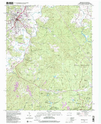
 1997 Rosman2001 Print · USGSThe French Broad River valley near the turn of the millennium remains a landscape of mountain ridges and secluded camps. Genealogists and local historians can trace legacy sites like Shady Grove Cem, Zion Ch, and the old NASA Tracking Station.
 - 1997 Map of Brevard, 2001 Print
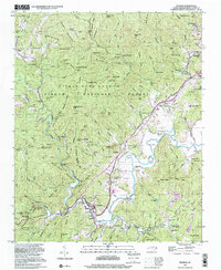
 1997 Brevard2001 Print · USGSBrevard and the surrounding Transylvania County highlands are shown here at the turn of the millennium as the area balanced forest preservation with residential growth. Researchers can trace historic family names and community centers through labels like Glazener Cem, Rosenwald School, and Little River Chapel.
 - 1997 Map of Pisgah Forest, 2001 Print
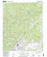 1997 Pisgah Forest2001 Print · USGSThe Brevard area and the headwaters of the French Broad River are captured here in the late twentieth century. Genealogists can trace family names at the McCall Cem and Davidson River Cem or locate centers like Cherry Village and the Penrose Sch.
End of results
Showing maps 1-3 of 3
Top cities near Brevard
- Asheville historical maps
- Fletcher historical maps
- Mills River historical maps
- Laurel Park historical maps
- Rosman historical maps
Top neighborhoods of Brevard
- Broadview Estates historical maps
- White Oaks historical maps
- Franklin Park historical maps
- Forest Hills historical maps
- McCrary Acres historical maps
- Pisgah Forest historical maps
Frequently asked questions
- What are the different types of historical maps available for Brevard?
- What is the oldest map of Brevard?
- Where can I purchase historical maps of Brevard for my home or office?
- Where can I download high-res historical maps of Brevard?
- Are there historical topographic maps available for Brevard?
- Is there historical aerial imagery available for Brevard?
- Where are historical maps of Brevard sourced from?