1930s Maps of Benson County, North Dakota
Explore 6 historic maps of Benson County from the 1930s. These maps offer a rare glimpse into what life looked like during the 1930s — showing old roads, neighborhoods, homes, and landmarks that have changed or disappeared over time.
Whether you're researching your family's past, planning a metal detecting trip, or studying how Benson County's landscape evolved across the 1930s, these high-resolution maps are a powerful tool for exploring the history of this region.
- Focus on a specific era: All maps on this page are from the 1930s, giving you a focused view of this time period.
- See what’s changed: Compare century-old streets, trails, and buildings to today's modern landscape using overlays and satellite layers.
- Research with precision: Use these maps for genealogy, historical research, land use analysis, or educational projects.
- View, download, or print: Maps are fully viewable online in high resolution, and can be downloaded or printed for your own records.
Start exploring Benson County's history through authentic maps from the 1930s. This is your window into the past.
Benson County, ND maps
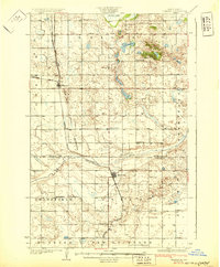
(6)- 1930 Map of Hamar
 1930 Hamar1930 Print · USGSBenson County and the Sheyenne River valley are captured here in the late 1920s as the rail-and-river economy flourished. Genealogists can trace the rural communities around Warwick and Hamar, locating landmarks like the Jerusalem Ch and Lookout Mtn.
 - 1931 Map of Oberon
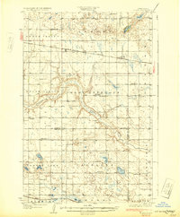
 1931 Oberon1931 Print · USGSThe North Dakota prairie unfolds in the late twenties as a network of rail-side towns and rural townships north of the Sheyenne River. Genealogists and historians can trace the exact locations of Grandfield Ch, St Gertrudes Ch, and several numbered country schools.2 unique versions available
 - 1931 Map of Tokio
 1931 Tokio1931 Print · USGSThe southern shores of Devils Lake come into focus in the late twenties, detailing the area around Fort Totten P O and the Devils Lake Indian Reservation. Genealogists can trace local landmarks like Devils Heart and numerous rural schoolhouses including School No 2 and School No 4.2 unique versions available
 - 1931 Map of Devils Lake
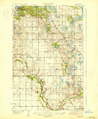
 1931 Devils Lake1931 Print · USGSThe North Dakota prairie and its complex lake systems are captured here in the late 1920s. Genealogists and historians can trace early rural life at Grand Harbor, the military grounds of CAMP GRAFTON, and numerous local sites like Consolidated School No 1.3 unique versions available
 - 1932 Map of Flora
 1932 Flora1932 Print · USGSBenson and Wells Counties are captured here between the wars, when the prairie was a network of small school districts and railroad sidings. Trace the early township life of the region through landmarks like Monterey Town Hall, Stony Lake, and the Maddock Cem.2 unique versions available
 - 1932 Map of Grahams Island
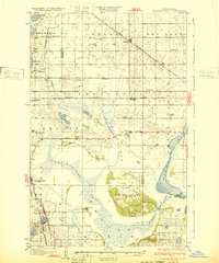 1932 Grahams Island1932 Print · USGSDevils Lake and Grahams Island are seen here in the early 1930s as a complex network of prairie schools and railroads. Genealogists can locate family landmarks like St Paul Cem, Antiochia Ch, and the many numbered schools scattered across Normania and Coulee.
End of results
Showing maps 1-6 of 6
Top cities of Benson County
- Maddock historical maps
- Leeds historical maps
- Minnewaukan historical maps
- Esmond historical maps
- Hesper historical maps
- Oberon historical maps
See more
Frequently asked questions
- What are the different types of historical maps available for Benson County?
- What is the oldest map of Benson County?
- Where can I purchase historical maps of Benson County for my home or office?
- Where can I download high-res historical maps of Benson County?
- Are there historical topographic maps available for Benson County?
- Is there historical aerial imagery available for Benson County?
- Where are historical maps of Benson County sourced from?