1950s Maps of Benson County, North Dakota
Explore 49 historic maps of Benson County from the 1950s. These maps offer a rare glimpse into what life looked like during the 1950s — showing old roads, neighborhoods, homes, and landmarks that have changed or disappeared over time.
Whether you're researching your family's past, planning a metal detecting trip, or studying how Benson County's landscape evolved across the 1950s, these high-resolution maps are a powerful tool for exploring the history of this region.
- Focus on a specific era: All maps on this page are from the 1950s, giving you a focused view of this time period.
- See what’s changed: Compare century-old streets, trails, and buildings to today's modern landscape using overlays and satellite layers.
- Research with precision: Use these maps for genealogy, historical research, land use analysis, or educational projects.
- View, download, or print: Maps are fully viewable online in high resolution, and can be downloaded or printed for your own records.
Start exploring Benson County's history through authentic maps from the 1950s. This is your window into the past.
Benson County, ND maps
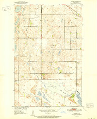
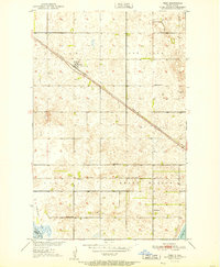
(49)- 1950 Map of Oberon SW
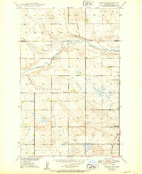 1950 Oberon SW1950 Print · USGSMid-century Eddy County remains a landscape of traditional township borders and scattered prairie schoolhouses. Genealogists can locate Grandfield Ch and Town Hall, or trace the Northern Pacific tracks as they cross the Sheyenne River.2 unique versions available
 - 1950 Map of Wellsburg
 1950 Wellsburg1950 Print · USGSThe mid-century plains of Wells County are defined here by the winding Sheyenne River and the critical Great Northern rail corridor. Genealogists can locate several rural landmarks including Wellsburg, Odessa Sch No 1, and Butte De Morale.
 - 1950 Map of Sheyenne
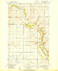
 1950 Sheyenne1950 Print · USGSMid-century Eddy County comes into focus as a network of rural schools and rail-side settlements in the years following the war. Genealogists and historians can trace the foundations of Sheyenne and Divide, along with local landmarks like Holy Cross Cem and Rose Hill Sch.3 unique versions available
 - 1950 Map of Tokio SW
 1950 Tokio SW1950 Print · USGSMid-century Eddy County is captured here as a landscape of prairie schoolhouses and river bends before modern consolidation. Family researchers can trace local landmarks like Bourett Cem, School No 4, and the winding Sheyenne River.
 - 1950 Map of Tokio, 1952 Print
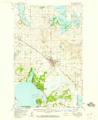
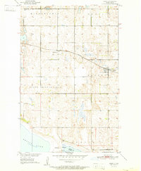
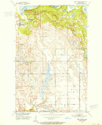
 1950 Tokio1952 Print · USGSBenson County at the start of the 1950s was a landscape defined by the shifting waters of the Devils Lake basin and the lifeline of the railroad. Researchers can trace the mid-century footprints of Saint Michael and Tokio, or find local landmarks like Wood Lake Ch and Devils Heart Butte.
 - 1950 Map of Grahams Island, 1959 Print
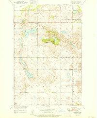
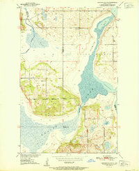
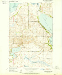
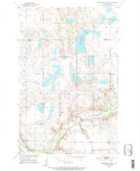
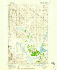 1950 Grahams Island1959 Print · USGSDevils Lake and its rugged shoreline dominate this mid-century survey of Benson and Ramsey counties. Local historians can trace the legacy of rural education and faith at School No 5, St Paul Cem, and the Old Military Reservation.2 unique versions available
 - 1950 Map of Devils Lake, 1959 Print
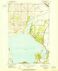
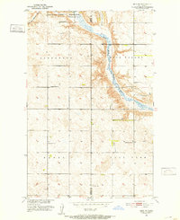
 1950 Devils Lake1959 Print · USGSDevils Lake and the surrounding North Dakota prairies are captured mid-century, showing a landscape shaped by rail lines and regional institutions. Genealogists can locate several schools and cemeteries, including the Grand Harbor Cem, Grove Sch, and the military grounds at Camp Grafton.2 unique versions available
 - 1950 Map of Oberon, 1960 Print
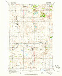 1950 Oberon1960 Print · USGSBenson and Eddy Counties are captured here at mid-century, defined by a landscape of prairie schoolhouses and the winding Sheyenne River. Genealogists can trace the locations of family landmarks like Holy Cross Cem, St Jerome Ch, and the town of Oberon along the Northern Pacific rail line.
 - 1950 Map of Devils Lake Mountain, 1978 Print
 1950 Devils Lake Mountain1978 Print · USGSRamsey County and the surrounding prairies are captured here at mid-century as rural life centered around small township hubs. Genealogists can locate the Odessa Cem and early landmarks like School No 2 near the shores of East Devils Lake.
 - 1951 Map of Crow Hill
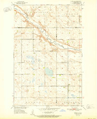
 1951 Crow Hill1951 Print · USGSBenson County was a landscape of small school districts and rural parishes in the early fifties. Genealogists and historians can trace the foundations of this community through landmarks like St Jerome Ch, Plainview Sch No 2, and the shores of Twin Lakes.2 unique versions available
 - 1951 Map of Oberon
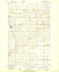
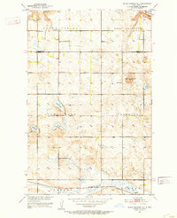
 1951 Oberon1951 Print · USGSBenson County prairie life is centered on the railroad in the early fifties, where the tracks connect small rural hubs. Researchers can trace the Old Indian Reservation Boundary and locate family landmarks like Hillside Cem and Oberon.2 unique versions available
 - 1951 Map of Crary
 1951 Crary1951 Print · USGSRamsey County's prairie landscape was still a patchwork of small school districts and family farms in the mid-twentieth century. Trace local genealogy and rail history through the Great Northern tracks, Crary Cem, and rural landmarks like School No 1.
 - 1951 Map of Flora SE
 1951 Flora SE1951 Print · USGSThe Sheyenne River valley and the surrounding townships of Wells and Benson counties are recorded here in the early fifties. Genealogists and historians can locate rural landmarks such as Eden Ch, Augustana Ch, and multiple schoolhouses like School No 1.2 unique versions available
 - 1951 Map of Devils Lake Mountain
 1951 Devils Lake Mountain1951 Print · USGSThe rural landscapes of Ramsey and Nelson counties are captured here in the early fifties, showing the sparse prairie settlements of Odessa and Minco. Genealogists can trace family footprints near School No 2 and the Odessa Cem, while the Old Indian Reservation Boundary marks a significant historical line.
 - 1951 Map of Devils Lake
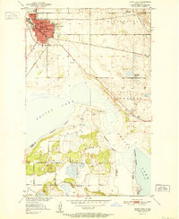 1951 Devils Lake1951 Print · USGSDevils Lake in the early fifties shows a thriving regional center defined by its institutions and the rail lines of the Great Northern. Researchers can trace the footprints of the Odd Fellows Home, St Marys Academy, and several rural sites like School No 1.2 unique versions available
 - 1951 Map of Grahams Island
 1951 Grahams Island1951 Print · USGSGrahams Island and the intricate bays of Devils Lake are captured here in the early fifties, showing the region's rural character. Trace the Old Military Reservation Boundary or locate local landmarks like School No 1 and School No 2.2 unique versions available
 - 1951 Map of Tilden
 1951 Tilden1951 Print · USGSThe Benson and Ramsey county borderlands come alive in this mid-century survey of the North Dakota prairie. Genealogists and historians can trace the foundations of rural life through the locations of Antiochia Ch, Presbyterian Cem, and the village of Tilden.
 - 1951 Map of Camp Grafton
 1951 Camp Grafton1951 Print · USGSDevils Lake at the mid-century reveals a landscape of military training and conservation efforts on the shores of Ramsey and Benson counties. Researchers can trace the Great Northern rail line past Fort Totten Station and find local landmarks like Grove Sch and Camp Grafton.2 unique versions available
 - 1951 Map of Free Peoples Lake
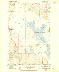
 1951 Free Peoples Lake1951 Print · USGSBenson and Ramsey Counties show their mid-century rural character before shifting water levels altered the landscape. Genealogists and local historians can trace specific district boundaries and find the locations of early rural landmarks like Free Peoples School, School No 8, and Free Peoples Lake.2 unique versions available
 - 1951 Map of Minnewaukan East
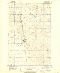
 1951 Minnewaukan East1951 Print · USGSThe Benson County shoreline in the early 1950s shows the complex water levels of Devils Lake and the rural reaches of Minnewaukan. Genealogists and local historians can locate early landmarks like School No 1, the Northern Pacific rail line, and family landmarks like Sams Hill.
 - 1951 Map of Penn
 1951 Penn1951 Print · USGSRamsey County was a landscape of rail-dependent prairie towns and scattered schoolhouses in the early fifties. Genealogists and local historians can trace the foundations of the Penn community, find St Paul Cem, and locate rural landmarks like Bay School.
 - 1951 Map of Horseshoe Lake, 1952 Print
 1951 Horseshoe Lake1952 Print · USGSEddy and Benson counties in the early fifties reveal a landscape defined by glacial lakes and the historical Old Indian Reservation Boundary. Genealogists can locate rural schoolhouses such as School No 2 and the School No 3 (Abandoned) near the Sheyenne River.
 - 1951 Map of Selz NE, 1952 Print
 1951 Selz NE1952 Print · USGSBenson and Pierce Counties are captured here in the early fifties, showing a rural landscape defined by the winding North Fork Sheyenne River. Genealogists and local historians can trace schoolhouse locations like Strasburg Sch No 2 or visit the site of St Boniface Cem.
 - 1951 Map of Black Hammer Hill, 1953 Print
 1951 Black Hammer Hill1953 Print · USGSBenson and Wells Counties appear here in the early fifties, showing a prairie landscape of isolated farmsteads and township schools. Genealogists and local historians can trace the foundations of Bremen and find rural landmarks like Viking Ch and Trinity Cem.2 unique versions available
 - 1951 Map of Fort Totten, 1953 Print
 1951 Fort Totten1953 Print · USGSBenson and Ramsey Counties were undergoing significant transitions in the early fifties along the shores of Devils Lake. Genealogists and local historians can locate the Fort Totten Indian Agency, the Great Northern rail line, and rural landmarks like Lone Tree Sch No 1.2 unique versions available
Showing maps 1-25 of 49
Top cities of Benson County
- Maddock historical maps
- Leeds historical maps
- Minnewaukan historical maps
- Esmond historical maps
- Hesper historical maps
- Oberon historical maps
See more
Frequently asked questions
- What are the different types of historical maps available for Benson County?
- What is the oldest map of Benson County?
- Where can I purchase historical maps of Benson County for my home or office?
- Where can I download high-res historical maps of Benson County?
- Are there historical topographic maps available for Benson County?
- Is there historical aerial imagery available for Benson County?
- Where are historical maps of Benson County sourced from?