1940s Maps of Benson County, North Dakota
Explore 3 historic maps of Benson County from the 1940s. These maps offer a rare glimpse into what life looked like during the 1940s — showing old roads, neighborhoods, homes, and landmarks that have changed or disappeared over time.
Whether you're researching your family's past, planning a metal detecting trip, or studying how Benson County's landscape evolved across the 1940s, these high-resolution maps are a powerful tool for exploring the history of this region.
- Focus on a specific era: All maps on this page are from the 1940s, giving you a focused view of this time period.
- See what’s changed: Compare century-old streets, trails, and buildings to today's modern landscape using overlays and satellite layers.
- Research with precision: Use these maps for genealogy, historical research, land use analysis, or educational projects.
- View, download, or print: Maps are fully viewable online in high resolution, and can be downloaded or printed for your own records.
Start exploring Benson County's history through authentic maps from the 1940s. This is your window into the past.
Benson County, ND maps
(3)- 1941 Map of Selz
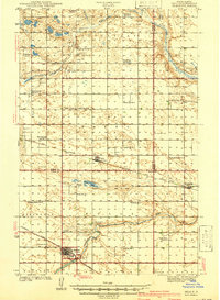 1941 Selz1941 Print · USGSPierce and Wells Counties are shown in the late thirties as a landscape of rural school districts and bustling rail towns. Genealogists can locate family landmarks such as the Sheyenne River Academy, St Anthony Cem, and dozens of numbered country schools.2 unique versions available
 - 1943 Map of Maddock, 1963 Print
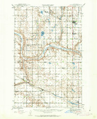 1943 Maddock1963 Print · USGSBenson and Wells counties are shown in detail during the 1940s, when the prairie was dotted with localized school districts and rural parishes. Genealogists can trace family footprints at North Viking Cem or find the sites of East Fram Sch No 4 and Heimdal.
 - 1945 Map of Maddock
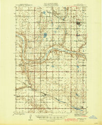 1945 Maddock1945 Print · USGSBenson and Wells counties in the mid-1940s are defined by a robust network of prairie towns and competing rail lines. Researchers can trace rural life through numerous landmark schools and churches, from Maddock and Heimdal to Klara Church and East Fram School No 4.
End of results
Showing maps 1-3 of 3
Top cities of Benson County
- Maddock historical maps
- Leeds historical maps
- Minnewaukan historical maps
- Esmond historical maps
- Hesper historical maps
- Oberon historical maps
See more
Frequently asked questions
- What are the different types of historical maps available for Benson County?
- What is the oldest map of Benson County?
- Where can I purchase historical maps of Benson County for my home or office?
- Where can I download high-res historical maps of Benson County?
- Are there historical topographic maps available for Benson County?
- Is there historical aerial imagery available for Benson County?
- Where are historical maps of Benson County sourced from?