1980s Maps of Benson County, North Dakota
Explore 5 historic maps of Benson County from the 1980s. These maps offer a rare glimpse into what life looked like during the 1980s — showing old roads, neighborhoods, homes, and landmarks that have changed or disappeared over time.
Whether you're researching your family's past, planning a metal detecting trip, or studying how Benson County's landscape evolved across the 1980s, these high-resolution maps are a powerful tool for exploring the history of this region.
- Focus on a specific era: All maps on this page are from the 1980s, giving you a focused view of this time period.
- See what’s changed: Compare century-old streets, trails, and buildings to today's modern landscape using overlays and satellite layers.
- Research with precision: Use these maps for genealogy, historical research, land use analysis, or educational projects.
- View, download, or print: Maps are fully viewable online in high resolution, and can be downloaded or printed for your own records.
Start exploring Benson County's history through authentic maps from the 1980s. This is your window into the past.
Benson County, ND maps
(5)- 1981 Map of New Rockford
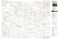 1981 New Rockford1981 Print · USGSCentral North Dakota's prairie heartland is captured here in the early eighties, showing a landscape defined by the Burlington Northern rail lines and sprawling waterfowl refuges. Genealogists and local historians can trace the foundations of New Rockford, Maddock, and Fessenden, alongside landmarks like Tomlinson Field and the Fort Totten Indian Reservation.
 - 1985 Map of Devils Lake
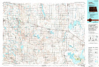
 1985 Devils Lake1985 Print · USGSThe Ramsey County lake region is captured here in the mid-1980s as a vital hub of wildlife management and grain transport. Researchers can trace the sprawling boundaries of the Fort Totten Indian Reservation and locate local landmarks like Lake Region Jr College and Whitman Dam.
 - 1985 Map of Stump Lake
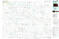 1985 Stump Lake1985 Print · USGSNorth Dakota's lake country in the mid-eighties shows a landscape shaped by the Burlington Northern rail line and tribal lands. Genealogists and historians can locate family sites near Warwick, Tokio, and the Fort Totten Indian Reservation.2 unique versions available
 - 1985 Map of Leeds, 1994 Print
 1985 Leeds1994 Print · USGSBenson and Ramsey counties are shown during the mid-eighties as a patchwork of prairie agriculture and vital wetland habitats. Researchers can locate family roots at Knox Cem, trace the Soo Line rail corridors, or explore the fringes of Devils Lake.
 - 1986 Map of Wellsburg
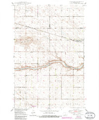 1986 Wellsburg1986 Print · USGSCentral North Dakota’s prairie landscape is captured here in the mid-1980s, centered on the railroad siding and river bends near Wellsburg. Genealogists and local historians can locate several rural schoolhouses, including Odessa Sch No 1 and South Fram Sch, alongside the prominent Butte De Morale.
End of results
Showing maps 1-5 of 5
Top cities of Benson County
- Maddock historical maps
- Leeds historical maps
- Minnewaukan historical maps
- Esmond historical maps
- Hesper historical maps
- Oberon historical maps
See more
Frequently asked questions
- What are the different types of historical maps available for Benson County?
- What is the oldest map of Benson County?
- Where can I purchase historical maps of Benson County for my home or office?
- Where can I download high-res historical maps of Benson County?
- Are there historical topographic maps available for Benson County?
- Is there historical aerial imagery available for Benson County?
- Where are historical maps of Benson County sourced from?