1900s (20th Century) Maps of Lansford, North Dakota
Explore 9 historic maps of Lansford from the 1900s (20th Century). These maps offer a rare glimpse into what life looked like during the 1900s — showing old roads, neighborhoods, homes, and landmarks that have changed or disappeared over time.
Whether you're researching your family's past, planning a metal detecting trip, or studying how Lansford's landscape evolved across the 1900s, these high-resolution maps are a powerful tool for exploring the history of this region.
- Focus on a specific era: All maps on this page are from the 1900s, giving you a focused view of this time period.
- See what’s changed: Compare century-old streets, trails, and buildings to today's modern landscape using overlays and satellite layers.
- Research with precision: Use these maps for genealogy, historical research, land use analysis, or educational projects.
- View, download, or print: Maps are fully viewable online in high resolution, and can be downloaded or printed for your own records.
Start exploring Lansford's history through authentic maps from the 1900s. This is your window into the past.
Lansford, ND maps
(9)- 1948 Map of Lansford, 1955 Print
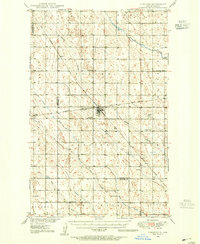 1948 Lansford1955 Print · USGSNorth Dakota's northern prairie is captured here during the post-war era, showing a landscape defined by vital rail junctions and rural schoolhouses. Researchers can trace family history through sites like Lansford, St Johns Cem, and Graham Sch.3 unique versions available
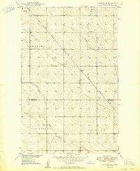
 - 1948 Map of Lansford SW, 1976 Print
 1948 Lansford SW1976 Print · USGSRenville and Bottineau counties appear here in the late 1940s, showing a prairie landscape shaped by the Soo Line and seasonal creeks. Researchers can locate the Lansford Cem and rural landmarks like Olsen School and Graham School.
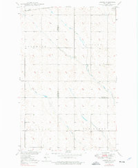
 - 1949 Map of Lansford NW
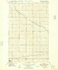
 1949 Lansford NW1949 Print · USGSNorth Dakota's northern plains are captured here in the late 1940s, highlighting a landscape defined by the intersection of major rail lines. Researchers can trace the routes of the Great Northern and locate community sites like Blaine Sch and St Johns Cem.
 - 1949 Map of Lansford SW
 1949 Lansford SW1949 Print · USGSNorth Dakota's northern plains are captured here in the late 1940s as a landscape of structured townships and vital rail connections. Researchers can locate rural landmarks like the Olsen School and Graham School or trace the Soo Line through Lansford.
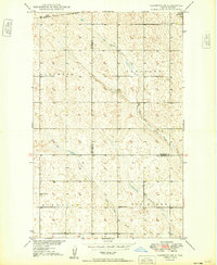
 - 1949 Map of Lansford SE
 1949 Lansford SE1949 Print · USGSPrairie life in the Bottineau and Renville county borderlands is documented here just after the war. You can trace the Great Northern rail line connecting Lansford and Forfar or locate rural landmarks like School No 2 and Spring Coulee.
 - 1949 Map of Lansford NE
 1949 Lansford NE1949 Print · USGSThe prairie landscape of north-central North Dakota is captured here just after the war, centered on the rural townships of Mount Rose and Renville. Genealogists and historians can trace the Minneapolis St Paul and Sault Ste Marie rail line past Lansford to the Renville Cem.
 - 1950 Map of Lansford
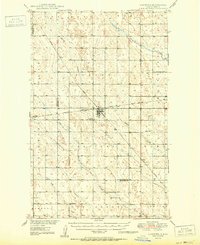 1950 Lansford1950 Print · USGSNorth Dakota's northern prairie was a bustling network of rail and rural education during the mid-century. Researchers can trace the heritage of Lansford through its numerous country schoolhouses like Graham Sch and rail-line stops such as Forfar.
 - 1954 Map of Minot, 1964 Print
 1954 Minot1964 Print · USGSNorth Dakota's northern borderlands are captured here in the mid-fifties, showing a landscape defined by the winding Souris River and the rise of the Turtle Mountains. Genealogists can locate family-named sidings like Hurd Siding and Truro Siding alongside the vital Great Northern rail lines.3 unique versions available
 - 1958 Map of Minot
 1958 Minot1958 Print · USGSNorthern North Dakota is shown here during the mid-fifties, dominated by the rail-driven growth of Minot and the surrounding grain-farming prairie. Genealogists can trace family connections to border towns like Westhope or explore the vast reaches of the Turtle Mountains.
End of results
Showing maps 1-9 of 9
Top cities near Lansford
Frequently asked questions
- What are the different types of historical maps available for Lansford?
- What is the oldest map of Lansford?
- Where can I purchase historical maps of Lansford for my home or office?
- Where can I download high-res historical maps of Lansford?
- Are there historical topographic maps available for Lansford?
- Is there historical aerial imagery available for Lansford?
- Where are historical maps of Lansford sourced from?