Old Maps of Burleigh County, North Dakota for Academic Research
Study the evolution of Burleigh County with 287 high-resolution historic maps. Whether you're teaching, researching, or modeling changes in land use, these maps provide essential visual documentation of urban, environmental, and geographic change.
- Analyze long-term change: Track patterns in development, transportation, and natural features.
- Ideal for environmental or urban studies: Support academic projects with primary historical map data.
- Use in the classroom or lab: Educators and researchers rely on these maps to bring historical context to life.
These maps are a powerful tool for teaching, research, and visualizing how Burleigh County has changed over the decades.
Burleigh County, ND maps
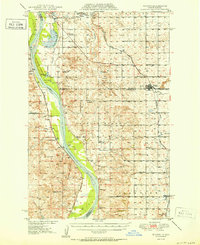
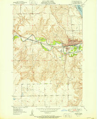
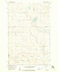
(287)- 1907 Map of Bismarck
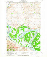
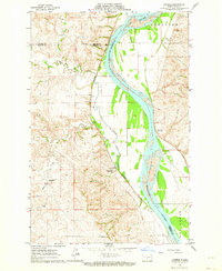
 1907 Bismarck1907 Print · USGSThe Missouri River corridor at the turn of the century shows North Dakota's capital and rail hubs in their formative years. Researchers can trace early land divisions and transport routes like the Fort Yates Stage Road and landmarks such as Fort Lincoln or St Anthony.2 unique versions available
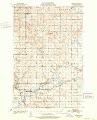
 - 1950 Map of Wilton
 1950 Wilton1950 Print · USGSThe Missouri River breaks and upland prairies of McLean and Burleigh counties are mapped here at mid-century. Genealogists can locate family names via numerous rural landmarks, from Painted Woods Ch and Wing Cem to several local schoolhouses like School No 2.2 unique versions available
 - 1950 Map of Bismarck
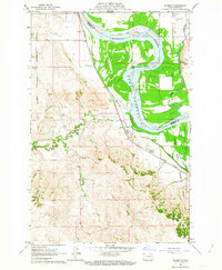
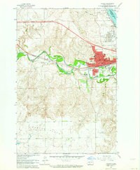
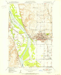 1950 Bismarck1950 Print · USGSBismarck and Mandan face one another across the Missouri River at a time when the capital's historic military roots and modern rail infrastructure were both clearly visible. Genealogists and historians can trace the State Prison Farm, Fraine Barracks, and old Indian Mounds.
 - 1951 Map of Menoken SW
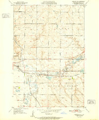 1951 Menoken SW1951 Print · USGSBismarck's eastern periphery in the early fifties shows a rural landscape on the cusp of change, where major railroads and country schools meet. Researchers can trace the path of the Northern Pacific, locate the Fairview Cem, or find the State Penitentiary.
 - 1951 Map of Bismarck
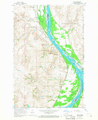
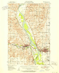 1951 Bismarck1951 Print · USGSBismarck and Mandan sit at the heart of the Missouri River valley at mid-century, just as the post-war era began to reshape the North Dakota capital. Genealogists and local historians can trace legacy landmarks like St Marys Cem, the Great Plains Experiment Station, and numerous rural schoolhouses such as Sunny Sch.
 - 1951 Map of Mandan
 1951 Mandan1951 Print · USGSMid-century Mandan and the Missouri River floodplain come alive in this detailed mid-century survey. Genealogists and local historians can trace the foundations of the community through the State Training School, the rural Sunny Sch, and the high-elevation Custer Flats.
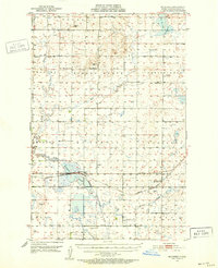
 - 1951 Map of Menoken, 1952 Print
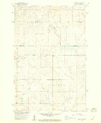
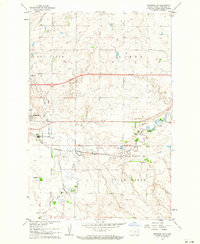
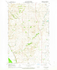
 1951 Menoken1952 Print · USGSMid-century Burleigh County comes into focus as a landscape of prairie townships and vital transportation links. Trace the rural roots of the region through landmarks like the State Penitentiary, Menoken (Burleigh Sta), and Swedish Cem.2 unique versions available
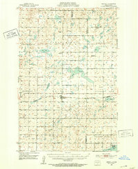
 - 1951 Map of McKenzie, 1952 Print
 1951 McKenzie1952 Print · USGSMid-century Burleigh County comes alive here as a landscape of prairie townships and rail-side growth. Trace family roots at Sibley Cem or explore the early infrastructure of McKenzie and the Northern Pacific railroad near McKenzie Slough.
 - 1951 Map of Driscoll, 1953 Print
 1951 Driscoll1953 Print · USGSThe Burleigh County prairie comes alive in the early fifties, centered on the railroad town of Driscoll. Genealogists and local historians can trace the locations of Zion Ch, the Chaska Historic Site, and numerous rural schools like School No 4.
 - 1954 Map of Bismarck, 1967 Print
 1954 Bismarck1967 Print · USGSBismarck and the Missouri River basin are shown in the mid-1960s as the Oahe Reservoir reshaped the valley. Genealogists can trace family-named landmarks like Dog Tooth Buttes and small prairie settlements such as Fort Yates, Selfridge, and Brisbane.2 unique versions available
 - 1954 Map of McClusky, 1968 Print
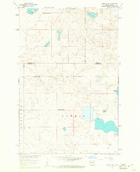
 1954 McClusky1968 Print · USGSCentral North Dakota was undergoing a profound transformation in the fifties as the newly formed Lake Sakakawea reshaped the Missouri River valley. Genealogists and historians can trace rail-town development along the Soo Line and locate historic markers like Garrison Dam or the Lewis and Clark Trail.3 unique versions available
 - 1958 Map of Bismarck
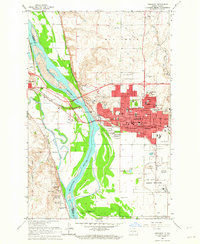
 1958 Bismarck1958 Print · USGSCentral North Dakota in the late fifties is defined by the Missouri River and the sprawling Standing Rock Indian Reservation. Genealogists and historians can trace rail-line outposts like Sedalia Siding or explore local landmarks like Saint Anthony and Fort Lincoln State Park/Museum.
 - 1958 Map of McClusky
 1958 McClusky1958 Print · USGSCentral North Dakota was undergoing a profound change in the late fifties as the Garrison Reservoir filled behind its massive new dam. Trace the early layout of Riverdale, the Lewis and Clark Trail, and the vanishing rail stops of the Northern Pacific.
 - 1959 Map of Mercer SW, 1960 Print
 1959 Mercer SW1960 Print · USGSNorth Dakota's prairie borders are captured here in the late fifties, showing the rural crossroads of three counties. Genealogists and historians can trace old homestead districts through Park Sch No 2, Bethel Cem, and the path of Painted Woods Creek.2 unique versions available
 - 1959 Map of Mercer SE, 1960 Print
 1959 Mercer SE1960 Print · USGSThe prairie border of Burleigh and Sheridan counties is captured here in the late fifties, showcasing a rural landscape of scattered homesteads and small-town institutions. Genealogists can trace the locations of Alta Ch and several local landmarks like Johns Lake Sch No 1 and Pleasant View Sch.2 unique versions available
 - 1960 Map of Horse Lake, 1961 Print
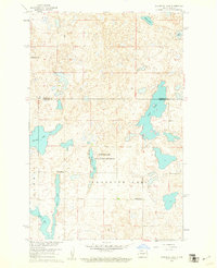
 1960 Horse Lake1961 Print · USGSThe prairie pothole region of North Dakota is captured here in the early sixties at the Sheridan and Burleigh County line. Genealogists can locate specific rural landmarks like Johns Lake Ch, Schrunk Sch No 1, and Johns Lake Sch No 3.2 unique versions available
 - 1960 Map of Florence Lake, 1961 Print
 1960 Florence Lake1961 Print · USGSThe prairie pothole region of Burleigh and Sheridan Counties comes to life in the early sixties, showing a landscape shaped by water and wind. Genealogists and local historians can locate early rural schools like Whittaker Sch and School No 2 among the shores of Salt Lake.
 - 1962 Map of Sugarloaf Butte, 1963 Print
 1962 Sugarloaf Butte1963 Print · USGSThe Missouri River bottoms south of Bismarck were in transition during the early sixties as reservoir waters began to rise. Genealogists and historians can trace the Old Fort Rice Military Road, locate Manning School No 1, and find the Stewardsdale Cem.
 - 1962 Map of Schmidt, 1963 Print
 1962 Schmidt1963 Print · USGSThe Missouri River valley south of Bismarck underwent a major transition in the early sixties as the rising waters of the Oahe Reservoir began to reshape the landscape. Local historians can trace the boundaries of the Old Fort Lincoln Military Reservation and locate rural landmarks like Bonanza Sch No 4 and Schmidt.2 unique versions available
 - 1962 Map of Menoken SW, 1964 Print
 1962 Menoken SW1964 Print · USGSBismarck and the surrounding Gibbs Township are seen here in the early sixties as the city expanded eastward toward the Apple Creek valley. Genealogists and researchers can locate the State Penitentiary, rural schools like Wilson Sch, and the Fairview Cem alongside the Northern Pacific tracks.2 unique versions available
 - 1962 Map of Bismarck, 1964 Print
 1962 Bismarck1964 Print · USGSBismarck and Mandan face each other across the Missouri River in the early 1960s during a period of significant capital expansion. Trace the historical roots of the region at the Fort Lincoln Historic Site Ruins, the Capitol grounds, and the Northern Pacific rail yards.3 unique versions available
 - 1962 Map of Harmon, 1964 Print
 1962 Harmon1964 Print · USGSThe Missouri River valley north of Bismarck comes alive in the early sixties, showing a landscape of riverside settlements and active rail lines. Genealogists and historians can trace the Northern Pacific tracks through Harmon or locate Square Butte School No 1 and the Double Ditch Indian Village.2 unique versions available
 - 1962 Map of Burnt Butte, 1964 Print
 1962 Burnt Butte1964 Print · USGSThe rolling prairie of Burleigh County is captured here in the early sixties, showing a landscape of scattered buttes and rural townships. Researchers can find old educational sites like Burnt Creek Sch No 1 and trace early settlements at Midway and Arnold.2 unique versions available
 - 1962 Map of Mandan, 1964 Print
 1962 Mandan1964 Print · USGSMandan was a bustling rail and energy hub in the early sixties where the Heart and Missouri rivers meet. Genealogists and historians can trace the town's growth through its many neighborhood institutions, including St Joseph Sch, the State Training School, and Custer Sch No 1.2 unique versions available
 - 1966 Map of Price, 1967 Print
 1966 Price1967 Print · USGSThe Missouri River valley in Oliver County during the mid-1960s shows a landscape of river-oriented settlement and rail transport. Genealogists and historians can trace the foundations of Price, locate Price Sch, and explore landmarks like Square Buttes.2 unique versions available
Showing maps 1-25 of 287
Top cities of Burleigh County
- Bismarck historical maps
- Lincoln historical maps
- Sterling historical maps
- Driscoll historical maps
- Menoken historical maps
- McKenzie historical maps
See more
Frequently asked questions
- What are the different types of historical maps available for Burleigh County?
- What is the oldest map of Burleigh County?
- Where can I purchase historical maps of Burleigh County for my home or office?
- Where can I download high-res historical maps of Burleigh County?
- Are there historical topographic maps available for Burleigh County?
- Is there historical aerial imagery available for Burleigh County?
- Where are historical maps of Burleigh County sourced from?