1970s Maps of Divide County, North Dakota
Explore 3 historic maps of Divide County from the 1970s. These maps offer a rare glimpse into what life looked like during the 1970s — showing old roads, neighborhoods, homes, and landmarks that have changed or disappeared over time.
Whether you're researching your family's past, planning a metal detecting trip, or studying how Divide County's landscape evolved across the 1970s, these high-resolution maps are a powerful tool for exploring the history of this region.
- Focus on a specific era: All maps on this page are from the 1970s, giving you a focused view of this time period.
- See what’s changed: Compare century-old streets, trails, and buildings to today's modern landscape using overlays and satellite layers.
- Research with precision: Use these maps for genealogy, historical research, land use analysis, or educational projects.
- View, download, or print: Maps are fully viewable online in high resolution, and can be downloaded or printed for your own records.
Start exploring Divide County's history through authentic maps from the 1970s. This is your window into the past.
Divide County, ND maps
(3)- 1974 Map of Wildrose, 1977 Print
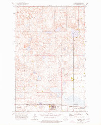 1974 Wildrose1977 Print · USGSWildrose and the Divide-Williams county line appear here in the mid-seventies, showing a landscape shaped by rail and agriculture. Researchers can trace the Burlington Northern corridor and find local landmarks like Grace Cem and Willow Lake.
 - 1974 Map of Hamlet, 1977 Print
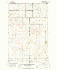 1974 Hamlet1977 Print · USGSThe northwestern prairie of North Dakota near the Divide and Williams county line is shown here in the mid-1970s. Researchers can locate the railroad settlement of Hamlet, the Trinity Cem, and early energy landmarks like an Oil Well and Burlington Northern infrastructure.
 - 1974 Map of Bush Lake, 1978 Print
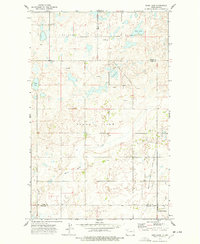 1974 Bush Lake1978 Print · USGSNorthwestern North Dakota's prairie landscape is shown during the mid-seventies energy boom. Genealogists and local historians can trace rural landmarks like Our Saviors Ch, the local Town Hall, and the expanding Stoneview Oil and Gas Field.
End of results
Showing maps 1-3 of 3
Top cities of Divide County
Frequently asked questions
- What are the different types of historical maps available for Divide County?
- What is the oldest map of Divide County?
- Where can I purchase historical maps of Divide County for my home or office?
- Where can I download high-res historical maps of Divide County?
- Are there historical topographic maps available for Divide County?
- Is there historical aerial imagery available for Divide County?
- Where are historical maps of Divide County sourced from?