1950s Maps of Divide County, North Dakota
Explore 7 historic maps of Divide County from the 1950s. These maps offer a rare glimpse into what life looked like during the 1950s — showing old roads, neighborhoods, homes, and landmarks that have changed or disappeared over time.
Whether you're researching your family's past, planning a metal detecting trip, or studying how Divide County's landscape evolved across the 1950s, these high-resolution maps are a powerful tool for exploring the history of this region.
- Focus on a specific era: All maps on this page are from the 1950s, giving you a focused view of this time period.
- See what’s changed: Compare century-old streets, trails, and buildings to today's modern landscape using overlays and satellite layers.
- Research with precision: Use these maps for genealogy, historical research, land use analysis, or educational projects.
- View, download, or print: Maps are fully viewable online in high resolution, and can be downloaded or printed for your own records.
Start exploring Divide County's history through authentic maps from the 1950s. This is your window into the past.
Divide County, ND maps
(7)- 1950 Map of Crosby
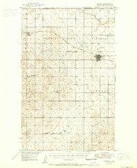 1950 Crosby1950 Print · USGSDivide County sits at the intersection of the Canadian and Montana borders in the mid-century, defined by a vast grid of prairie townships and rail lines. Genealogists can trace rural life through numerous country schools like Hawkeye Sch and Roseville Sch, or local landmarks like Ambrose Cem and the Crosby Country Club.2 unique versions available
 - 1950 Map of Columbus
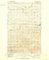
 1950 Columbus1950 Print · USGSThe Burke County borderlands at the dawn of the fifties reveal a landscape defined by international boundaries and a thriving coal industry. Local historians can trace the rail-side growth of Columbus and Kincaid, or locate rural landmarks like the Strip Mine and South St Olaf Ch.2 unique versions available
 - 1950 Map of Noonan
 1950 Noonan1950 Print · USGSThe North Dakota borderlands come alive in the mid-century, showing a landscape defined by the Great Northern railroad and rural townships. Genealogists can trace family roots through a dense network of schoolhouses and country churches like Zion Ch and Long Creek Ch.2 unique versions available
 - 1953 Map of Williston, 1968 Print
 1953 Williston1968 Print · USGSThe North Dakota high plains meet the waters of Sakakawea Lake in this mid-century survey of the northern borderlands. Trace the rail-and-ranch economy through sites like Anderson Sky Ranch, Sevenmile Corner, and the strip mines near Columbus.2 unique versions available
 - 1954 Map of Wolf Point, 1967 Print
 1954 Wolf Point1967 Print · USGSNortheastern Montana and the North Dakota borderlands are shown here in the mid-fifties, dominated by the Missouri River and the Fort Peck Indian Reservation. Genealogists and historians can trace the Great Northern rail line through river towns like Poplar and Culbertson or locate northern border outposts like the U S Custom Office at Raymond.2 unique versions available
 - 1957 Map of Williston
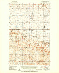
 1957 Williston1957 Print · USGSNorthwestern North Dakota is shown here during the mid-fifties, dominated by the sweeping plains and the Missouri River valley. Genealogists and local historians can trace the paths of the Great Northern railroad through Williston, Tioga, and Ray, or locate early industry like the coal strip mines near Lignite.
 - 1958 Map of Wolf Point
 1958 Wolf Point1958 Print · USGSNortheastern Montana is shown during the mid-fifties, featuring the extensive Fort Peck Indian Reservation and the Missouri River valley. Researchers can trace the Great Northern railroad through Wolf Point or locate sites like Slab Crossing and the Coal Mine near Medicine Lake.
End of results
Showing maps 1-7 of 7
Top cities of Divide County
Frequently asked questions
- What are the different types of historical maps available for Divide County?
- What is the oldest map of Divide County?
- Where can I purchase historical maps of Divide County for my home or office?
- Where can I download high-res historical maps of Divide County?
- Are there historical topographic maps available for Divide County?
- Is there historical aerial imagery available for Divide County?
- Where are historical maps of Divide County sourced from?