1990s Maps of Dunn County, North Dakota
Explore 6 historic maps of Dunn County from the 1990s. These maps offer a rare glimpse into what life looked like during the 1990s — showing old roads, neighborhoods, homes, and landmarks that have changed or disappeared over time.
Whether you're researching your family's past, planning a metal detecting trip, or studying how Dunn County's landscape evolved across the 1990s, these high-resolution maps are a powerful tool for exploring the history of this region.
- Focus on a specific era: All maps on this page are from the 1990s, giving you a focused view of this time period.
- See what’s changed: Compare century-old streets, trails, and buildings to today's modern landscape using overlays and satellite layers.
- Research with precision: Use these maps for genealogy, historical research, land use analysis, or educational projects.
- View, download, or print: Maps are fully viewable online in high resolution, and can be downloaded or printed for your own records.
Start exploring Dunn County's history through authentic maps from the 1990s. This is your window into the past.
Dunn County, ND maps
(6)- 1997 Map of Grassy Butte SE, 2001 Print
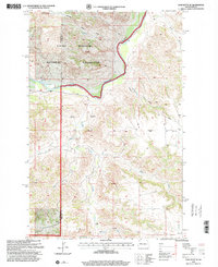
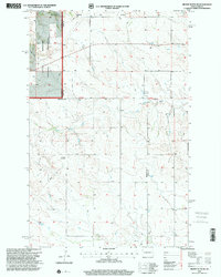 1997 Grassy Butte SE2001 Print · USGSDunn County and the surrounding badlands are shown during the late 1990s as the energy industry and grazing lands converged. Genealogists and historians can trace local heritage through sites like the Greek Ch, a Russian Cem, and the Little Knife Gas Plant.
 - 1997 Map of Figure 4 Ranch, 2001 Print
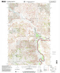
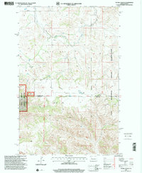 1997 Figure 4 Ranch2001 Print · USGSThe McKenzie and Dunn County line area in the late nineties is captured here during a period of modern ranching and land management. Researchers can trace the sprawling bounds of the Figure 4 Ranch and the eastern edge of the Little Missouri National Grassland.
 - 1997 Map of Petes Creek, 2001 Print
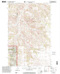 1997 Petes Creek2001 Print · USGSDunn and McKenzie counties show a landscape of high divides and deep coulees during the late nineties. Explore the terrain around Killdeer Mountain, trace the operations of the Knife Oil Field, and locate a remote Grave in the rugged prairie.
 - 1997 Map of Croff, 2001 Print
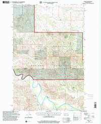 1997 Croff2001 Print · USGSMcKenzie County ranching and the winding river bottom are captured here in the late twentieth century. Researchers can trace historic homestead signatures like Fenton Ranch and Croff Sch along the banks of the Little Missouri River.
 - 1997 Map of Lone Butte SE, 2001 Print
 1997 Lone Butte SE2001 Print · USGSThe North Dakota Badlands in the late nineties are defined by the winding Little Missouri River and its surrounding federal grasslands. Genealogists and researchers can locate the Quilliam Sch and trace the early development of the Lone Butte Oil Field.
 - 1997 Map of Lone Butte NE, 2001 Print
 1997 Lone Butte NE2001 Print · USGSWestern North Dakota's badlands and ranching country are frozen in time here during the late twentieth century. Researchers can trace historic property boundaries and water rights at the Trails End Ranch, Olson Ranch, and along the Little Missouri River.
End of results
Showing maps 1-6 of 6
Top cities of Dunn County
- Killdeer historical maps
- Halliday historical maps
- Dodge historical maps
- Dunn Center historical maps
- Manning historical maps
Frequently asked questions
- What are the different types of historical maps available for Dunn County?
- What is the oldest map of Dunn County?
- Where can I purchase historical maps of Dunn County for my home or office?
- Where can I download high-res historical maps of Dunn County?
- Are there historical topographic maps available for Dunn County?
- Is there historical aerial imagery available for Dunn County?
- Where are historical maps of Dunn County sourced from?