1930s Maps of Grand Forks County, North Dakota
Explore 7 historic maps of Grand Forks County from the 1930s. These maps offer a rare glimpse into what life looked like during the 1930s — showing old roads, neighborhoods, homes, and landmarks that have changed or disappeared over time.
Whether you're researching your family's past, planning a metal detecting trip, or studying how Grand Forks County's landscape evolved across the 1930s, these high-resolution maps are a powerful tool for exploring the history of this region.
- Focus on a specific era: All maps on this page are from the 1930s, giving you a focused view of this time period.
- See what’s changed: Compare century-old streets, trails, and buildings to today's modern landscape using overlays and satellite layers.
- Research with precision: Use these maps for genealogy, historical research, land use analysis, or educational projects.
- View, download, or print: Maps are fully viewable online in high resolution, and can be downloaded or printed for your own records.
Start exploring Grand Forks County's history through authentic maps from the 1930s. This is your window into the past.
Grand Forks County, ND maps
(7)- 1934 Map of Emerado
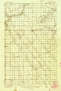 1934 Emerado1934 Print · USGSThe Red River Valley prairie is captured here in the mid-1930s, showing a landscape of strictly gridded farmsteads and rural townships. Genealogists can trace family connections through numerous local landmarks like Mc Cray Sch, Blooming Town Hall, and the Washington Ch.4 unique versions available
 - 1934 Map of Grand Forks
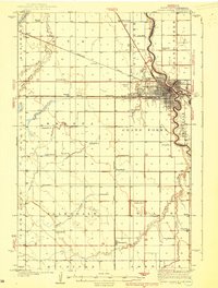
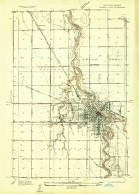 1934 Grand Forks1934 Print · USGSGrand Forks and East Grand Forks appear as a burgeoning rail and river hub in the mid-1930s. Researchers can trace the early footprint of the University of North Dakota or locate local landmarks like the State Elevator and Mill and Schumeier Switch.
 - 1934 Map of Grand Forks
 1934 Grand Forks1934 Print · USGSThe Red River Valley in the mid-1930s shows a landscape of growing river towns and a dense network of rural school districts. Genealogists can trace family connections to the UNIVERSITY OF NORTH DAKOTA, West Walle Ch, or early outposts like Merrifield and Schurmeier.2 unique versions available
 - 1936 Map of Emerado
 1936 Emerado1936 Print · USGSGrand Forks County agriculture thrived in the mid-1930s as the railroad and new highways bridged the prairie. Genealogists can locate family-named landmarks and rural hubs like the Blooming Town Hall, Gilbert Sch, and Emerado Evangelical Ch.3 unique versions available
 - 1936 Map of Larimore
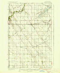
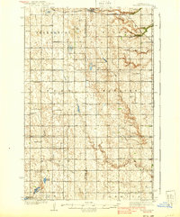
 1936 Larimore1936 Print · USGSGrand Forks County agriculture and transit are in full focus during the mid-1930s as the Great Northern railroad connects prairie towns. Genealogists can trace early landmarks like United Lutheran Church & Cem, Shawnee, and over a dozen numbered schools including School No 36.3 unique versions available
 - 1938 Map of Grand Forks
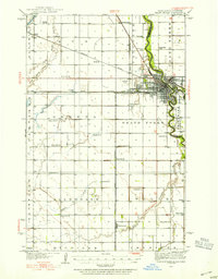
 1938 Grand Forks1938 Print · USGSGrand Forks and East Grand Forks appear as thriving rail hubs in the mid-1930s at the confluence of the Red and Red Lake Rivers. Researchers can trace rural school locations from School No 25 to School No 6 and identify landmarks like the Landing Field and Brenna Ch.3 unique versions available
 - 1939 Map of Niagara
 1939 Niagara1939 Print · USGSThe northern prairie along the Nelson and Grand Forks county line is shown here in the mid-1930s, defined by its glacial terrain and rail-fed towns. Trace the locations of early rural schools and congregations like Lunney Sch, Logan Ch, and Bethel Ch.2 unique versions available
End of results
Showing maps 1-7 of 7
Top cities of Grand Forks County
- Grand Forks historical maps
- Mekinock historical maps
- Larimore historical maps
- Thompson historical maps
- Northwood historical maps
- Emerado historical maps
See more
Frequently asked questions
- What are the different types of historical maps available for Grand Forks County?
- What is the oldest map of Grand Forks County?
- Where can I purchase historical maps of Grand Forks County for my home or office?
- Where can I download high-res historical maps of Grand Forks County?
- Are there historical topographic maps available for Grand Forks County?
- Is there historical aerial imagery available for Grand Forks County?
- Where are historical maps of Grand Forks County sourced from?