1960s Maps of McKenzie County, North Dakota
Explore 19 historic maps of McKenzie County from the 1960s. These maps offer a rare glimpse into what life looked like during the 1960s — showing old roads, neighborhoods, homes, and landmarks that have changed or disappeared over time.
Whether you're researching your family's past, planning a metal detecting trip, or studying how McKenzie County's landscape evolved across the 1960s, these high-resolution maps are a powerful tool for exploring the history of this region.
- Focus on a specific era: All maps on this page are from the 1960s, giving you a focused view of this time period.
- See what’s changed: Compare century-old streets, trails, and buildings to today's modern landscape using overlays and satellite layers.
- Research with precision: Use these maps for genealogy, historical research, land use analysis, or educational projects.
- View, download, or print: Maps are fully viewable online in high resolution, and can be downloaded or printed for your own records.
Start exploring McKenzie County's history through authentic maps from the 1960s. This is your window into the past.
McKenzie County, ND maps
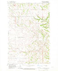
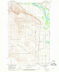
(19)- 1965 Map of Keene, 1966 Print
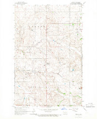 1965 Keene1966 Print · USGSMcKenzie County ranching country comes into focus in the mid-1960s, showing the isolated community of Keene and its surrounding prairie. Researchers can trace rural life through the Hawkeye Sch, the Adventist Ch, and landmarks like Blue Butte.
 - 1965 Map of Johnsons Corner, 1966 Print
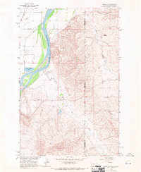
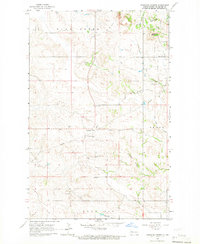 1965 Johnsons Corner1966 Print · USGSMcKenzie County's high plains are documented here in the mid-1960s as the regional energy economy began to shape the landscape. Researchers can trace local lineage at Silent City Cem or Union Cem and locate industrial landmarks like the Blue Butte Oil and Gas Field.
 - 1965 Map of Charlson, 1966 Print
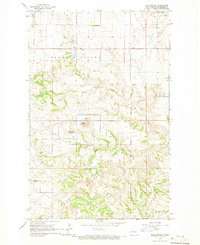
 1965 Charlson1966 Print · USGSMcKenzie County in the mid-1960s reveals a prairie landscape transitioning into an industrial energy hub. Genealogists and historians can locate the Charlson settlement, remote burial sites like Riverside Cem, and the extensive Oil and Gas Field.
 - 1965 Map of Blue Buttes, 1966 Print
 1965 Blue Buttes1966 Print · USGSMcKenzie County was a landscape of remote ranchlands and emerging energy extraction in the mid-sixties. Genealogists and historians can locate rural landmarks like Redeemer Cem, Reservation Sch, and the high peaks of Chimney Butte.
 - 1965 Map of Charlson SW, 1967 Print
 1965 Charlson SW1967 Print · USGSMcKenzie County was undergoing an industrial transformation in the mid-1960s as petroleum extraction expanded across the Missouri River breaks. Genealogists and historians can locate the Good Hope Ch and trace the early development of the Charlson Oil Field and Hawkeye Valley Oil Field.
 - 1965 Map of Charlson NE, 1967 Print
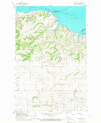
 1965 Charlson NE1967 Print · USGSMountrail and Williams Counties meet at the edge of the Garrison Reservoir during the mid-sixties. Researchers can trace the original path of the Missouri River and explore terrain features like Dry Fork and Elm Tree.
 - 1965 Map of Blue Buttes SE, 1967 Print
 1965 Blue Buttes SE1967 Print · USGSMcKenzie County was a landscape of remote ranching and reservation lands in the mid-1960s. Genealogists and researchers can trace the Fort Berthold Indian Reservation Boundary and find local landmarks like the Scoria Pit and Aura Butte.
 - 1965 Map of Charlson NW, 1967 Print
 1965 Charlson NW1967 Print · USGSThe mid-sixties transformation of the Missouri River valley is clear in this survey of the Garrison Reservoir shoreline. Researchers can trace industrial markers like the Hofflund Gas and Oil Field alongside local landmarks such as Farmvale and the Scoria Pits.
 - 1966 Map of Sidney NE, 1970 Print
 1966 Sidney NE1970 Print · USGSThe Montana and North Dakota border comes alive in the mid-1960s as the Yellowstone River carves through the high plains. Researchers can trace the Great Northern rail line or locate industrial markers like the Thief Mine and McGlynn Dam.2 unique versions available
 - 1967 Map of Watford City
 1967 Watford City1967 Print · USGSWestern North Dakota is captured during a period of landscape transformation as the Missouri River valley was reshaped by the new Garrison Reservoir. Genealogists and local historians can trace the foundations of Watford City, find the Elkhorn Ranch Site, or locate rural landmarks like Ziner Butte and Grassy Butte.
 - 1967 Map of Sanish NW, 1969 Print
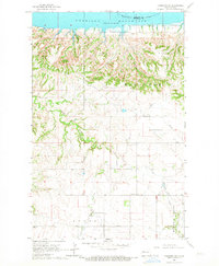
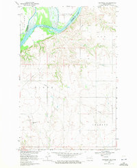
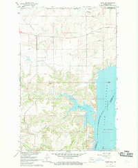 1967 Sanish NW1969 Print · USGSThe Fort Berthold Indian Reservation and the Missouri River highlight this North Dakota landscape in the late sixties as the water levels rose. Genealogists and local researchers can locate the Snowbird Chapel, Goodbird Cem, and the sprawling Antelope Oil Field.
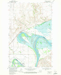
 - 1967 Map of Sanish, 1969 Print
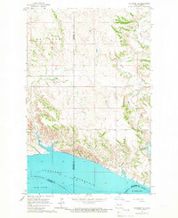
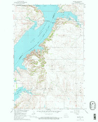 1967 Sanish1969 Print · USGSThe Missouri River valley in the late sixties reveals a landscape transformed by the waters of Lake Sakakawea along the Fort Berthold Indian Reservation boundary. Genealogists and local historians can trace the foundations of Sanish, locate the Riverview Cemetery, and follow the path of an Old Railroad Grade.2 unique versions available
 - 1967 Map of Sanish SW, 1970 Print
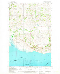
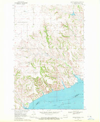
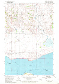
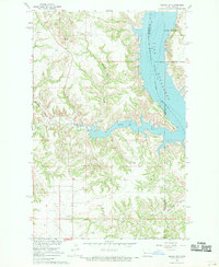 1967 Sanish SW1970 Print · USGSMcKenzie County's badlands terrain meets the rising waters of the Missouri River in the late sixties. Trace the inundated shoreline of Lake Sakakawea and find landmarks like Blue Butte or the Bear Den Creek Public Use Area.
 - 1968 Map of Buford, 1971 Print
 1968 Buford1971 Print · USGSThe confluence of the Missouri and Yellowstone rivers is documented here in the late sixties, just as the landscape was being reshaped by the rising waters of Lake Sakakawea. Researchers can trace the grounds of Fort Buford State Historic Site and the Burlington Northern rail line near the settlement of Buford.2 unique versions available
 - 1968 Map of Dore, 1971 Print
 1968 Dore1971 Print · USGSThe Montana-North Dakota borderlands in the late sixties come alive through this survey of the Missouri River confluence. Genealogists and historians can trace the small rail stops of Dore and Nohly alongside the Fort Buford State Historic Site.2 unique versions available
 - 1969 Map of Trenton, 1971 Print
 1969 Trenton1971 Print · USGSThe Missouri River valley near the Montana border comes into focus in this late-sixties study of the North Dakota landscape. Researchers can trace the Burlington Northern rail line through Trenton or locate landmarks like the Crow Fly High Hills and the Lake Trenton Pumping Sta.2 unique versions available
 - 1969 Map of Cartwright NE, 1971 Print
 1969 Cartwright NE1971 Print · USGSThe Missouri River breaks through the high plains of McKenzie County in the late sixties, just as Lake Sakakawea reached its modern pool elevation. Researchers can locate the Yellowstone Point Cem and trace infrastructure through Elk and Charbon.
 - 1969 Map of Cussicks Spring, 1972 Print
 1969 Cussicks Spring1972 Print · USGSThe Missouri River breaks into the flooded expanse of Lake Sakakawea during the late 1960s, revealing a landscape shaped by water management and rural life. Genealogists and historians can locate the Wunderlich Sch, family-named springs like Mark Adams Spring, and the shoreline at Lunds Landing.
 - 1969 Map of Red Mike Hill, 1972 Print
 1969 Red Mike Hill1972 Print · USGSNorth Dakota's Missouri River breaks are captured here in the late sixties as the landscape adjusted to the rising waters of the reservoir. Researchers can pinpoint rural community hubs like Beaver Creek Ch and trace the contours of Red Mike Hill or the Nesson Valley.2 unique versions available
End of results
Showing maps 1-19 of 19
Top cities of McKenzie County
- Watford City historical maps
- Arnegard historical maps
- Alexander historical maps
- Hawkeye historical maps
- Keene historical maps
Frequently asked questions
- What are the different types of historical maps available for McKenzie County?
- What is the oldest map of McKenzie County?
- Where can I purchase historical maps of McKenzie County for my home or office?
- Where can I download high-res historical maps of McKenzie County?
- Are there historical topographic maps available for McKenzie County?
- Is there historical aerial imagery available for McKenzie County?
- Where are historical maps of McKenzie County sourced from?