
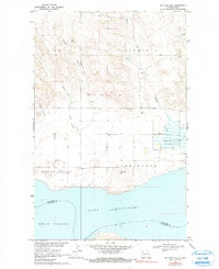
1969 Map of Red Mike Hill
USGS Topo · Published 1972About this map
Lake Sakakawea dominates the southern landscape of this 1969 North Dakota survey, where the waters of the Missouri River are managed within a complex network of coulees and high plains. The transition from the rugged Scoria Hills in the north to the broad river valley illustrates the area's geological character, marked by resource extraction sites like a Scoria Pit and a remote Mine. This era captures the rural community infrastructure of Hofflund and Farmvale before modern consolidation, preserving the locations of the Hofflund Sch and Beaver Creek Ch. Notable terrain features such as Red Mike Hill and Half Breed Coulee provide fixed landmarks for genealogists tracing family land near the Hofflund State Game Management Area and the fertile stretches of Nesson Valley.
Find a feature on this map
19 named features on this map. Tap any name to fly to it.
Don’t see what you’re looking for? This feature index may not catch every label — zoom into the map to look around manually.
Map Details
Editions of this 1969 Red Mike Hill Map
2 editions found
Other maps of this area

1911 · Ray
USGS Topo · 1:125,000

1953 · Williston
USGS Topo · 1:250,000

1957 · Williston
USGS Topo · 1:250,000

1965 · Charlson SW
USGS Topo · 1:24,000

1965 · Charlson NW
USGS Topo · 1:24,000

1969 · Cussicks Spring
USGS Topo · 1:24,000

1978 · Ray
USGS Topo · 1:24,000

1978 · Tobacco Garden Bay
USGS Topo · 1:24,000

1978 · Ray SE
USGS Topo · 1:24,000
1978 · Banks
USGS Topo · 1:24,000