1960s Maps of Richland County, North Dakota
Explore 26 historic maps of Richland County from the 1960s. These maps offer a rare glimpse into what life looked like during the 1960s — showing old roads, neighborhoods, homes, and landmarks that have changed or disappeared over time.
Whether you're researching your family's past, planning a metal detecting trip, or studying how Richland County's landscape evolved across the 1960s, these high-resolution maps are a powerful tool for exploring the history of this region.
- Focus on a specific era: All maps on this page are from the 1960s, giving you a focused view of this time period.
- See what’s changed: Compare century-old streets, trails, and buildings to today's modern landscape using overlays and satellite layers.
- Research with precision: Use these maps for genealogy, historical research, land use analysis, or educational projects.
- View, download, or print: Maps are fully viewable online in high resolution, and can be downloaded or printed for your own records.
Start exploring Richland County's history through authentic maps from the 1960s. This is your window into the past.
Richland County, ND maps
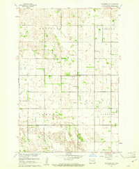
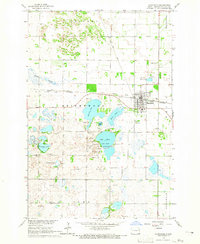
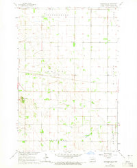
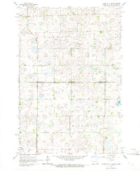
(26)- 1960 Map of Galchutt, 1961 Print
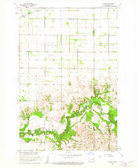
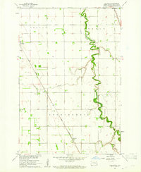 1960 Galchutt1961 Print · USGSRichland County, North Dakota, is captured here in the early sixties as a settled landscape of rail-side hamlets and meandering prairie rivers. Genealogists and historians can locate rural landmarks like Bethany Ch and trace the paths of the Great Northern and C M St P & P railroads.
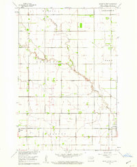
 - 1960 Map of Wyndmere, 1961 Print
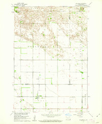
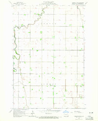
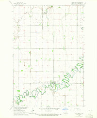
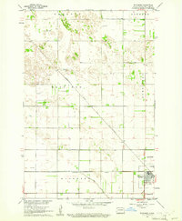 1960 Wyndmere1961 Print · USGSRichland County at the start of the sixties reveals a thriving rail hub where the Northern Pacific meets the Soo Line. Genealogists and historians can trace the rural landscape of Homestead and Danton or locate the local Drive-in Theater.
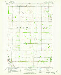
 - 1960 Map of Power, 1961 Print
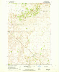
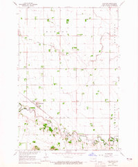
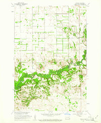 1960 Power1961 Print · USGSThe rural prairie of Richland County is captured here in the early sixties as the Sheyenne River winds through a network of established townships. Researchers can trace the mid-century footprints of the Power settlement, several country churches like Zion Ch, and the local Town Hall.
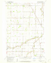
 - 1960 Map of Barrie, 1961 Print
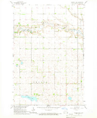
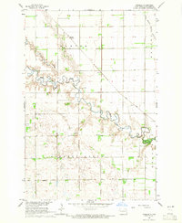
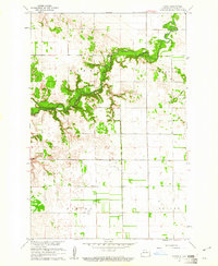 1960 Barrie1961 Print · USGSRichland County, North Dakota, is documented here at the start of the sixties as the prairie townships remained deeply tied to the land. Genealogists and local historians can trace the Sheyenne River valley to find Gol Ch, Gol Cem, and the old School No 3.
 - 1960 Map of Wyndmere NW, 1961 Print
 1960 Wyndmere NW1961 Print · USGSRichland County's rural townships are preserved here during the mid-century, documenting a landscape of family farms and small country schools. Researchers can trace local heritage through landmarks like Nordmanna Cem, United Lutheran Ch, and School No 2.
 - 1960 Map of Mooreton West, 1961 Print
 1960 Mooreton West1961 Print · USGSRichland County at the start of the 1960s shows a landscape of precise township grids and prairie waterways. Genealogists and local researchers can trace the rail corridor of the Northern Pacific and locate rural landmarks like Antelope Sch and Antelope Cem.2 unique versions available
 - 1960 Map of Wyndmere SE, 1961 Print
 1960 Wyndmere SE1961 Print · USGSRichland County at the start of the 1960s reveals a landscape shaped by competing rail lines and organized agriculture. Genealogists can trace family roots through markers at St John Cem or locate community centers like Homestead Ch and the village of Barney.
 - 1960 Map of Mooreton East, 1961 Print
 1960 Mooreton East1961 Print · USGSRichland County's agricultural heartland is captured here during the mid-twentieth century, showing a landscape defined by rail lines and section roads. Genealogists and local historians can trace the foundations of Mooreton and Farmington or locate rural landmarks like St Paul Ch and Wahpeton School No 5.2 unique versions available
 - 1960 Map of Coburn, 1962 Print
 1960 Coburn1962 Print · USGSRansom County's prairie and river-valley landscape are captured here during the early sixties, showing the agricultural patterns of the Great Plains. Researchers can locate family landmarks like the Owego Ch, the Northern Pacific rail line, and the Vivasaker Bridge crossing.
 - 1960 Map of De Lamere, 1962 Print
 1960 De Lamere1962 Print · USGSThe North Dakota prairie near De Lamere is captured here during the early 1960s as a thriving rail-and-well agricultural hub. Genealogists can locate specific landmarks like the Anderson Cem, School No 1, and the many Flowing Wells that sustained these rural townships.
 - 1961 Map of Sheldon NE, 1963 Print
 1961 Sheldon NE1963 Print · USGSSoutheast North Dakota’s prairie landscape was shaped by the winding Maple River and the transit lines of the early 1960s. Researchers can trace the legacy of pioneer settlements through the Northern Pacific rail line and family-history sites like Watson Cem and Leonard Cem.
 - 1961 Map of McLeod, 1964 Print
 1961 McLeod1964 Print · USGSThe eastern North Dakota prairie is captured here in the early sixties, centered on the railroad hub of McLeod. Researchers can trace the path of the Soo Line and locate the Free Lutheran Cem near the borders of Sheyenne and Owego.
 - 1964 Map of Kreiser Lake, 1965 Print
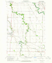
 1964 Kreiser Lake1965 Print · USGSRichland County's prairie landscape and winding waterways are captured here in the mid-1960s. Researchers can trace rural cemetery locations like Elk Creek Cem or study the hydrology of the Wild Rice River and Kreiser Lake.
 - 1964 Map of Hankinson, 1965 Print
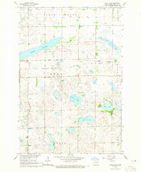
 1964 Hankinson1965 Print · USGSHankinson served as a busy North Dakota rail junction in the mid-sixties, where the prairie landscape is dotted with numerous glacial lakes. Researchers can trace the Great Northern Old Railroad Grade, find family sites at Hillside Cem, or locate the rural School No 2.
 - 1964 Map of Fairmount NW, 1965 Print
 1964 Fairmount NW1965 Print · USGSRichland County's agricultural heartland is captured in the mid-1960s, showing the rural organization of Center and Summit. Genealogists and local historians can locate specific farmsteads near St Johns Ch and trace the paths to School No 1 or the local Townhall.
 - 1964 Map of Mantador, 1965 Print
 1964 Mantador1965 Print · USGSRichland County's agricultural heartland is documented here in the mid-1960s, showing the intersection of rail and river life. Researchers can trace family roots through Mantador and Bayne, or locate historical sites like St Johns Ch and Calvary Cem.
 - 1964 Map of Moselle, 1965 Print
 1964 Moselle1965 Print · USGSRichland County, North Dakota, is captured here in the mid-1960s as a landscape of rural townships and winding river valleys. You can trace the Soo Line rail corridor through Moselle or locate local landmarks like Nulph Cem and School No 1.
 - 1964 Map of Hankinson SE, 1965 Print
 1964 Hankinson SE1965 Print · USGSRichland County at the start of the 1960s reveals a structured agricultural landscape shaped by the rail lines of the prairie. Genealogists and historians can trace old property lines across Brandenburg or locate rural landmarks like School No 1 and the Soo Line.
 - 1964 Map of Great Bend, 1965 Print
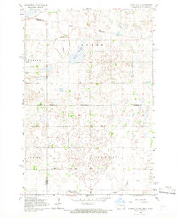
 1964 Great Bend1965 Print · USGSRichland County agriculture and river life are captured here in the mid-1960s, centered on the tight meanders of the Wild Rice River. Researchers can trace the Northern Pacific rail corridor and locate family sites near Great Bend or Trinity Cem.2 unique versions available
 - 1964 Map of Lidgerwood, 1965 Print
 1964 Lidgerwood1965 Print · USGSLidgerwood and the surrounding Richland County prairie are documented here in the mid-1960s at a time of transitioning rail commerce. You can trace the Great Northern Line and an Old Railroad Grade, or locate family sites near the Bohemian Cem and St Johns Cem.
 - 1964 Map of Swan Lake, 1965 Print
 1964 Swan Lake1965 Print · USGSRichland County's prairie wetland character is captured in the mid-sixties, showing a landscape defined by glacial sloughs and transitioning rail lines. Researchers can trace the path of the Soo Line Great Northern Railroad Grade and locate Stiles or the Emmanuel Ch.
 - 1964 Map of Claire City NE, 1966 Print
 1964 Claire City NE1966 Print · USGSRichland and Roberts counties meet along the Dakotas' border in the mid-1960s, a landscape defined by prairie wetlands and small rural parishes. Genealogists can locate family landmarks like St Pauls Cem, Ferkingstad Ch, and School No 2.
 - 1964 Map of Dwight, 1966 Print
 1964 Dwight1966 Print · USGSThe Red River Valley landscape in the mid-1960s highlights the agricultural and spiritual roots of the North Dakota borderlands. Researchers can trace family history at St Josephs Cemetery or locate local landmarks like the Carmelite Monastery and Brushvale.3 unique versions available
 - 1964 Map of Claire City NW, 1966 Print
 1964 Claire City NW1966 Print · USGSCrossing the North Dakota-South Dakota border in the mid-1960s, this area shows the intersection of the Sisseton Indian Reservation and various county lines. Genealogists can locate family landmarks like Bergen Ch Cem and the Nidaros Ch among the prairie sloughs.
 - 1964 Map of Wahpeton, 1966 Print
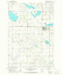
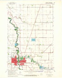 1964 Wahpeton1966 Print · USGSThe Red River valley thrived as a vital rail and educational hub in the mid-sixties, where North Dakota and Minnesota met at the water's edge. Genealogists and researchers can trace the Wahpeton Indian Sch, the St Marys Cem, and several historic Great Northern rail lines.3 unique versions available
Showing maps 1-25 of 26
Top cities of Richland County
- Wahpeton historical maps
- Hankinson historical maps
- Lidgerwood historical maps
- Wyndmere historical maps
- Fairmount historical maps
- Abercrombie historical maps
See more
Frequently asked questions
- What are the different types of historical maps available for Richland County?
- What is the oldest map of Richland County?
- Where can I purchase historical maps of Richland County for my home or office?
- Where can I download high-res historical maps of Richland County?
- Are there historical topographic maps available for Richland County?
- Is there historical aerial imagery available for Richland County?
- Where are historical maps of Richland County sourced from?