1970s Maps of Richland County, North Dakota
Explore 9 historic maps of Richland County from the 1970s. These maps offer a rare glimpse into what life looked like during the 1970s — showing old roads, neighborhoods, homes, and landmarks that have changed or disappeared over time.
Whether you're researching your family's past, planning a metal detecting trip, or studying how Richland County's landscape evolved across the 1970s, these high-resolution maps are a powerful tool for exploring the history of this region.
- Focus on a specific era: All maps on this page are from the 1970s, giving you a focused view of this time period.
- See what’s changed: Compare century-old streets, trails, and buildings to today's modern landscape using overlays and satellite layers.
- Research with precision: Use these maps for genealogy, historical research, land use analysis, or educational projects.
- View, download, or print: Maps are fully viewable online in high resolution, and can be downloaded or printed for your own records.
Start exploring Richland County's history through authentic maps from the 1970s. This is your window into the past.
Richland County, ND maps
(9)- 1972 Map of La Mars, 1973 Print
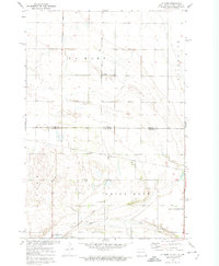 1972 La Mars1973 Print · USGSThe Dakota borderlands come into focus in the early seventies, centered on the rural township of La Mars. Genealogists and local historians can trace the Sisseton Indian Reservation Boundary, Bethany Ch, and the many sections of White Rock.
 - 1972 Map of New Effington NE, 1974 Print
 1972 New Effington NE1974 Print · USGSThe North Dakota and South Dakota borderlands are captured here in the early 1970s, split between the plains of Greendale and Victor. Researchers can locate rural landmarks like Old Brandvold Cem and the Soo Line rail corridor.
 - 1972 Map of New Effington NW, 1974 Print
 1972 New Effington NW1974 Print · USGSThe North Dakota and South Dakota borderlands were a patchwork of conservation and homesteads in the early seventies. Trace family sites at Bohemian Cem or Thompson Cem and explore the bounds of the Sisseton Indian Reservation Boundary.
 - 1972 Map of Boisberg, 1974 Print
 1972 Boisberg1974 Print · USGSThe tri-state borderlands of Minnesota and the Dakotas come alive in the early seventies, centered on the Bois De Sioux River. Researchers can trace old rail siding communities like White Rock and Boisberg or locate family plots at Lake View Cem.
 - 1972 Map of Sonora, 1975 Print
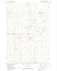
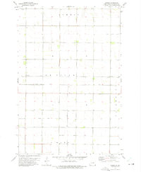 1972 Sonora1975 Print · USGSRichland County at the start of the seventies shows a highly organized agricultural landscape shaped by its drainage systems and rail lines. Genealogists and local historians can trace the Soo Line corridor between Oswald and De Villo, or locate St Josephs Cem in the north.
 - 1973 Map of Abercrombie, 1975 Print
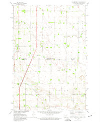
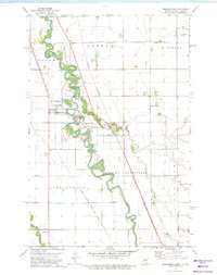 1973 Abercrombie1975 Print · USGSThe Red River valley in the early 1970s shows a landscape defined by sharp river bends and competing rail lines. Genealogists can locate St Johns Ch and St Thomas Cem, or explore the grounds of Fort Abercrombie State Park.
 - 1973 Map of South of Wahpeton, 1975 Print
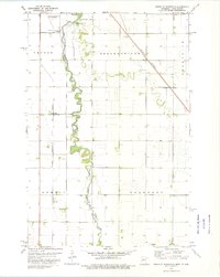 1973 South of Wahpeton1975 Print · USGSWilkin County and the North Dakota border come into focus in the early seventies along the winding Bois De Sioux River. Genealogists and local historians can trace family locations near the Bohemian National Cem or the rail stop at Tyler.
 - 1973 Map of Fairmount, 1975 Print
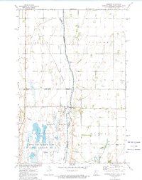
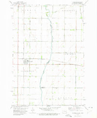 1973 Fairmount1975 Print · USGSFairmount and the surrounding prairie of the Red River Valley are seen here in the early seventies as a vital rail hub on the North Dakota-Minnesota border. Researchers can trace the paths of the Soo Line, locate the Fairmount Cem, and explore old rural sites like Childs.
 - 1979 Map of Sisseton, 1980 Print
 1979 Sisseton1980 Print · USGSNortheastern South Dakota and the North Dakota borderlands appear here in the late seventies, centered on the high glacial plateau. Genealogists and historians can trace the Sisseton Indian Reservation and rail-stop towns like Britton and Lake City.
End of results
Showing maps 1-9 of 9
Top cities of Richland County
- Wahpeton historical maps
- Hankinson historical maps
- Lidgerwood historical maps
- Wyndmere historical maps
- Fairmount historical maps
- Abercrombie historical maps
See more
Frequently asked questions
- What are the different types of historical maps available for Richland County?
- What is the oldest map of Richland County?
- Where can I purchase historical maps of Richland County for my home or office?
- Where can I download high-res historical maps of Richland County?
- Are there historical topographic maps available for Richland County?
- Is there historical aerial imagery available for Richland County?
- Where are historical maps of Richland County sourced from?