1990s Maps of Stark County, North Dakota
Explore 4 historic maps of Stark County from the 1990s. These maps offer a rare glimpse into what life looked like during the 1990s — showing old roads, neighborhoods, homes, and landmarks that have changed or disappeared over time.
Whether you're researching your family's past, planning a metal detecting trip, or studying how Stark County's landscape evolved across the 1990s, these high-resolution maps are a powerful tool for exploring the history of this region.
- Focus on a specific era: All maps on this page are from the 1990s, giving you a focused view of this time period.
- See what’s changed: Compare century-old streets, trails, and buildings to today's modern landscape using overlays and satellite layers.
- Research with precision: Use these maps for genealogy, historical research, land use analysis, or educational projects.
- View, download, or print: Maps are fully viewable online in high resolution, and can be downloaded or printed for your own records.
Start exploring Stark County's history through authentic maps from the 1990s. This is your window into the past.
Stark County, ND maps
(4)- 1997 Map of Belfield SW, 2001 Print
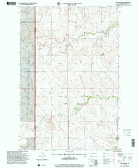 1997 Belfield SW2001 Print · USGSStark County ranching and mining country are documented here in the late nineties, where the Little Missouri National Grassland meets the Heart River. Researchers can locate rural landmarks like Belfield Sch No 1, Dorval Sch, and numerous Scoria Pits.
 - 1997 Map of Daglum NW, 2001 Print
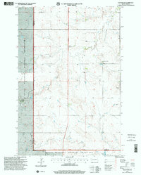 1997 Daglum NW2001 Print · USGSWestern North Dakota ranching and prairie life are captured in the late nineties as they stood across the Stark and Billings county lines. Genealogists and historians can trace family ties at Our Lady of Lourdes Ch and its Cem, or locate old landmarks like Gaylord and Swenson Ranch.
 - 1997 Map of Belfield, 2001 Print
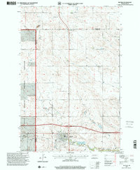 1997 Belfield2001 Print · USGSBelfield and the surrounding North Dakota plains are captured here in the late nineties at a time of continued mineral extraction and agricultural use. Researchers can locate St Stanislaus Cem, trace the course of the Heart River, and identify various Scoria Pits.
 - 1997 Map of Daglum, 2001 Print
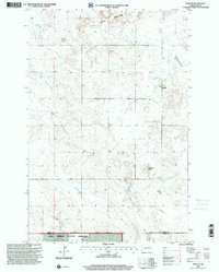 1997 Daglum2001 Print · USGSThe Stark and Slope County borderlands in the late nineties are defined here by ranching and the open plains of the Little Missouri National Grassland. Researchers can locate the Daglum Church, a nearby Cemetery, and landmarks like Flagstaff Butte.
End of results
Showing maps 1-4 of 4
Top cities of Stark County
- Dickinson historical maps
- Belfield historical maps
- Richardton historical maps
- South Heart historical maps
- Gladstone historical maps
- Taylor historical maps
Frequently asked questions
- What are the different types of historical maps available for Stark County?
- What is the oldest map of Stark County?
- Where can I purchase historical maps of Stark County for my home or office?
- Where can I download high-res historical maps of Stark County?
- Are there historical topographic maps available for Stark County?
- Is there historical aerial imagery available for Stark County?
- Where are historical maps of Stark County sourced from?