1970s Maps of Stark County, North Dakota
Explore 21 historic maps of Stark County from the 1970s. These maps offer a rare glimpse into what life looked like during the 1970s — showing old roads, neighborhoods, homes, and landmarks that have changed or disappeared over time.
Whether you're researching your family's past, planning a metal detecting trip, or studying how Stark County's landscape evolved across the 1970s, these high-resolution maps are a powerful tool for exploring the history of this region.
- Focus on a specific era: All maps on this page are from the 1970s, giving you a focused view of this time period.
- See what’s changed: Compare century-old streets, trails, and buildings to today's modern landscape using overlays and satellite layers.
- Research with precision: Use these maps for genealogy, historical research, land use analysis, or educational projects.
- View, download, or print: Maps are fully viewable online in high resolution, and can be downloaded or printed for your own records.
Start exploring Stark County's history through authentic maps from the 1970s. This is your window into the past.
Stark County, ND maps
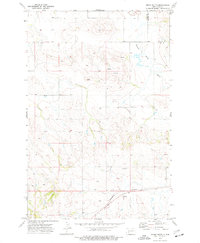
(21)- 1973 Map of Bratburg Butte
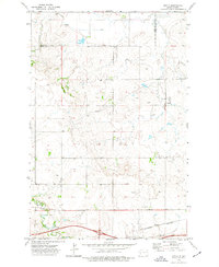
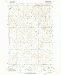
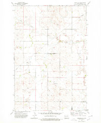
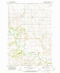 1973 Bratburg Butte1973 Print · USGSStark County in the early 1970s shows a landscape of winding river valleys and open ranch land. Researchers can trace the meandering Heart River, locate the isolated Pioneer Cemetery, and find the aviation outpost at Brands Airport.
 - 1973 Map of Hebron SE, 1977 Print
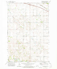
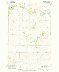
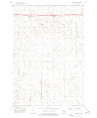 1973 Hebron SE1977 Print · USGSThe prairie landscape along the Morton and Stark county line is captured here in the early seventies, just as modern infrastructure began to cross the rural plains. You can trace the path of Heart Butte Creek, locate the Schmidt landmark, and see the early alignment of 94 near a local Gravel Pit.
 - 1973 Map of Marshall SE, 1977 Print
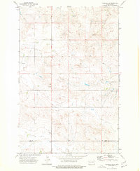 1973 Marshall SE1977 Print · USGSThe North Dakota high plains of the early seventies are documented here at the boundary of two counties. Researchers can locate agricultural landmarks like Storage Bins and trace the vital water sources identified by several Spring and Well sites across the terrain.
 - 1973 Map of Hebron, 1977 Print
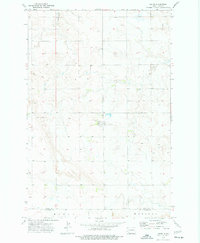
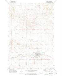 1973 Hebron1977 Print · USGSHebron and its surrounding prairies are captured in the early 1970s as the town thrived along the Burlington Northern railroad. Genealogists and researchers can locate St John Cem, St Ann Cem, and the old High School near the banks of the Knife River.
 - 1973 Map of Boyle, 1977 Print
 1973 Boyle1977 Print · USGSStark and Dunn Counties are captured in the early seventies, showing a landscape shaped by transportation and the prairie environment. Trace the infrastructure of the Burlington Northern railroad and locate water sources like the Gaging Sta along the Green River.
 - 1973 Map of Taylor, 1977 Print
 1973 Taylor1977 Print · USGSTaylor and its surrounding Stark County prairie are shown here in the early seventies as the railroad era matured. Genealogists and local historians can locate Immanuel Cem and trace the path of Beaver Cr alongside the Burlington Northern tracks.
 - 1973 Map of Willow Creek West, 1977 Print
 1973 Willow Creek West1977 Print · USGSDunn County and its neighboring borders are captured in the early 1970s, showcasing the rural water networks of the High Plains. Researchers can trace the winding Knife River and its southern Branch, or locate local landmarks like the Gravel Pit.
 - 1973 Map of Marshall SW, 1977 Print
 1973 Marshall SW1977 Print · USGSThe high plains of Dunn County come into focus during the early 1970s, showing a rural landscape anchored by isolated farmsteads and community hubs. Genealogists can locate family landmarks such as Ridgeway Ch, the local School, and the Ridgeway Community Center.
 - 1973 Map of Lefor NW, 1977 Print
 1973 Lefor NW1977 Print · USGSNorth Dakota's southern plains come to life in the 1970s, showing a land of section roads and family farms. Trace local roots through the drainage of Antelope Creek or find the community center at Christ Ch.
 - 1973 Map of New Hradec South, 1977 Print
 1973 New Hradec South1977 Print · USGSThe rural borders of Stark and Dunn counties come alive in the early 1970s, showing a landscape of traditional ranching transitioning into an era of energy extraction. Genealogists and historians can trace the vicinity of New Hradec and locate specific features like Dutch Henry Butte, North Duck Creek, and early oil infrastructure.
 - 1973 Map of Lefor, 1977 Print
 1973 Lefor1977 Print · USGSThe rural landscape of southwestern North Dakota comes into focus in the early 1970s, centered on the community of Lefor. Genealogists and local historians can trace the area's agricultural roots through features like St Elizabeth Cem, Jimmy Creek, and various local Storage Bins.
 - 1973 Map of Richardton SE, 1977 Print
 1973 Richardton SE1977 Print · USGSStark County in the early 1970s shows a landscape of wide river bends and vital transport links. Genealogists and historians can trace the Heart River valley to find a local Ford and Gravel Pits along the Burlington Northern rail line.
 - 1973 Map of Gladstone, 1977 Print
 1973 Gladstone1977 Print · USGSStark County's agricultural and transit corridors are captured here during the 1970s at the meeting of two rivers. Genealogists and historians can locate St Thomas Cem, the tracks of the Burlington Northern, and the rural community of Gladstone.
 - 1973 Map of New England NW, 1977 Print
 1973 New England NW1977 Print · USGSThe western North Dakota prairie in the early seventies shows a landscape of wide-open ranch land at the meeting of three counties. Genealogists and historians can trace the course of Antelope Creek past local landmarks like Brown and a solitary marked Grave.
 - 1973 Map of Hirschville, 1977 Print
 1973 Hirschville1977 Print · USGSDunn and Stark counties appear here in the early 1970s, showcasing a landscape of prairie draws and small-scale settlement. Researchers can locate the community of Hirschville and trace the influence of water on the land through features like Deep Creek and the Flowing Well.
 - 1973 Map of Richardton, 1977 Print
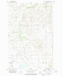
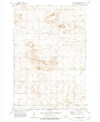
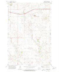
 1973 Richardton1977 Print · USGSRichardton is shown in the early 1970s as a vital rail and religious center along the Burlington Northern line. Researchers can locate significant sites including Assumption Abbey, St Marys Cem, and the waters of Abbey Lake.
 - 1973 Map of Antelope, 1977 Print
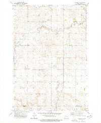
 1973 Antelope1977 Print · USGSStark County in the early 1970s shows a landscape of rail-side settlements and high-plains landmarks. You can trace the Burlington Northern tracks past Antelope or locate local high points like Young Mans Butte and Custer Lookout.
 - 1973 Map of Schefield, 1977 Print
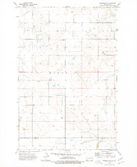
 1973 Schefield1977 Print · USGSThe borderlands of Stark and Hettinger Counties are captured here in the early seventies, showing a landscape defined by prairie agriculture. Trace local family history near Schefield through landmarks like the Cemetery, Tri State Speedway, and Antelope Creek.
 - 1973 Map of Indian Butte, 1977 Print
 1973 Indian Butte1977 Print · USGSWestern North Dakota's open plains and rising landmarks are captured here in the early 1970s as the regional economy balanced ranching and rail. Genealogists and historians can locate remote landmarks like Indian Butte, the Burlington Northern rail line, and the confluence of the Branch Knife River.
 - 1973 Map of South Heart, 1978 Print
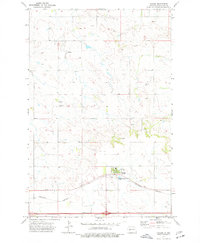
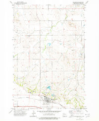
 1973 South Heart1978 Print · USGSSouth Heart and the surrounding Stark County prairies are captured here in the early 1970s as the railroad and river systems define the local economy. Genealogists and historians can locate St Marys Ch and trace the path of the Burlington Northern toward Edward Arthur Patterson Lake.
 - 1974 Map of Killdeer, 1976 Print
 1974 Killdeer1976 Print · USGSWestern North Dakota's ranching and rail country comes into focus in the mid-seventies, showing the prairie landscape before modern energy booms. Trace the Burlington Northern line through Dodge, Werner, and Golden Valley, or locate family landmarks near Manning and New Hradec.
End of results
Showing maps 1-21 of 21
Top cities of Stark County
- Dickinson historical maps
- Belfield historical maps
- Richardton historical maps
- South Heart historical maps
- Gladstone historical maps
- Taylor historical maps
Frequently asked questions
- What are the different types of historical maps available for Stark County?
- What is the oldest map of Stark County?
- Where can I purchase historical maps of Stark County for my home or office?
- Where can I download high-res historical maps of Stark County?
- Are there historical topographic maps available for Stark County?
- Is there historical aerial imagery available for Stark County?
- Where are historical maps of Stark County sourced from?