
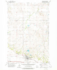
1973 Map of Marshall SE
USGS Topo · Published 1977About this map
The borderlands of Dunn Co and Stark Co are captured here in the early 1970s, showcasing a landscape defined by agricultural infrastructure and the essential search for water. The terrain is dotted with several Spring and Well locations, reflecting the critical nature of water management in this part of North Dakota. Evidence of the region's farming economy is visible at a group of Storage Bins situated near the southern county line. Mapped using photogrammetric methods from 1972 aerial photography, the topography reveals a detailed network of section lines and rural access routes that structured the high plains during this era. This survey highlights the spatial relationship between administrative boundaries and the practical landmarks of prairie life.
Find a feature on this map
4 named features on this map. Tap any name to fly to it.
Don’t see what you’re looking for? This feature index may not catch every label — zoom into the map to look around manually.
Map Details
Editions of this 1973 Marshall SE Map
This is the sole edition of this map. No revisions or reprints were ever made.
Other maps of this area

1953 · Dickinson
USGS Topo · 1:250,000

1953 · Watford City
USGS Topo · 1:250,000

1957 · Dickinson
USGS Topo · 1:250,000

1957 · Watford City
USGS Topo · 1:250,000

1967 · Watford City
USGS Topo · 1:250,000

1973 · Taylor
USGS Topo · 1:24,000

1973 · Willow Creek West
USGS Topo · 1:24,000

1973 · Schaffner Creek
USGS Topo · 1:24,000

1973 · Marshall SW
USGS Topo · 1:24,000
1973 · Richardton
USGS Topo · 1:24,000